Winsor Creek – Stewart Lake – Winsor Trail Hike
In Pecos Region
Map File Source: NG Topo
 Hike Key: H10496
Last Updated: 06/30/2021 12:00am
Last Updated By: Marilyn Fixer
Hike Class: E (Most difficult)
Hike Distance: 11 mi
Minimum Elevation: 8200 ft
Elevation Change: 1800 ft
Total Uphill: 1865 ft
Total Downhill: 1865 ft
Avg. Grade: 8 %
Route Type: CCW Loop
On Trail: No
Paved or Gravel Roads: Yes
GPS Advised: No
Hiker Limit (NF/BLM/NP): 15 (Pecos Wilderness)
Drive Distance Round Trip: 200 mi
Drive Time One-Way: 2:00
Hiking Seasons: Summer and Fall
New Mexico Game Unit: 45
Hike Status: Published
Highlights
A strenuous hike in the woods. Aspen forest and views to the west on the way up; views of Winsor Creek on the way back. Lush wildflowers.
CautionsSteep (12% grade) uphill. Hiking poles recommended. High altitude; not recommended for hikers with respiratory disorders. Lots of down timber on the Winsor Cr side.
Trailhead Directions
Go north on I-25 to Exit 299 Glorieta. Cross over the highway, turn right onto NM 50, and travel 6 mi to the town of Pecos and a junction with NM 63. Turn left, and proceed 20.2 mi to Cowles. Make a left turn over the Pecos River onto Forest Road 121. Continue on this road for a little over a mile to the end of the road and Winsor Creek Campground.
Actual Hike
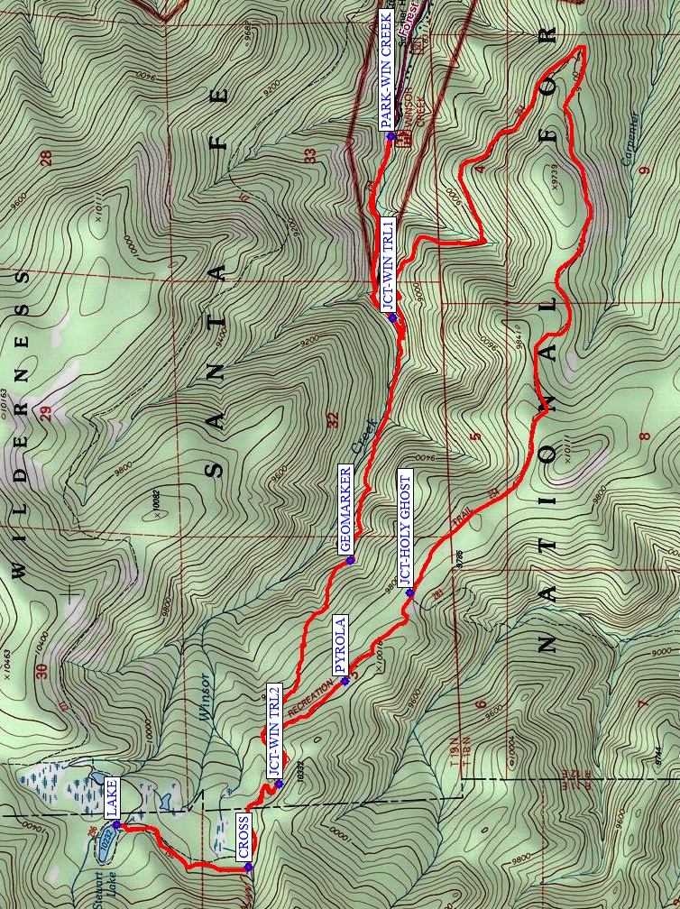
From PARK, start hiking on the Winsor Trail. There’s a meadow here with great wildflowers in the summer. At JCT-WIN CREEK (0.9 mi), continue straight (don’t take the left that continues the Winsor Trail). Note that the Winsor Creek trail is no longer maintained. Pass the GEOMARKER (1.8 mi) up to a JCT-WIN TRL (2.85 mi), CROSS (3.3. mi) the creek and turn right to go to the LAKE (3.9 mi). Have lunch there. Return back the way you came and CROSS (4.6 mi)the creek again. At the JCT-WIN TRL (5.0 mi), take the right option to continue on the Winsor Trail. It’s a longer way down, but through a drier landscape with aspens and different views. Stop at PYROLA (5.5 mi) to admire the flowers if they are in bloom. Keep going straight at the JCT-HOLY GHOST (6.0 mi). After this, follow the Winsor Trail all the way to JCT-WIN CREEK (10.2 mi), then back to PARK-WIN CREEK (11.0 mi).
Comments
THIS HIKE WILL RETURN LATE.
The Winsor Creek portion is steep and not maintained. A waypoint is provided for the Pecos DQ in case you want to stop for refreshments after the hike.
The hike data were determined from a track recorded by a GPSMap 60CSx and the digital elevation model in National Geographic Topo mapping software.
WaypointsPARK: N35 48.965, W105 40.715
JCT-WIN CREEK: N35 48.958, W105 41.438
GEOMARKER: N35 49.096, W105 42.403
JCT-WIN TRL: N35 49.327, W105 43.298
CROSS: N35 49.428, W105 43.628
LAKE: N35 49.856, W105 43.457
PYROLA: N35 49.115, W105 42.887
JCT-HOLY GHOST: N35 48.904, W105 42.533
DQ N35 34.509 W105 41.763
Map Filename: WinsorCreek-StewartLake-WinsorTrailMap1_MW.jpgHike GPS File Name: WinsorCreek-StewartLake-WinsorTrail1_MW.gpx
Hike GPS File: Click link to download hike waytrack file
Text Author: Marilyn Warrant
Map Author: Marilyn Warrant
Waypoints Author: Marilyn Warrant
Track Author: Marilyn Warrant
Maintainer: Marilyn Warrant
Editor: Howard Carr