Last Overall Update: 1/30/19
These are casual references; they are not formal references as in articles and books. Their inclusion here is not an endorsement. Use your own judgement about the suitability of the material. Most of the descriptive information below was copied directly from the resources with minor editing. If you have or know of a resource that should be added, please send the information to us via the form at Communications -> Contact Us.
A free reader for Adobe PDF files is available.
Click here to download Adobe’s free PDF file reader.
General
- 2017 Hiker Survey Results
- The results of the 2017 hiker survey in a PDF document (3 pages). Thanks to Joan Weissman for spearheading the effort.
- Senior Pass
- A Senior Pass costs $80 for a lifetime pass or $20 for an annual pass to access Bureau of Land Management, Forest Service, Fish & Wildlife Service, National Park Service, and Bureau of Reclamation lands.
Geology
- A Geologic Guide to the Quebradas Back Country Byway
- A PDF document (11 pages) describing geologic features that may be observed at stops along the Quebradas Back Country Byway. Has color pictures and diagrams.
- Volcanoes of New Mexico: An Abbreviated Guide for Non-specialists
- A PDF document (12 pages) about two dozen areas where the non-specialist may see volcanoes or volcanic landforms. Little materials about New Mexico’s volcanoes has been published for the general public.
Has color pictures and diagrams.
GPS
- Frequently Asked Questions – GPS Use
- A PDF document (6 pages) whose purpose is to help GPS owners use their GPS more effectively during a hike. Some of the information in this document assumes the use of a Garmin GPSmap or Legend/Vista series GPS.
- New Mexico Topo Map
- A free detailed electronic topographic map of the entire state of New Mexico at 24k detail. This map is created for Garmin GPS receivers and BaseCamp. It received a complete overhaul in 2016. Note that this map is not “routable” (topo maps sold by Garmin are routable). GPSFileDepot has Garmin-compatible maps for many other areas of the U.S., and some for other countries.
- Southwest Trails
- A map overlay for Garmin GPS receivers. Southwest Trails is a “transparent” mapset, which means that when it’s loaded with other MapSource products (or your GPS basemap) the trails appear as data laid over the other maps.
- Using a Garmin GPSMap 60CSx
- A PDF document whose purpose is to help owners of Garmin GPSMap 60CSx’s use these GPS receivers.
- Using a Garmin GPSMap 64s
- A PDF document whose purpose is to help owners of Garmin GPSMap 64s’s use these GPS receivers.
Hiker Safety
- Heat-related Illnesses and First Aid
- Recommendations from the Occupational Safety and Health Administration.
- Lightning
- No place outside is safe from lightning. In town the safest place would be a modern building or a metal-topped vehicle. In the backcountry there are four actions that can reduce your lightning risk. Do you know what they are?
See a web-friendly version of the National Weather Service’s “Backcountry Lightning Risk Management” or the brochure itself.
- Snake Bites
- If you have ever worried about getting a snake bite out on a hike you might be interested in information about venomous New Mexican snakes (including pictures) and snake bite prevention and ‘dos and don’ts’ from the NM Poison Control Center.
- Van First Aid Kit
- Each van contains a first aid kit. Current contents and recommended additions and deletions for the van first aid kit were developed by the First Aid Committee.
This committee also developed a list of contents for a van small first aid kit that could be carried by the hike leader.
- Wilderness First Aid
- You can download a copy of the official course guide for the American Red Cross Wilderness and Remote First Aid course or purchase a copy along with a weather-resistant pocket reference designed for use in the field. Some of the topics covered in the 113 page guide include altitude illnesses, hypothermia, shock and heart attack, poisoning, and wounds and wound infection.
- Wind Chill Chart
- Chart of temperature and wind speed showing effective temperature. Also shows time until frostbite.
Hiking – Books
Title | Author(s) | Pub Date | Publisher | Description |
|---|---|---|---|---|
60 Hikes Within 60 Miles: Albuquerque: Including Santa Fe, Mount Taylor, and San Lorenzo Canyon, 3rd Edition | David Ryan and Stephen Ausherman | 2019 | Menasha Ridge Press | This newly updated and revised edition of 60 Hikes within 60 Miles: Albuquerque hits classic trails and uncovers paths where no guidebook has gone before. This is the essential guide to north-central New Mexico, from the black lava badlands in El Malpais National Monument to the cool aspens in Santa Fe National Forest. Explore newly opened lands in the Ojito Wilderness and the Valles Caldera, or revisit the past with nostalgic walks along the Rio Grande and Route 66. Hikes lead to ancient pueblos, ghost towns, slot canyons, strange hoodoos and other treasures in the heart of New Mexico, all just a daytrip or less from the Duke City. |
100 Hikes in New Mexico, Third Edition | Craig Martin | 2010 | The Mountaineers Books | New Mexico offers a surprising variety of terrain to explore, from the Chihuahuan Desert in the south to remarkable alpine lakes in the Sangre de Cristo Mountains to the north. In this completely updated guide to New Mexico s impressive trails, author Craig Martin includes easy 1- and 2-mile day jaunts, numerous 8- to 12-mile hikes, and difficult 20-plus-mile backpack trips for the more ardent adventurer. |
Day Hikes in the Santa Fe Area, 9th Edition | The Northern New Mexico Group of the Sierra Club | 2023 | The Northern New Mexico Group of the Sierra Club | Santa Fe's most popular Hiking Guide, Day Hikes in the Santa Fe Area details 68 hikes in and around Santa Fe. Complete with directions to each hike, round trip mileage traveled as well as rating guides (easy to strenuous), lat/longs for the GPS-inclined and elevation gains for each trail, this book is the definitive guide for every type of hiker, desert to mountain, novice to advanced. |
Hikers and Climbers Guide to the Sandias | Mike Hill | 1983 | University of New Mexico Press | The Sandias, or Oku Pin -- the sacred mountain of the Pueblo Indians, are a popular recreation area with over 31,00 acres in the National Wilderness Preservation System. This book is an invaluable compendium and companion for the amateur setting off into the Sandias for the first time as well as for the expert enthusiast who wishes to plan new explorations into the New Mexico wilderness. |
Hiking Trails of the Sandia and Manzano Mountains | Kay Matthews | 1984 | Heritage Association Inc. | Includes cross-country ski information. In the early 1970s, Kay Matthews worked for the Sierra Club in Santa Fe, the Albuquerque Environmental Center and as a seasonal employee of the United States Forest Service. In 1978 she was hired as the wilderness patrol in the newly designated Sandia Mountain Wilderness and begin teaching the "Hiking in the Sandias" continuing education course at the University of New Mexico. She has also taught cross-country skiing in the Community College program. |
New Mexico's Continental Divide Trail | Bob Julyan | 2001 | Westcliffe Publishers | The landscape of New Mexico inspires a sense of peace, awe, and grandeur unlike any other state--and it contains some of the country's most remote and unexplored natural areas. For day hikers, campers, or backpackers planning a long trek, this guide is absolutely essential for charting your way through this rugged and dramatic landscape. Well-known writer Bob Julyan's precise and entertaining prose, combined with Tom Till's extraordinary photographs, lead the reader through hundreds of miles of breathtaking scenery. |
New Mexico's Wilderness Areas: The Complete Guide | Bob Julyan | 2006 | Westcliffe Publishers | This comprehensive guide to New Mexico's wild lands includes not only such wellknown areas as Gila and Pecos wildernesses, but also lesser-known regions such as Latir Peaks, Apache Kid, and Bisti De-na-zin wildernesses. It also provides an inventory of the state's more than 50 wilderness study areas--the wilderness areas of the future. With text by New Mexico author Bob Julyan and illustrated with pictures by Tom Till, one of the southwest's finest outdoor photographers, the book provides a richly colored portrait of New Mexico's wilderness heritage, including suggestions for hikers and insights into each area's unique natural and human history. |
Sandia Mountain Hiking Guide | Mike Coltrin | 2019 | University of New Mexico Press | This classic hiking guide to Albuquerque's Sandia Mountain is completely updated with color photographs, up-to-date trail descriptions, detailed maps, additional GPS data, and modified difficulty ratings for many of the featured hikes. This expanded edition also includes seven new trail descriptions, two dozen "Family Friendly" outings for hikers of all ages and abilities, and insightful "Safety First" considerations for moderate-to-difficult trails. The beautiful hikes described here, including round-trip distances, total about three hundred miles. Individual entries detail the length, elevation gain, and degree of difficulty for each trail. The author also provides detailed directions to trailheads and describes the trail terrain, scenic viewpoints, vegetation, and neighboring trails. Twenty-six contour maps of the trails throughout the Sandias are included in the interior. Additionally, a stand-alone, water-resistant, color map of the mountain trail system has been updated to accompany the hiking guide.. |
Hiking – Websites
- Hiking Meetups near Albuquerque, NM
- Meetups for people who are interested in hiking.
- Sandia Mountain Hiking Guide
- The website provides additional information about hikes in the Sandia Mountains, including GPS tracks and waypoints. Note that the original website has been archived.
- https://www.myopencountry.com/hiking-for-beginners/.
- This Hiking guide will teach you how to get started in hiking, what gear beginner hikers should look at, especially hiking boots, socks and backpacks that is available from outdoor stores today, and how to make the right choice that will fit your personal requirements for the hiking trail you want to hike.
Indian Ruins/Petroglyphs
- Indian Pottery
- The resources and links on this site are meant to provide a basic introduction to the ceramic traditions of many portions of the U.S. Southwest and Northern Mexico.
Insects
- Bug Guide
- Identification, Images, & Information For Insects, Spiders & Their Kin For the United States & Canada. We are an online community of naturalists who enjoy learning about and sharing our observations of insects, spiders, and other related creatures.
- What’s That Bug?
- Lots of bug information. Do you have a bug you need identified? Ask What’s That Bug?
Land Ownership
- Land Ownership Information and GPX Links (last updated 10/5/21)
- A document whose purpose is to help you understand land ownership. Has links to GPX files which are the boundaries of various areas.
Maps
- Bernallilo County Open Space Maps
- For maps and supporting information, see below.
- BLM New Mexico Maps
- The BLM no longer provides their paper maps online (you can still pick them up at the BLM office). However, they have two online resources that for many people will replace the paper maps. They are (1) an online interactive map of New Mexico that is said to be current as of the date viewed and (2) the CarryMap application that can load onto your desktop, laptop, or mobile phone quadrants or the entire New Mexico land ownership map. This document includes instructions for accessing and using these map resources.
- City of Albuquerque Open Space Maps
- Website
- Manzanita Mountains Trail System Map
- Sandia Ranger District map of the hiking/bike trail system.
New Mexico Game Units
- Map of New Mexico Game Units
- If you know a hike’s game unit, you can determine the period when big-game hunting with rifles is allowed there. Then you can avoid scheduling that hike during that time.
Photography
- Google Photos
- Instructions for preparing a web photo album using Google Photos.
Plants/Flowers/Trees – Books
| Title | Author(s) | Pub Date | Publisher | Description |
|---|---|---|---|---|
| A Field Guide to the Plants of Arizona | Anne Orth Epple | 1995 | Falcon | More than 900 color photographs and descriptive text identify Arizona's unique flora, including wildflowers, cacti, trees, and other plant life. Helpful for desert plants that overlap ranges with New Mexico. |
| A Guide to Plants of the Northern Chihuahuan Desert | Carolyn Dodson | 2012 | University of New Mexico Press | This book provides practical identification guide, offering descriptions of 75 representative species of northern Chihuahuan Desert plants. Each illustrated profile includes the plant's common and Latin name and a brief description, as well as its role in human history, |
| Desert Wildflowers of North America | Ronald J. Taylor | 1998 | Mountain Press Publishing Company | One of the few books on desert wildlfowers. Covers the Mojave, Sonoran, Painted, Chihuahuan, and Great Basin Deserts. More than 500 species of flowering plants with color photographs. |
| Field Guide to Sandia Mountains | Robert Julyan and Mary Stuever, eds. | 2005 | University of New Mexico Press | Rather than a comprehensive field guide, the selections offer the most commonly encountered species in each category, presenting information on just over 100 species of flowers, for example, among almost 500 species that can be found in the mountains. |
| Flowering Plants of New Mexico, Fifth Edition | Robert DeWitt Ivey | 2008 | RD & V Ivey | Field guide to wild plants of New Mexico, approximately 1500 illustrated. Additional sections on ecology, edibility, identification, habitats, and range maps. This is the book to get if you are serious about identifying wildflowers in New Mexico. |
| Land of Enchantment Wildflowers: A Guide to the Plants of New Mexico | Willa F. Finley and Lashara J. Nieland | 2013 | Texas Tech University Press | This book is a delightful new addition to the list of books celebrating New Mexico’s wildflowers. It contains an excellent representation of 200 commonly encountered plants throughout New Mexico. Although not a true field guide with taxonomic keys and plant descriptions, it does contain excellent photographs that help with identification, including photos of similar species, life stages, close-ups, and growth habits. |
| Rocky Mountain Flower Finder: A Guide to the Wildflowers Found Below Tree Line in the Rocky Mountains | Janet L. Wingate | 1990 | Nature Study Guild Publishers | This book uses a decision tree that guides you to the flower by answering questions about the flower's characteristics (e.g. if flower has regular shape go to p. 12, if irregular go to p. 15. Next, if flower has basal leaves, go to p. 20, etc.) The book has an explanation and drawings of the terms used for identification. It has line drawings and written descriptions of the flowers. It is small and easily fits in your pocket for a hike. |
| Wildflowers of the Northern and Central Mountains of New Mexico | Larry J. Littlefield and Pearl M. Burns | 2015 | University of New Mexico Press | This unique reference work describes over 350 wildflowers and flowering shrubs that grow in New Mexico's Sangre de Cristo, Jemez, Sandia, and Manzano Mountains, as well as neighboring ranges, including the Manzanita, San Pedro, Ortiz, and other lower-elevation mountains in central portions of the state. |
| Wildflowers of the Sandia and Manzano Mountains of Central New Mexico | Larry J. Littlefield and Pearl M. Burns | 2011 | Sandia Plant Books | This superbly illustrated book includes 201 wildflowers and flowering shrubs in the Sandia and Manzano Mountains illustrated by more than 700 color photographs. All species included are accompanied by nontechnical descriptions based on easily discernable, visual characters. Photographs of each species include flowers and other organs showing various stages of plant development. |
Plants/Flowers/Trees – Websites
- New Mexico Thistle Identification Booklet
- This identification guide focuses on the thistle genus Cirsium and the two common plumeless thistle species that may be mistaken for Cirsium. It does not include other non-native plants with the word “thistle” in their common names, such as Russian thistle, sowthistle and starthistle.
- Southwest Environmental Information Network (SEINet)
- Website
- Southwest Colorado Wildflowers, Ferns & Trees
- Website for the identification and appreciation of mountain and desert wildflowers, ferns, and trees of the Four Corners area of Colorado, New Mexico, Arizona, and Utah.
- Vascular Plants of the Gila Wilderness
- Website
- Wildflower Search
- Search for wildflowers by location (on a map or from lat/long coordinates throughout the U.S.), color, number of petals, habitat and time of observation. Your search can use any combination of these criteria.
- Wildflowers of New Mexico
- A website created by George Oxford Miller of the New Mexico Native Plants Society. Includes wildflower descriptions, photos, and identification aids for plants throughout New Mexico. View plants by species, family, or common name. Search plants by color then botanical characteristics. Includes an illustrated Glossary of plant terminology.
- Wildflowers of the Manzanos by Gene Jercinovic
- A website devoted to wildflowers found in the Manzano Mountains. Short articles including drawings by Robert DeWitt Ivey.
- Wildflowers of the Southern Rocky Mountains — A guide to the flora of Colorado and New Mexico
- Website
Rocks and Minerals
- Barite
- Barite (BaSO4) is a common mineral which contains barium and which has an exceptionally high density (4.5 g/cm3) for a non-metallic mineral. It is also relatively soft (MOHS hardness ~2.5). It is radio-opaque and is used as a component in radiation shield structures. However, its most extensive use is as a component in the “mud” used in drilling for oil. It is used to increase the density of the mud so that it effectively helps float the crushed rock debris from the drill bits. Because of barite’s softness the mud does not abrade the drill bits. The increased density of the barite-enhanced mud also counteracts the hydrostatic pressure of the rocks and fluid surrounding the drill pipe so that the drill pipe is not crushed. In short, one could not drill for oil without barite.
See also the geology.com website article.
- Gypsum
- See the geology.com website article.
- Quartz
- See the geology.com website article.
Senior Centers
- Welcome Flyer for New Hikers
- See Welcome Flyer for new hikers.
Trail Etiquette: Who Has the Right of Way?
- REI Article on Trail Etiquette.
- View it.
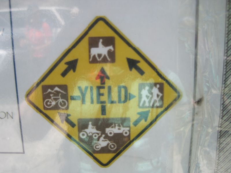
- Yield Sign for the Manzanitas Bike Trails
- View it.
Van Safety
- Changing a Flat Tire on a Senior Van
- Instructions (with photos) for changing a flat tire on a senior van.
- Van Drivers Checklist
- Checklist and problem report for van drivers.
- Vehicle Access to Santa Fe National Forest Areas
- The Santa Fe National Forest now has free Motor Vehicle Use Maps published annually. They have put those maps online here. There are 3 maps, one for the East (Sangre de Cristos & Pecos), one for the Northwest (San Pedro Parks and north of the Valles Caldera), and the Southwest (most of our hikes in the Jemez). To view the roads and closure information, click on the part of the forest of interest. A pdf file will open. Use the + to zoom in. Depending on the part chosen, you may need to rotate the map counterclockwise in order to read the legend. All of the roads that don’t have a seasonal designation will be open mid-April to the end of December, then will be closed for the winter. Contact the Jemez Ranger Station for spring opening dates for the given year, which depend on factors such as amount of snow, runoff, and giving the wildlife a chance to have their babies in peace.