Arroyo Del Tajo Hike
In Socorro Region
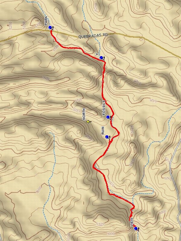
Map File Source: DeLorme
 Hike Key: H10501
Last Updated: 03/11/2021 12:00am
Last Updated By: Marilyn Fixer
Hike Class: B (Moderate)
Hike Distance: 5.3 mi
Minimum Elevation: 5135 ft
Elevation Change: 300 ft
Total Uphill: 370 ft
Total Downhill: 370 ft
Avg. Grade: 3 %
Route Type: InOut
On Trail: No
Paved or Gravel Roads: No
GPS Advised: Yes
Drive Distance Round Trip: 180 mi
Drive Time One-Way: 1:45
Hiking Seasons: Spring, Fall, and Winter
New Mexico Game Unit: 18
Hike Status: Published
Access Description: Quebradas Access
Highlights
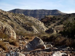
Pleasant stroll down an arroyo to a spectacular notch in a rugged ridge.
CautionsThe hike is off trail. Poles may be useful.
Trailhead Directions
From Albuquerque take I-25 south to the Lemitar exit. Go east for 0.5 mile on SR 408 E. Turn right onto SR-408 and go 3 miles to Escondido (Hidden) Lake. Turn left and go 1.6 miles (the road curves to the right after crossing the Rio Grande) to a sign “Quebradas Back Country Scenic Byway.” Turn left and go 9.5 mi. to PARK. Park on the right after crossing the arroyo where there is a pullout.
Actual Hike
Go east from parking, working down into the arroyo. Continue south in the main arroyo. You will reach a large rock on the right shoulder of the arroyo where there are a number of shell FOSSILS (1.2 mi). See how many you can find. There are 2 very prominent ones. Then continue to the RUIN (1.5 mi) to the right of the arroyo. Then continue in the arroyo. At the 2 mile point is the entry to the notch. There is usually a pool of water filling the entry to the notch, which is impassable. If this is true enter the notch by going up the left side of the entry area and find a crevice which is a path into the notch. Once in the notch, it is impressive with high walls. At 2.6 miles the notch ends. Going on down the arroyo at this point is very difficult. Instead go up the left side of the end of the notch to VIEW (2.7 mi). The hike ends there. Return back through the notch and back up the same arroyo. When the Y (4.7 mi) is reached, be sure to go left up the main arroyo.
Comments
This hike is in the Presilla WSA, wilderness restrictions apply.
WaypointsPARK: N34 03.321, W106 46.484
FOSSILS: N34 02.867, W106 47.322
RUIN: N34 02.877, W106 47.506
VIEW: N34 02.649, W106 48.362
Y: N34 02.921, W106 46.769
Hike GPS File Name: ArroyoDelTajoWayTrack_DBDB.gpx
Hike GPS File: Click link to download hike waytrack file
Text Author: Dick Brown
Map Author: Dick Brown
Waypoints Author: Dick Brown
Track Author: Dick Brown
Maintainer: John Cooper
Editor: Howard Carr