Tram to La Luz Hike
In Sandia Mountain West Region
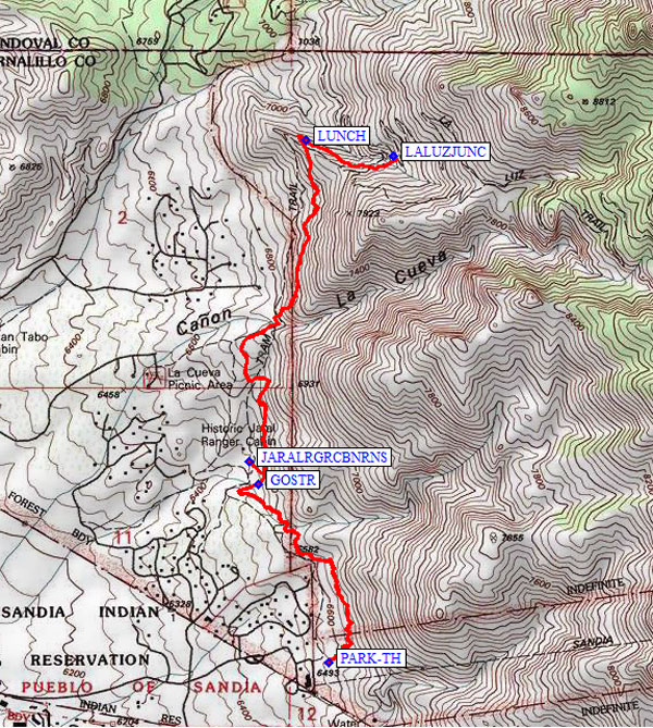
Map File Source: NG Topo
 Hike Key: H10198
Last Updated: 06/30/2021 12:00am
Last Updated By: Marilyn Fixer
Hike Class: C (Challenging)
Hike Distance: 5.2 mi
Minimum Elevation: 6553 ft
Elevation Change: 1184 ft
Total Uphill: 1452 ft
Total Downhill: 1452 ft
Avg. Grade: 11 %
Route Type: InOut
On Trail: Yes
Paved or Gravel Roads: Yes
GPS Advised: No
Drive Distance Round Trip: 30 mi
Drive Time One-Way: 0:15
Hiking Seasons: Spring, Fall, and Winter
New Mexico Game Unit: 8
Hike Status: Published
Highlights
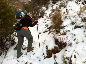
An enjoyable foothills hike with lots of large boulders and desert plants.
CautionsLots of elevation gain in this relatively short hike. Trekking poles are strongly recommended.
Trailhead Directions
Take Tramway Blvd north to Tramway Rd. Follow signs to Tram station. The trailhead for the Tram To La Luz trail (trail 82) is in the northeast corner of the upper, northeast parking lot.
Actual Hike
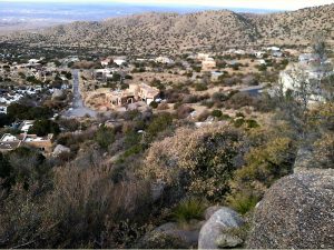
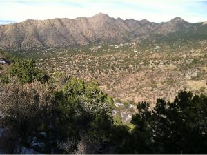
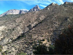
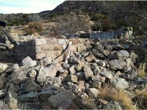
From the trailhead (PARK-TH, 0.0 mi), hike north for about three quarters of a mile where you will descend into an arroyo (GOSTR, 0.74 mi). Go straight across the arroyo and on for a short distance, where you will see a trail on the left leading to Spring Creek. Take this left and walk a short way to the ruins of the Jaral Ranger Cabin (JARALRGRCBNRNS, 0.84 mi). According to Mike Coltrin, it was probably built in the 1930s by the CCC, and “was used by Forest Rangers as a base to monitor the western side of the Sandia Mountains until the early 1960s.” Return to the Tramway Trail and continue northward. At this point the trail will start gaining elevation quickly as you hike toward a ridge, with large homes below. You will see FR 333 below to the west which leads to the La Luz trailhead. At about 2.3 miles, you reach the ridge, where the trail crosses it, turns sharply to the right and drops down its back, continuing into the La Luz drainage. After reaching the ridge, continue on for a short distance until you come to some rocks that are a good place for lunch (LUNCH, 2.37 mi) on the return leg of the hike. As you hike onward, you should see the La Luz trail climbing up the mountain on your left. Continue on until the trail joins the La Luz trail (LALUZJUNC, 2.7 mi). Turn around at the junction and retrace your steps until you arrive back on top of the ridge. Stop at the lunch spot and eat while you enjoy the view. Return the way you came to the trailhead.
Comments
This hike is best done in winter when the lack of shade is not an issue, although there are occasional shady spots. There is a surprising amount of elevation gain in this relatively short hike, so you will be getting a workout, and trekking poles are strongly recommended. The hike is above some large residential homes, but far enough away to make for an enjoyable foothills hike with lots of large boulders and desert plants.
The Sandia Ranger District has set a 25-hiker limit for this area.
WaypointsPARK-TH: N 35 11.503, W 106 28.745 (0.00)
GOSTR: N 35 11.963, W 106 28.967 (0.74)
JARALRGRCBNRNS: N 35 12.023, W 106 28.994 (0.84)
LUNCH: N 35 12.853, W 106 28.817 (2.37)
LALUZJUNC: N 35 12.812, W 106 28.540 (2.70)
Hike GPS File Name: TramToLaLuzWayTrack_HCHC.gpx
Hike GPS File: Click link to download hike waytrack file
Text Author: Nancy Carr
Map Author: Marilyn Warrant
Waypoints Author: Howard Carr
Track Author: Howard Carr
Maintainer: Nancy Carr
Editor: Howard Carr