Tunnel Springs Hike
In Placitas Region
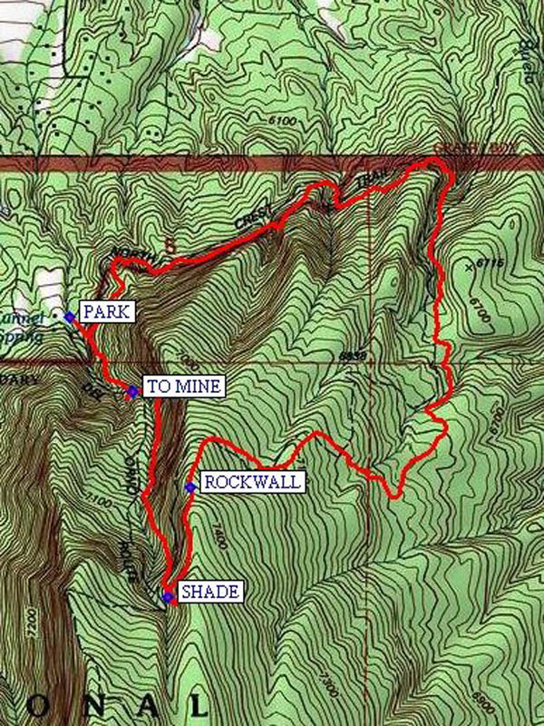
Map File Source: NG Topo
 Hike Key: H10199
Last Updated: 12/15/2020 12:00am
Last Updated By: Marilyn Warrant
Hike Class: D (Difficult)
Hike Distance: 4.3 mi
Minimum Elevation: 6255 ft
Elevation Change: 1178 ft
Total Uphill: 1240 ft
Total Downhill: 1240 ft
Avg. Grade: 13 %
Route Type: Loop
On Trail:
Paved or Gravel Roads:
GPS Advised:
Drive Distance Round Trip: 50 mi
Drive Time One-Way: 0:45
Hiking Seasons: Spring and Fall
New Mexico Game Unit: 8
Hike Status: Inactive
Highlights
Views of Placitas and the Sandias to the east; visit the entrance to an old mine.
CautionsSteep descent with little rocks on the way back, so hiking poles recommended and wear boots with good soles.
Trailhead Directions
I-25 north to Placitas exit (exit 242). Go east on SR 165 for 5 miles. Tunnel Springs Road (Forest Road 231) is on the right, just before mile marker 5 at LEAVE SR 165. Follow it (rough dirt road) and signs for about 1.5 miles to the Tunnel Springs trailhead. Pay fee there, continue on to the parking area, and PARK (0.0 mi). Note the springs pouring water out a pipe at south side of road just before entering parking area.
Actual Hike
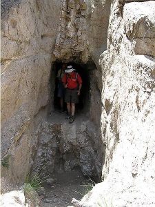
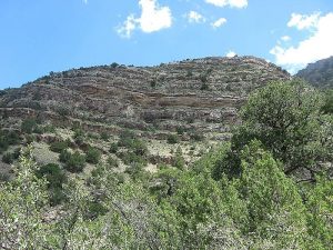
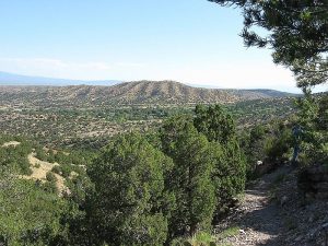
Follow trail in an easterly direction without any climbing, then under towering stone cliffs. The trail eventually turns south onto North Crest Trail, climbing up a deep rocky canyon. Looking east beyond you will see the Las Huertas (The Orchards) Canyon which has many homes. After reaching the top of the canyon you can see the North Peak. Trail then turns west over two ridges to where you’ll have a great view of the trailhead far below. This is a good lunch spot — volunteers have built a ROCKWALL (3.0 mi) there amongst steep rock cliffs. Or you could continue to SHADE (3.3 mi) instead for lunch, which is just past the junction with the Ojo del Orno Canyon Trail where the sides of canyon converge. Going north on the Ojo del Orno Canyon Trail is the toughest part of the hike, since it follows a rocky (loose) arroyo. The trail goes down the west face of the canyon and ends up directly in front of the trailhead. Near the end of Ojo del Orno is a very short (50-100 paces — one minute) trail off to the left to the tunnel (TO MINE (4.0 mi)), which we were told was an unsuccessful gold mine. It is, unfortunately, difficult to enter because of a huge pit in front of the entrance. Note the “vein” above the entrance.
Comments
Great views to north, east, west. Pick out Cabezon, Mt. Taylor, Coronado’s Thumb, Jemez Dam, Sangre de Cristo, Ortiz and San Pedro mountains. Since this hike is on the north side of the Sandias, you can expect to still find snow in the canyon in the spring, so may have to go back the same way you went up. Bring your hiking sticks, there are some really steep parts on the return (20% grade). Because of this, the hike rating has been increased to D. Note that the waypoints, obtained from Trimble Navigation, don’t match the diagram.
This hike has been replaced by the Tunnel Spring to Crest hike which is an in-out hike eliminating the del Orno portion.
WaypointsLEAVE SR 165: N 35 18.395, W 106 27.086
PARK: N 35 17.489, W 106 26.369
ROCKWALL: N 35 17.134, W 106 26.064
SHADE: N 35 16.906, W 106 26.120
TO MINE: N 35 17.334, W 106 26.210
Hike GPS File Name: TunnelSpringsWayTrack_DBDB.gpx
Hike GPS File: Click link to download hike waytrack file
Text Author: Roger Holloway
Map Author: Marilyn Warrant
Waypoints Author: Dick Brown
Track Author: Dick Brown
Maintainer: Marilyn Warrant
Editor: Howard Carr