Tecolote Peak and Tree Spring Hike
In Sandia Mountain East Region
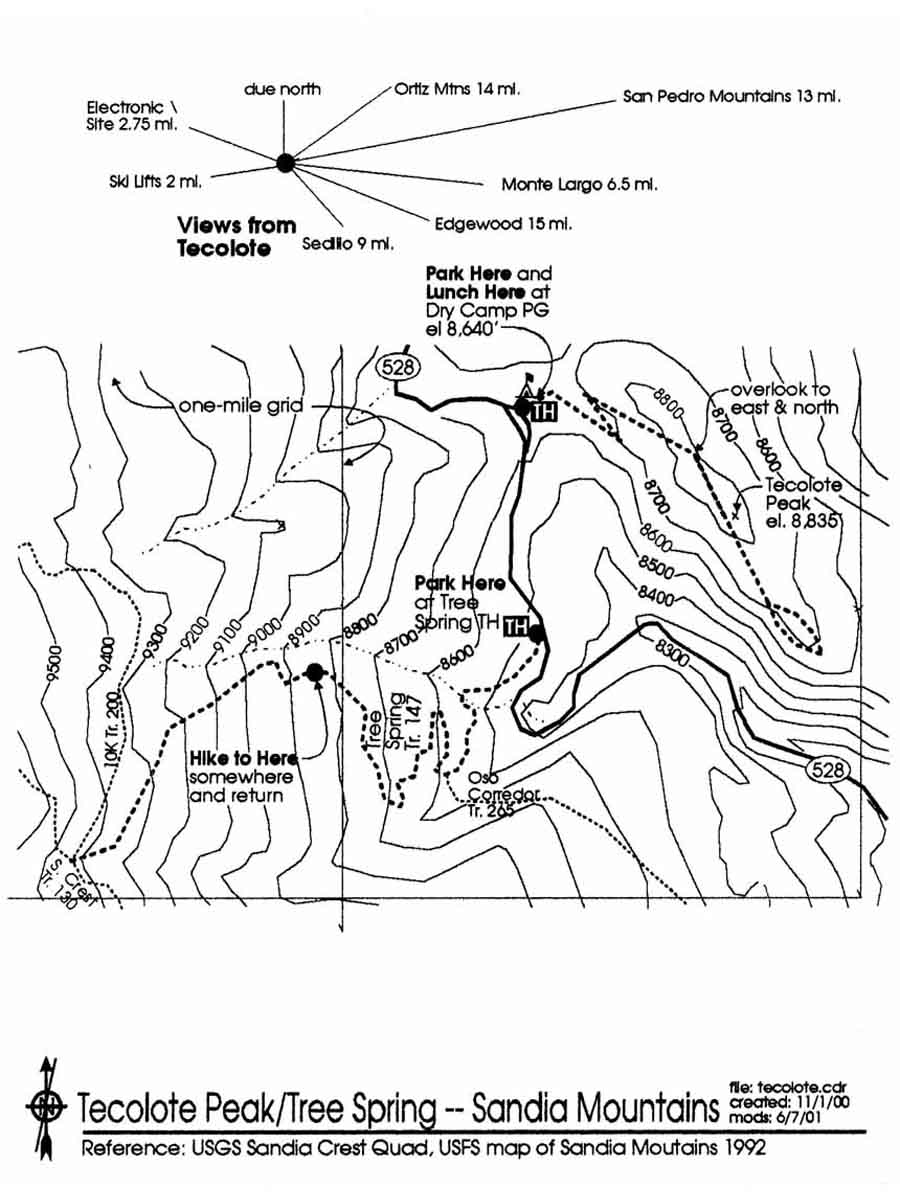
Map File Source: Roger Holloway
 Hike Key: H10220
Last Updated: 03/10/2021 12:00am
Last Updated By: Marilyn Fixer
Hike Class: C (Challenging)
Hike Distance: 5.4 mi
Minimum Elevation: 8500 ft
Elevation Change: 945 ft
Total Uphill: 945 ft
Total Downhill: 945 ft
Avg. Grade: 10 %
Route Type: InOut
On Trail:
Paved or Gravel Roads:
GPS Advised:
Drive Distance Round Trip: 50 mi
Drive Time One-Way: 0:30
Hiking Seasons: Summer and Fall
New Mexico Game Unit: 8
Hike Status: Inactive
Cautions
None.
Trailhead Directions
I-40 East to Tijeras exit 175, then immediately take left fork (Cedar Crest) to go north on SR 14. Go through Cedar Crest and then left onto the SR 536 (Sandia Crest Scenic Byway). After Doc Long and milepost 5 you’ll find Tree Springs on the left. Look over to the right and that is Tecolote Peak. Go about a half a mile to Dry Camp on the right. Tecolote (Owl) trail starts behind the outhouse.
Actual Hike
Tecolote Peak is a relatively new hike and is not on the map. Great place for wild flowers. The trail goes out from behind the outhouse and is well marked. It is maintained by the Friends of the Forest. It goes up the right (west) side of Tecolote, and after a while you can get a good view of the Sandia Crest on your right, with the Ski Lift and a little later, the electronic site, then you can see the road you came upon and the parking area for Tree Springs which follows this hike. After the first switchback to the left, and another 4 min. later, to the right, you will be on top and will proceed in a generally south direction to an overlook on your left (not marked) where you can see left to the east and north. Now you will be going gently down and in about six minutes you will be at a sign for the 1/4 mi. Loop. You can see to the east and southeast from here. We kept right and at the end of the loop (ten more min.) we could see the winding Crest Highway climbing below us. At this point it is interesting to note that we are nearly at the same elevation as we started. The peak really isn’t much of a peak, but rather a long, gradually descending strip with a 5′ mound at its highest point. Great views of all of the Sandias, though. In other places in the Sandias the view is blocked by trees. After this short hike we can eat our lunch in the Dry Camp Picnic Area, drive down to Tree Springs and hike up to Oso Corredo (1/3 mile and as far more as everyone is willing). It is interesting to note that at 1 3/4 miles from Tree Springs trailhead is the junction of Crest Trail and 10K Trail. On 6/7/01 we hiked for about 1.5 miles and turned back. Note: It might be a good idea to plan a picnic here (Dry Camp) with everyone bringing things to share, even cards and dominoes?! Then we could skip the Tree Springs leg.
Comments
Replaced by a hike only for Tecolote Peak.
Tecolote Peak 319 ft CE, 2.4 mi., starting elevation 8633 ft., maximum elevation 8823 ft. for change of 190 ft. Tree Spring portion 751 ft CE, 3 mi., minimum elevation 8487 ft., maximum 9232 ft. for a change of 755 ft. Of course, you can always skip the Tree Spring part or shorten it. The grade listed is for the Tree Spring part of the hike. The Tecolote Peak part has only a 5% grade.
WaypointsPARK-TECOLOTE: N 35 12.005, W 106 24.313
PARK-TREESPR: N 35 11.630, W 106 24.284
STOP: N 35 11.470, W 106 25.031
Hike GPS File Name: TecolotePeakandTreeSpringWayTrack_JBJB.gpx
Text Author: Roger Holloway
Map Author: Roger Holloway
Waypoints Author: John Boyd
Track Author: John Boyd
Maintainer: Marilyn Warrant
Editor: Marilyn Warrant