Tapia Canyon and Tower Ruin Hike
In Cabezon Region
Map File Source: NG Topo
 Hike Key: H10215
Last Updated: 12/06/2023 6:41pm
Last Updated By: Marilyn Fixer
Hike Class: C (Challenging)
Hike Distance: 6.1 mi
Minimum Elevation: 5950 ft
Elevation Change: 214 ft
Total Uphill: 360 ft
Total Downhill: 360 ft
Avg. Grade: 8 %
Route Type: InOut
On Trail: No
Paved or Gravel Roads: No
GPS Advised: Yes
Drive Distance Round Trip: 180 mi
Drive Time One-Way: 2:30
Hiking Seasons: Spring, Fall, and Winter
New Mexico Game Unit: 9
Hike Status: Published
Access Description: Cabezon Area Access
Highlights
Huge panels of petroglyphs, ruins, a natural arch, slot canyon, spectacular scenery.
CautionsPart of the route has a short steep ascent up the side of a cliff using indentations in the rock as “steps.”
Trailhead Directions
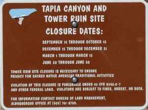
From Albuquerque, take I-25 north to Bernalillo exit 242 and drive northwest on US 550 to mile marker 41 and turn west at sign for San Luis-Cabezon. This is County Road 279 which you will follow for 32 miles. Mark your odometer here and follow the paved road thru the village of San Luis to the pavement end at mile 9. Continue southwest on the gravel-dirt road; at mile 13 stay west to mile 17.5 where you will turn left or south and reach a bridge over the Arroyo Chico at mile 20.5. Continue southwest to a junction at mile 22 where you will turn left or south. Drive southeast now to mile 26 and pass thru downtown Guadalupe. Continue southeast and carefully cross 2 arroyos. At mile 31.2 cross over a sharp ridge and note the parking and trail up to a Chacoan Outlier (Guadalupe RUINS). At mile 32 turn right at TURN2PARK. This dim, 2-track leads to PARK (0.0 mi) at mile 33. Please note the sign and Closure Dates. This hike is closed 9/15-10/15, 12/15-12/31, 3/1-3/15, and 6/20-6/30. You may call the BLM at 505-761-8700 to confirm these dates. The site closures are to ensure privacy for sacred Native American traditional activities.
Actual Hike
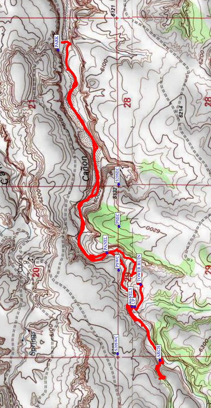
From PARK (0.0 mi) drop into the canyon bottom. (The previous route following the road farther west and walking the trail along the shelf on the north side of the canyon have become washed out and should be avoided.) At PANEL (1.7 mi) high on the east wall there is a spectacular collection of deer, elk, and various symbols to enjoy. Continue upstream to PANELS (2.2 mi) on the north wall and scramble up and view the rock art. Further upstream is a natural ARCH (2.8 mi) entrance to a slot canyon which you can enter and explore. When returning downstream, continue to UP (3.8 mi) and look for the hand and foot holes to ascend the 8 ft high bluff. Look to your left and upwards here, to see another wonderful collection of rock art. Once up the bluff, continue upslope and to your left to TOWER RUIN (4.0 mi). Enjoy and respect all that you see here, and leave no trace of your visit. Leave the ruins going east downward into the arroyo running to the north. Follow the trail downward and into Tapia Canyon near PANEL. Retrace your path back to where you parked.
Often there’s a stop at the Guadalupe RUINS to explore the restored kiva before heading home.
Comments
The land between and north of [PSEC] and [PSWC] is private land. As of May 2009, there is no known method to contact the land owner.
WaypointsAccess
S20SEC: N35 30.074, W107 09.823
S20SWC: N35 30.079, W107 10.882
TURN2PARK: N35 30.912, W107 07.683
Hike
PARK N35 30.383, W107 08.984
PANEL: N35 30.134, W107 10.251
PANELS: N35 30.007, W107 10.588
ARCH: N35 29.862, W107 10.924
UP: N35 29.991, W107 10.590
TOWER RUIN: N35 29.962, W107 10.449
GUADALUPE RUINS: N35 30.988 W107 07.679
Map Filename: TapiaCanyonMap3_MW.jpgHike GPS File Name: TapiaCanyonRev_KSMW.gpx
Hike GPS File: Click link to download hike waytrack file
Additional File 1 Link Click link to download an additional file.
Text Author: Ken Smith
Map Author: Marilyn Warrant
Waypoints Author: Ken Smith
Track Author: Ken Smith
Maintainer: Randy Simons
Editor: Dawn McIntyre