Sandstone Bluffs Long Loop Hike
In El Malpais Region
Map File Source: DeLorme
 Hike Key: H10226
Last Updated: 12/15/2020 12:00am
Last Updated By: Marilyn Warrant
Hike Class: B (Moderate)
Hike Distance: 5 mi
Minimum Elevation: 6670 ft
Elevation Change: 305 ft
Total Uphill: 380 ft
Total Downhill: 380 ft
Avg. Grade: 5 %
Route Type: CCW Loop
On Trail: No
Paved or Gravel Roads: Yes
GPS Advised: Yes
Drive Distance Round Trip: 160 mi
Drive Time One-Way: 1:15
Hiking Seasons: Spring, Fall, and Winter
New Mexico Game Unit: 13
Hike Status: Published
Access Description: El Malpais North Access
Highlights
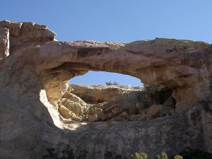
Views of El Malpais lava flows; petroglyphs, great Sandstone Arch.
CautionsNone.
Trailhead Directions
From Albuquerque take I-40 west for about 70 miles to Exit 89 at Grants. Go south on SR 117 for 9 miles to a road on the left where there is a sign for the BLM Visitor Center. Stop there for a break. Then continue south for a few hundred feet to a dirt road on the right marked Sandstone Bluffs. Take this road to a parking area on the right at the top of the hill and PARK (0.0 mi).
Actual Hike
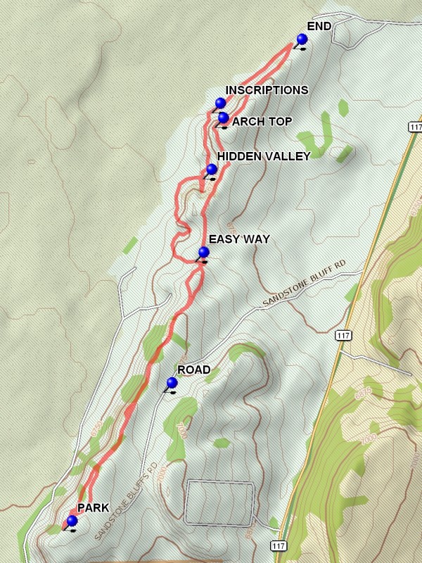
The hike starts at the parking spot. Just west of parking are good views of the bluffs, the El Malpais lava flow, and Gallo Mountain on the west side of the flow. Beyond are the Zuni Mountains. Start the hike by going north along the cliff top. Mount Taylor will be clearly visible to the north. This portion of the hike is about 1.3 miles, with many sandstone formations along the way. On reaching a downed barbed wire fence there is a drop off into the EASY WAY, the easy way to the bottom below the cliffs. Since this description is for a counterclockwise hike the hike continues on top of the ridge. There will be ups and downs as the route continues north. At 2.6 miles from the start there will be a rocky prominence to the west. Near the edge is the top of one of the larger arches in the area. To shorten the hike there is a steep way down is just north of this arch opening. Traverse back and forth to make the descent easier. Otherwise continue north along the top and find a way down to the floor. Do not go further than the END (2.3 mi) since the way will be pinched down by the lava flow. Once down turn back south and find a large rock surface with INSCRIPTIONS (2.8 mi) on it. This is a good stop for lunch if shade is desired. Then go back east and go north through a notch, passing the “foot”. It will be easier to see it as a foot after passing through the notch and looking back north. Look for the arch above at this point. After about 0.2 miles is the entrance to HIDDEN VALLEY (3.1 mi). It is possible to go up this notch to the top of one of the other arches, but continuing north would be difficult. Return to the entrance after going as far as desired. Continue along the base of the cliffs and to the EASY WAY (3.7 mi). If this is missed, there will not be another easy way further south. Once back on top, retrace the route to parking.
Comments
It is possible to go to the [ROAD] and wait for a pickup for anyone too exhausted to continue.
WaypointsROAD: N 34 57.175, W 107 49.871
PARK: N 34 56.693, W 107 50.298
ARCH TOP: N 34 58.101, W 107 49.652
END: N 34 58.375, W 107 49.317
INSCRIPTIONS: N 34 58.151, W 107 49.664
HIDDEN VALLEY: N 34 57.920, W 107 49.702
EASY WAY: N 34 57.631, W 107 49.735
Hike GPS File Name: SandstoneBluffsLongLoopWayTrack_DBDB.gpx
Hike GPS File: Click link to download hike waytrack file
Text Author: Dick Brown
Map Author: Marilyn Warrant
Waypoints Author: Dick Brown
Track Author: Dick Brown
Maintainer: John Cooper
Editor: Marilyn Warrant