Penas Negras – Perchas – Palomas TH Hike
In San Pedro Parks Region
Map File Source: NG Topo
 Hike Key: H10378
Last Updated: 12/05/2023 9:50pm
Last Updated By: Marilyn Fixer
Hike Class: C (Challenging)
Hike Distance: 7.6 mi
Minimum Elevation: 9260 ft
Elevation Change: 821 ft
Total Uphill: 773 ft
Total Downhill: 941 ft
Avg. Grade: 5 %
Route Type: Oneway
On Trail: Yes
Paved or Gravel Roads: Yes
GPS Advised: Yes
Hiker Limit (NF/BLM/NP): 15 (San Pedro Parks Wilderness)
Drive Distance Round Trip: 200 mi
Drive Time One-Way: 2:15
Hiking Seasons: Spring, Summer, and Fall
New Mexico Game Unit: 6A
Hike Status: Published
Access Description: San Pedro Parks Access
Highlights
Chalcedony outcrops, elk sightings, grassy meadows.
CautionsNone.
Trailhead Directions
From Albuquerque take I-25 north to Bernalillo. At Bernalillo take US 550 west to Cuba. From the beginning of Cuba go north 1 mile to SR 126. Turn right and go 13.4 miles to FR 103. Turn left and go 1.7 miles to FR 69. Turn Left and go 5.4 miles to FR 70. turn right and go 1.2 miles to PARK (0.0 mi).
Actual Hike
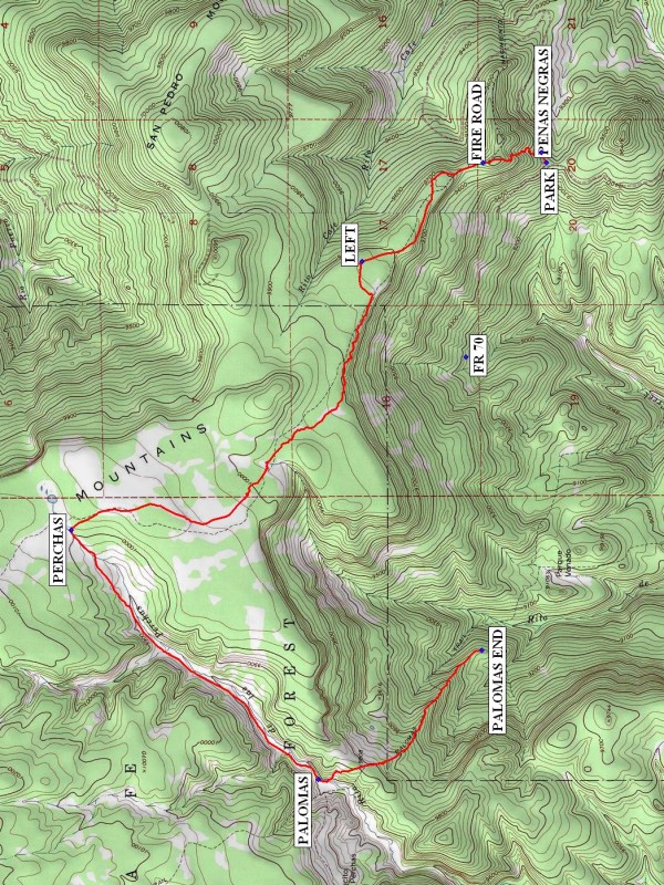
From parking go a short distance up the road to the PENAS NEGRAS (0.1 mi) trailhead on the left. The trail is not heavily traveled but go uphill as the trail becomes better defined. This section of the hike is steep to the FIRE ROAD (0.5 mi). Go left along the mesa going northwest to the LEFT (1.5 mi) point where the trail leaves the fire road. Follow the trail to a swampy area at the trail junction with PERCHAS (4.3 mi) on the left. Perchas trail goes downhill through a cleared valley narrowing as it junctions with PALOMAS (6.3 mi). Take the Palomas trail which rises steeply out of the valley then descends to PALOMAS END (7.6 mi).
Comments
This hike requires a shuttle arrangement or a 4 mile hike back to parking.
Check with ranger station for any road closures. FR 69 may be closed from May 15-Jun 30 for elk calving. Access is available via FR 70 but is a much longer drive.
WaypointsFR 101: N 35 59.178, W 106 47.297
FR 69: N 35 59.734, W 106 46.207
FR 70: N 36 02.649, W 106 45.855
PARK: N 36 02.279, W 106 44.746
PENAS NEGRAS: N 36 02.300, W 106 44.688
FIRE ROAD: N 36 02.573, W 106 44.747
LEFT: N 36 03.132, W 106 45.312
PERCHAS: N 36 04.478, W 106 46.841
PALOMAS: N 36 03.333, W 106 48.266
PALOMAS END: N 36 02.577, W 106 47.528
Hike GPS File Name: PenasNegras-Perchas-PalomasTHWayTrack_DBDB.gpx
Hike GPS File: Click link to download hike waytrack file
Text Author: Dick Brown
Map Author: Marilyn Warrant
Waypoints Author: Dick Brown
Track Author: Dick Brown
Maintainer: Randy Simons
Editor: Marilyn Warrant