Ox Canyon Hike
In Manzano Mountains East Region
Map File Source: NG Topo
 Hike Key: H10171
Last Updated: 12/15/2020 12:00am
Last Updated By: Marilyn Warrant
Hike Class: D (Difficult)
Hike Distance: 8 mi
Minimum Elevation: 8075 ft
Elevation Change: 1585 ft
Total Uphill: 1590 ft
Total Downhill: 1590 ft
Avg. Grade: 9 %
Route Type: InOut
On Trail: Yes
Paved or Gravel Roads: Yes
GPS Advised: No
Drive Distance Round Trip: 160 mi
Drive Time One-Way: 1:15
Hiking Seasons: Spring, Summer, and Fall
New Mexico Game Unit: 14
Hike Status: Published
Highlights
A hike with a gradual, yet steady climb. In the summer you will see a lot of wildflowers. Great views to the east of the salt basins (salinas).
CautionsSome fire damage. The trail is rocky and has steep drop-offs to one side, so take care. Hiking poles recommended.
Trailhead Directions
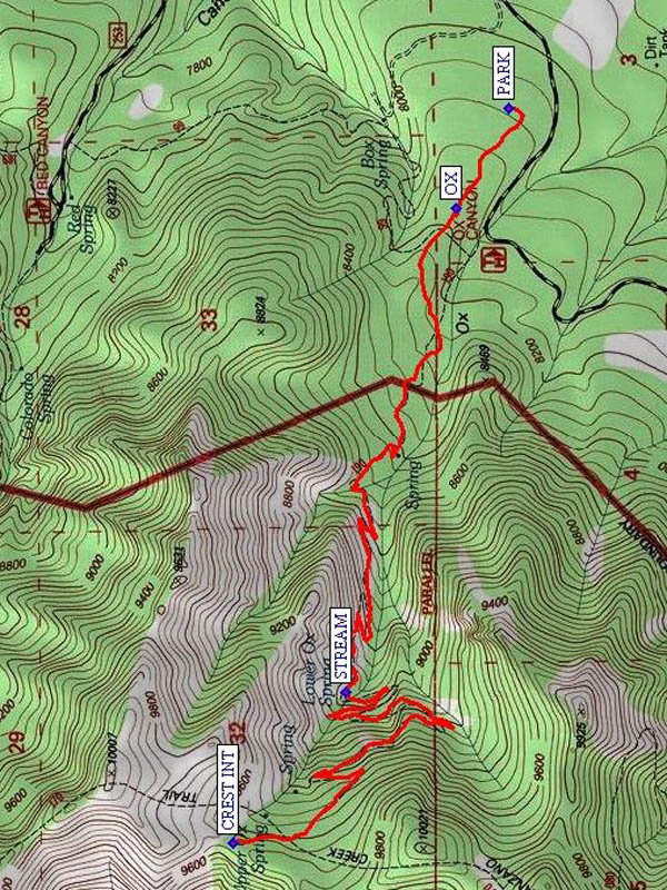
Take Tijeras exit, follow 337 south to 55. Go left (west) on 55 to just past Manzano, follow signs for Red Canyon C.G. I think it is SR 131 at a fork (veer right). At the State Park take right fork. Take FR 253 (gravel) to FR 235, then right on FR 235 to Red Canyon CG and Spruce Spring Trail 189 trailhead. Don’t enter the campground, though. Continue on FR 422 going south to trailhead for Ox Canyon Trail 190 and PARK (0.0 mi).
Actual Hike
From the parking area, go up to the OX (0.3 mi) trailhead. At first you’ll see some evidence of recent fires, but fortunately you pass that quickly. There’s no stream along the trail, but you’ll go by several springs. The Lower Ox Spring may produce enough water for a side STREAM (2.2 mi). There are a number of switchbacks that keep the grade at a steady 9%. Have lunch at the intersection with the Manzano Crest Trail (CREST INT (4.0 mi)) at a lovely meadow. Return the way you came.
Comments
A great hike because it has such a gradual, yet steady climb. In the summer you will see a lot of wildflowers. Great views to the east of the salt basins (salinas). The trail is rocky and has steep drop-offs to one side, so take care.
WaypointsPARK: N 34 36.332, W 106 24.616
OX: N 34 36.449, W 106 24.884
STREAM: N 34 36.696, W 106 26.193
CREST INT: N 34 36.947, W 106 26.600
Hike GPS File Name: OxCanyonWayTrack_MWMW.gpx
Hike GPS File: Click link to download hike waytrack file
Text Author: Roger Holloway
Map Author: Marilyn Warrant
Waypoints Author: Marilyn Warrant
Track Author: Marilyn Warrant
Maintainer: Marilyn Warrant
Editor: Howard Carr