Palomas Peak Two Ways Hike
In Placitas Region
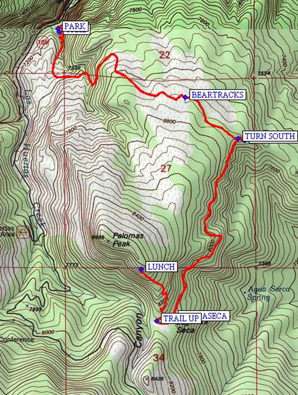
Map File Source: NG Topo
 Hike Key: H10172
Last Updated: 12/15/2020 12:00am
Last Updated By: Marilyn Warrant
Hike Class: D (Difficult)
Hike Distance: 7.1 mi
Minimum Elevation: 7070 ft
Elevation Change: 1450 ft
Total Uphill: 1686 ft
Total Downhill: 1686 ft
Avg. Grade: 13 %
Route Type: InOut
On Trail: No
Paved or Gravel Roads: No
GPS Advised: Yes
Drive Distance Round Trip: 60 mi
Drive Time One-Way: 0:45
Hiking Seasons: Spring, Summer, and Fall
New Mexico Game Unit: 8
Hike Status: Published
Highlights
Challenging hike to Palomas Peak and return.
CautionsSteep terrain. Wear sturdy hiking boots; bring extra water and hiking poles.
Trailhead Directions
From Albuquerque, drive I-25 north to Placitas Exit 242 and go East on NM165 thru the village of Placitas (7 miles) and continue as the road turns south. At mile 9 the pavement ends and becomes a rough gravel road. Continue to mile 11.5 and on the left PARK (0.0 mi) at the Sandia Man Cave parking lot. The trail head (TRHD (0.1 mi)) is just uphill or east of the start point of the trail to the Sandia Man Cave.
Actual Hike
This trail has no Forest Service signs, but it is easy to follow and has diamond shaped blazes marking the way. The trail starts out going south climbing several switchbacks then turns eastward and climbs some more switchbacks. In the first mile, you will have gained some 800 feet elevation, and this section is the steepest part of the hike. The scenery of the northern Sandias to the west is quite nice, and you can see the Penasco Blanco rock bluffs up high on the mountain. Continue eastward and enjoy views to the north and east where you can see Peralta Canyon and its Tent Rocks up in the Jemez Mountains. Part of the trail here is shaded by White Fir trees and Pinyon and Ponderosa Pines. In May 2009, I saw turkey tracks and bear tracks in this stretch (BEARTRACKS (1.4 mi)) and there was a lot of white blooming Cliff Fendler Bush. At about the 1.75 mile point, the trail takes a sharp turn to the south and there are nice views to the east (TURN SOUTH (1.7 mi)). This eastern side of the peak is warmer and is mostly Pinyon and Juniper trees. In May, there were blooming yucca, penstemon, Indian paintbrush, verbena, and desert marigold to see along the way. At the 3 mile mark, and at 8100 feet elevation, you will enter a nice meadow area named Lagunita Seca (LAGNASECA (3.1 mi)). On the southeastern corner of the meadow, the North Mystery trail goes south, and on the northwestern corner there is a trail going down to a small parking area on NM165. At this same northwestern corner of the meadow, there is a trail going up (TRAIL UP (3.1 mi)) the south side of the peak to a rock climbing area. It is about 0.5 mile and 400 feet elevation gain to the climbing area (8500 ft) which has overhanging cliffs and the deep shade there, and is a good place for LUNCH (3.5 mi). Alternately, if you have had enough steep trail for your day, have your lunch on the east side of the meadow under the large trees. When ready to go back, return to the northeastern corner of the meadow and retrace your steps back to the parking area at Sandia Man Cave.
Comments
Please respect the elevation gain and the steep terrain on this trail. To complete this hike, you will need sturdy hiking boots, strong lungs and legs and at least 2 canteens of water. If time and energy permit, visit the cave which is about 0.5 mile walk on a level trail north of the parking lot. I suggest you drop your packs at the bottom of the steep narrow spiral stairs which take you up to the cave entrance. Carry a small flashlight if you plan on going into the cave.
WaypointsPARK: N 35 15.007, W 106 24.612
TRHD: N 35 14.990, W 106 24.605
BEARTRACKS: N 35 14.694, W 106 23.908
TURN SOUTH: N 35 14.507, W 106 23.613
VIEW POINT: N 35 14.497, W 106 23.578
LAGNASECA: N 35 13.691, W 106 23.971
TRAIL UP: N 35 13.680, W 106 24.062
LUNCH: N 35 13.914, W 106 24.149
Hike GPS File Name: PalomasPeakTwoWaysWayTrack_KSKS.gpx
Hike GPS File: Click link to download hike waytrack file
Text Author: Ken Smith
Map Author: Ken Smith
Waypoints Author: Ken Smith
Track Author: Ken Smith
Maintainer: Ken Smith
Editor: Marilyn Warrant