Mesa Penistaja Short Loop Hike
In Cuba Region
Map File Source: DeLorme
 Hike Key: H10549
Last Updated: 03/11/2021 12:00am
Last Updated By: Carl Gervais
Hike Class: B (Moderate)
Hike Distance: 4.3 mi
Minimum Elevation: 6935 ft
Elevation Change: 170 ft
Total Uphill: 300 ft
Total Downhill: 300 ft
Avg. Grade: 5 %
Route Type: CW Loop
On Trail: No
Paved or Gravel Roads: No
GPS Advised: Yes
Drive Distance Round Trip: 190 mi
Drive Time One-Way: 1:45
Hiking Seasons: Spring, Fall, and Winter
New Mexico Game Unit: 7
Hike Status: In Process
Highlights
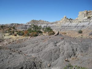
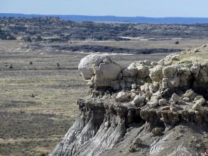
There are numerous badlands formations and pieces of petrified wood. The highlight is a very large box canyon with a large collection of petrified wood and spires on the surrounding sides.
CautionsThis hike is off trail and hiking poles are suggested. The use of a GPS is recommended for leading this hike.
Trailhead Directions
From Albuquerque take I-25 north to Bernalillo. At Bernalillo take US 550 west to the intersection with SR 197 in Cuba. Turn left and drive 9 miles to the DIRT road at the bend in SR 197. Turn right onto the dirt road which immediately turns left and heads west. Drive 7.2 miles to LOVINO WOODS road on the right. Turn right and go 1.7 miles to a two track on the left side of the road. PARK (0.0 mi) here.
Actual Hike
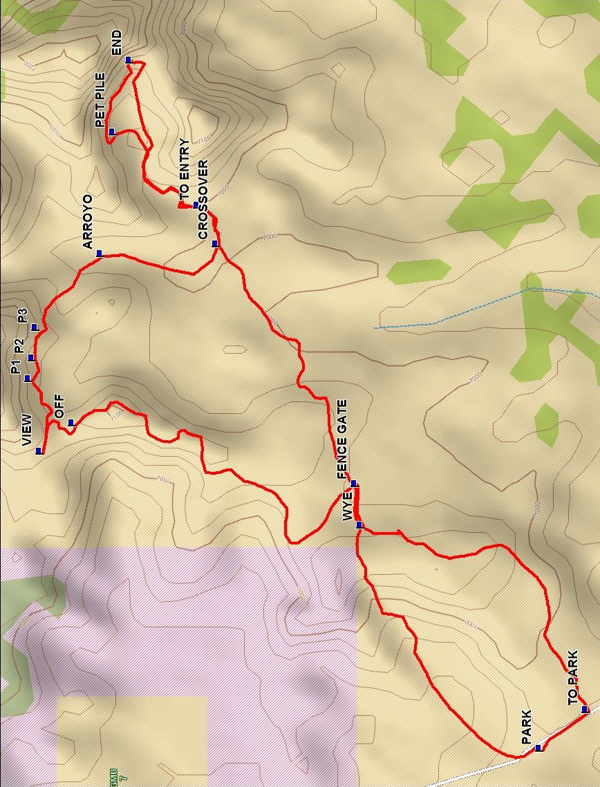
Walk north on the road to a two track on the right and go right. Follow this two track up to the ridge to the east and on to the FENCE GATE (0.6 mi). Go through the fence gate and go northwest along the fence to an edge and go north along the edge to OFF (1.3 mi) and descend to the area below. Continue north until blocked by a mesa and go west to VIEW (1.5 mi).
Then return and go east along the bottom of the mesa to the north and enjoy P1 (1.6 mi), P2 (1.6 mi), and P3 (1.7 mi). After P3 go over a small ridge and descend into a wash and follow the wash to a main arroyo at ARROYO (1.9 mi) and turn right, going down the arroyo until you reach TO ENTRY (2.2 mi). Leave the arroyo on the left and go down the slope to the small arroyo and follow this arroyo as it narrows and winds its way into the box canyon. Keep to the left and go to the PET PILE (2.4 mi) a very large collection of petrified wood.
After enjoying the wood go along the left side of the canyon to END (2.6 mi) where you may want to search for a geocache here. Then turn right and drop down into the small stream bed and go back towards the mouth of the canyon, through the entry and to the CROSSOVER (3.0 mi) point where you left the arroyo and follow the track southwest and up onto the low mesa and continue to the FENCE GATE. Follow the two track TO PARK (4.3 mi) and turn right on the road and walk the road back to parking.
Waypoints
Access
DIRT: N 35 57.382, W 107, 05.520
LOVINO WOODS: N35 57.424, W107 13.180
Hike
PARK: N 35 58.847, W 107 13.545
WYE: N35 59.107, W107 13.145
FENCE GATE: N35 59.115, W107 13.070
OFF: N35 59.526, W107 12.960
VIEW: N35 59.573, W107 13.011
P1: N35 59.589, W107 12.881
P2: N35 59.584, W107 12.844
P3: N35 59.579, W107 12.789
ARROYO: N35 59.485, W107 12.657
CROSSOVER: N35 59.317, W107 12.639
TO ENTRY: N35 59.344, W107 12.570
PET PILE: N35 59.466, W107 12.437
END: N35 59.443, W107 12.309
TO PARK: N35 58.779, W107 13.476
Hike GPS File Name: MesaPenistajaShortLoopWayTrack_DBDB.gpx
Hike GPS File: Click link to download hike waytrack file
Text Author: Dick Brown
Map Author: Marilyn Warrant
Waypoints Author: Dick Brown
Track Author: Dick Brown
Maintainer: Carl Gervais
Editor: Howard Carr