Mano Trail – Sandia Eye Loop Hike
In Sandia Mountain West Region
Map File Source: NG Topo
 Hike Key: H10413
Last Updated: 03/20/2023 2:32pm
Last Updated By: Marilyn Fixer
Hike Class: D (Difficult)
Hike Distance: 6.5 mi
Minimum Elevation: 6182 ft
Elevation Change: 1220 ft
Total Uphill: 1865 ft
Total Downhill: 1865 ft
Avg. Grade: 12 %
Route Type: CW Loop
On Trail: No
Paved or Gravel Roads: Yes
GPS Advised: Yes
Hiker Limit (NF/BLM/NP): 15 (Sandia Wilderness)
Drive Distance Round Trip: 20 mi
Drive Time One-Way: 0:45
Hiking Seasons:
New Mexico Game Unit: 8
Hike Status: Published
Highlights
Panoramic views to the west.
CautionsA steep hike; trekking poles recommended.
Trailhead Directions
PARK-EMB (0.0 mi) in the lot at the East end of Indian School Rd at the Embudo trailhead.
Actual Hike
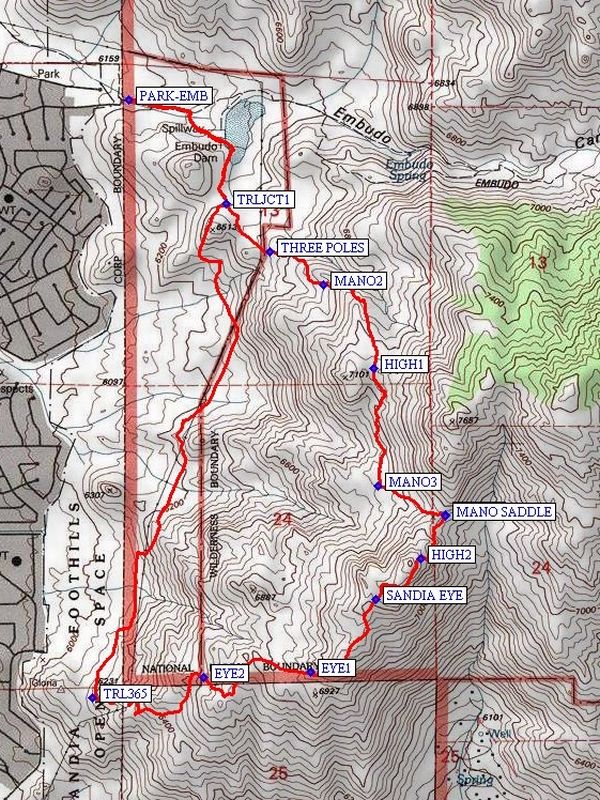
Take Embudo Trail east toward the Dam. At 0.21 miles, cut over to the right and work your way to the top of the Dam. Turn right (south) and walk uphill through a break in the fence line. Proceed south on this well traveled trail until you reach a brown sign marked 365, TRLJCT1 (0.61 mi). Go left (southeast) (not up the hill) to second brown 365 sign – stay to the right. Follow this trail to a set of three poles supporting the power line at THREE POLES (0.85 mi, 6250′). This is the start of the Mano Trail. Proceed east and up a steep grade. The trail turns to the south and then to the southeast to a critical waypoint MANO2 (1.1 mi, 6720′). Here, the trail appears to go south, but stay to the left and head northeast and eventually southeast up a steep hill to HIGH1 (1.5 mi, 7060′). Follow trail south across a wide, flat, open area that has panoramic views, including Albuquerque laid out to the west. At 1.65 mi, the trail begins its descent south into the canyon and then climbs the slope on the other side. This route is interesting, snaking up and down hill, over and between boulders, has segments of loose pebbles, and is bordered by a variety of cacti, shrubs, and grasses. On the far side of the canyon, follow trail south on a broad plateau to where it intersects with a heavily – used cross trail (running east – west) at MANO3 (2 mi). Turn east and follow the Mano Route for a 0.2 mi, moderate ascent up to MANO SADDLE (2.27 mi, 7175′). There is a single, alligator juniper tree here as well as nice vistas in all directions. Turn south and hike up to a pile of boulder rocks; stay on east side of rocks. Be alert for a trail leading you to a staircase pattern upward; there is only one unusually large rock to hoist oneself over. You will want to be on the northern end of the pile; look for a well-worn trail as you reach HIGH2 (2.47 mi, 7407′), and follow it to west side of the boulders, and skirt around the boulders to the south. Panoramic views greet the hiker here — South Peak to the northeast, Manzano Mountain peaks, I-40 corridor, the Ladrones to the south, and various landmarks to the west. Continue southwest on trail to SANDIA EYE (2.65 mi, 7260′). This is a good lunch spot while enjoying the view to the south. After lunch, continue going southwest on the trail to EYE1 (3.15 mi). Then go west. At a fork in the trail, go right (southwest) to EYE2 (3.5 mi); go straight (south) and then, turn right (west), and follow distinct trail up to the top of the hill where there is a set of three poles supporting the power line. From there, continue on trail down to a junction with TRL365 (4.1 mi). Go north on trail 365 all the way until you reach TRLJCT1 where the brown signs marked 365 are, marking the end of the balloon loop. Return to the Embudo Trailhead parking area using same route as the start of the hike.
Waypoints
PARK-EMB: N35 05.945 W106 28.817 (0.0 mi)
TRLJCT1: N35 05.660 W106 28.491 (0.61 mi)
THREE POLES: N35 05.527 W106 28.344 (0.85 mi)
MANO2: N35 05.435 W106 28.166 (1.1 mi)
HIGH1: N35 05.209 W106 27.997 (1.5 mi)
MANO3: N35 04.886 W106 27.983 (2 mi)
MANO SADDLE: N35 04.803 W106 27.759 (2.27 mi)
HIGH2: N35 04.687 W106 27.843 (2.47 mi)
SANDIA EYE: N35 04.574 W106 27.991 (2.65 mi)
EYE1: N35 04.374 W106 28.209 (3.15 mi)
EYE2: N35 04.361 W106 28.568 (3.5 mi)
TRL365: N35 04.303 W106 28.936 (4.1 mi)
Hike GPS File Name: ManoTrail-SandiaEyeLoopWayTrack_DV.gpx
Text Author: Bill Davidson
Map Author: Marilyn Warrant
Waypoints Author:
Track Author:
Maintainer: Not Assigned
Editor: Howard Carr