Los Pinos To San Pedro Cabin Hike
In San Pedro Parks Region
Map File Source: DeLorme
 Hike Key: H10386
Last Updated: 12/15/2020 12:00am
Last Updated By: Marilyn Warrant
Hike Class: E (Most difficult)
Hike Distance: 11.9 mi
Minimum Elevation: 8180 ft
Elevation Change: 2260 ft
Total Uphill: 2300 ft
Total Downhill: 2300 ft
Avg. Grade: 9 %
Route Type: InOut
On Trail: Yes
Paved or Gravel Roads: Yes
GPS Advised: Yes
Hiker Limit (NF/BLM/NP): 15 (San Pedro Parks Wilderness)
Drive Distance Round Trip: 180 mi
Drive Time One-Way: 2:00
Hiking Seasons: Summer and Fall
New Mexico Game Unit: 6A
Hike Status: Published
Access Description: San Pedro Parks Access
Highlights
A strenuous hike to San Pedro Parks. Babbling brook, lush forest, San Pedro Cabin Ruin.
CautionsSteep (14% grade) on the way to the Parks. Hiking poles recommended.
Trailhead Directions
From Albuquerque take I-25 north to Bernalillo exit 242, west on US 550 to Cuba. From the Cuba Ranger Station go north 1.6 miles to Los Pinos Rd. Turn right and go 4.2 miles to FR 95. Turn right and go 3.2 miles to LOS PINOS PARK (0.0 mi).
Actual Hike
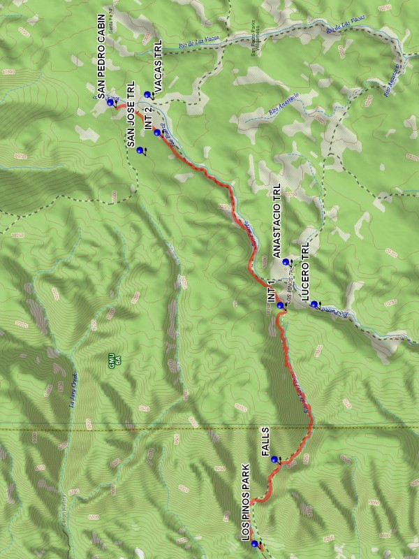
From Parking follow the Los Pinos Trail. The grade over the first three miles is 14%. This is the hardest part of the hike. At the end of this section arrive at INT 1 (3.3 mi). ANASTACIO TRL goes east from this point while LUCERO TRL goes southeast. Los Pinos turns north and the rise in elevation is more gradual. Along this section there are pleasant open areas and a babbling brook. At INT 2 (5.5 mi) Los Pinos ends. The actually non-existent SAN JOSE TRL goes west. VACAS TRL starts here and goes east. Continue north, this is the famous San Pedro Parks, a large open area with, what! Numerous grazing cattle. Eventually SAN PEDRO CABIN (6.0 mi) will come into view to the west. Then you are there. After inspecting the ruins turn around and go back, mostly downhill.
Waypoints
ANASTACIO TRL: N 36 05.944, W 106 51.587
LUCERO TRL: N 36 05.718, W 106 52.003
SAN JOSE TRL: N 36 07.107, W 106 50.487
VACAS TRL: N 36 07.045, W 106 49.938
LOS PINOS PARK: N 36 06.192, W 106 54.362
FALLS: N 36 06.034, W 106 53.529
INT 1: N 36 05.989, W 106 52.016
INT 2: N 36 06.967, W 106 50.311
SAN PEDRO CABIN: N 36 07.340, W 106 50.019
Hike GPS File Name: LosPinosToSanPedroCabinWayTrack_DBDB.gpx
Hike GPS File: Click link to download hike waytrack file
Text Author: Dick Brown
Map Author: Marilyn Warrant
Waypoints Author: Dick Brown
Track Author: Dick Brown
Maintainer: Not Assigned
Editor: Howard Carr