Las Conchas – Box – East Fork Wade Hike
In Jemez Mountains Region
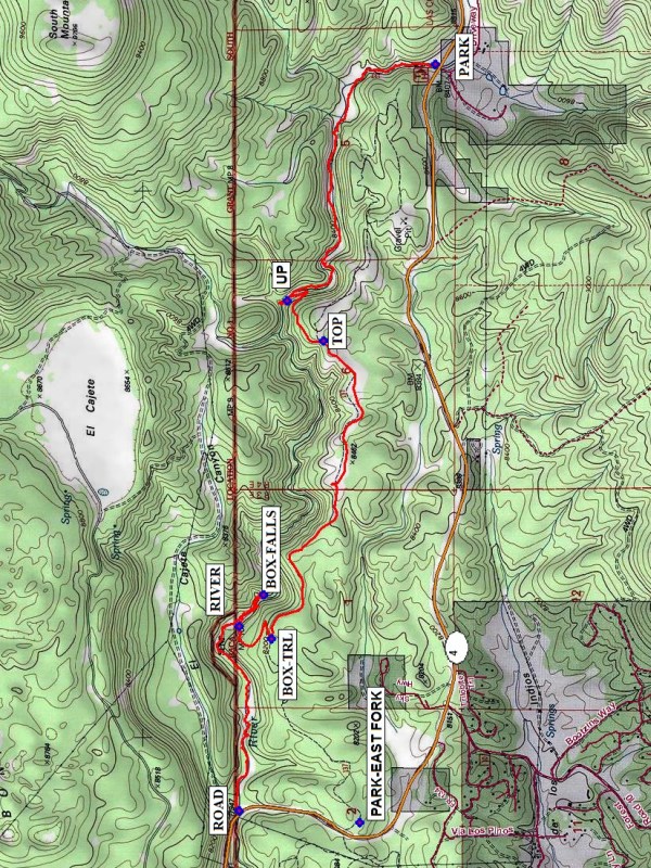
Map File Source: NG Topo
 Hike Key: H10402
Last Updated: 12/15/2020 12:00am
Last Updated By: Marilyn Warrant
Hike Class: B (Moderate)
Hike Distance: 5.5 mi
Minimum Elevation: 7956 ft
Elevation Change: 618 ft
Total Uphill: 420 ft
Total Downhill: 868 ft
Avg. Grade: 7 %
Route Type: Oneway
On Trail: No
Paved or Gravel Roads: Yes
GPS Advised: Yes
Drive Distance Round Trip: 160 mi
Drive Time One-Way: 2:00
Hiking Seasons: Spring, Summer, and Fall
New Mexico Game Unit: 6A
Hike Status: Published
Highlights
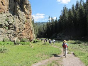
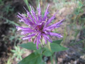
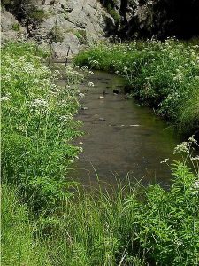
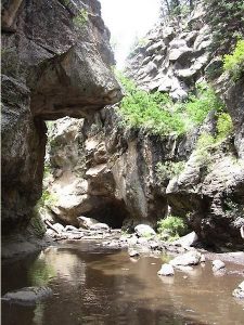
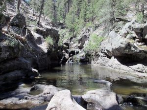
Mountain stream in narrow canyon; many river crossings. Incredible rock formations, wildflowers in summer, good aspen fall color. On a hot summer day, wading in the river is delightfully refreshing.
CautionsBring water shoes and trekking poles for river crossings. Some steep uphill and downhill sections.
Trailhead Directions
I-25 N to exit 242, W on US 550 to San Ysidro, right (north) on SR 4 to La Cueva. Take SR 4 12.4 mi. east of La Cueva to Las Conchas C.G. Drop off the hikers here, drive both vehicles to PARK-EAST FORK, leave one vehicle there, and drive the other back to PARK (0.0 mi). (The local sheriff is ticketing any vehicles parked at the turnout at ROAD.)
Actual Hike
The first part of the hike is a mile walk down Las Conchas Canyon. This small canyon is very scenic. There are many crossings of the river on this part, all of them rebuilt as real foot bridges. From UP (1.7 mi), take a trail to your left and climb up to TOP (2.1 mi). On trail 137, go gradually downhill to BOX TRAIL (3.8 mi) then steeply down to the RIVER (4.2 mi) again. Here you’ll have the option to wade up to the BOX-FALLS (4.55 mi), a series of cascading waterfalls and deep pools, or stay by the river where you are for lunch. Then continue downstream with multiple river crossings back to the ROAD (5.8 mi). The drivers will need to hike about 0.5 mi uphill to PARK-EAST FORK to retrieve the first vehicle, drive back to PARK for the second vehicle, then pick up the hikers at ROAD.
Comments
There’s lots of wading on this hike, so bring your water shoes. Hiking sticks will help on the steep parts of the hike and the river crossings. There are some deep pools on the way to the Box, so roll-up pants or those with removable lower legs are advised, or wear your bathing suit under your clothes. There are incredible rock formations, fields of wildflowers in the summer, and aspens for fall color. Runoff from the Las Conchas fire burn scar has resulted in some black mud, but it’s still a beautiful hike. Keep an eye out for the potential for flash flooding if you go during the monsoon season.
The grade given in the hike data is the grade averaged over the entire hike, which is mostly flat. Hikers who usually can do B hikes may have a problem with this one, since the uphill and downhill portions are so steep (20% grade).
WaypointsPARK-EAST FORK: N35 49.202, W106 35.432
PARK: N35 48.921, W106 31.970
UP: N35 49.472, W106 33.048
TOP: N35 49.338, W106 33.232
BOX-TRL: N35 49.531, W106 34.594
RIVER: N35 49.649, W106 34.534
BOX-FALLS: N35 49.560, W106 34.391
ROAD: N35 49.649, W106 35.378
Hike GPS File Name: LasConchas-Box-EastForkWadeWayTrack_MW.gpx
Hike GPS File: Click link to download hike waytrack file
Text Author: Vivian Heyward
Map Author: Marilyn Warrant
Waypoints Author: Marilyn Warrant
Track Author: Marilyn Warrant
Maintainer: Vivian Heyward
Editor: Howard Carr