La Leña East By Southeast Loop Hike
In Cabezon Region
Map File Source: DeLorme
 Hike Key: H10507
Last Updated: 03/23/2021 12:00am
Last Updated By: Marilyn Fixer
Hike Class: B (Moderate)
Hike Distance: 5.8 mi
Minimum Elevation: 6250 ft
Elevation Change: 140 ft
Total Uphill: 145 ft
Total Downhill: 145 ft
Avg. Grade: 3 %
Route Type: CCW Loop
On Trail: No
Paved or Gravel Roads: No
GPS Advised: Yes
Drive Distance Round Trip: 150 mi
Drive Time One-Way: 1:45
Hiking Seasons: Spring, Fall, and Winter
New Mexico Game Unit: 7
Hike Status: Published
Access Description: Cabezon Area Access
Highlights
A magnificent view into the largest drainage south of San Luis mesa.
CautionsNone.
Trailhead Directions
From Albuquerque take I-25 north to Bernalillo. At Bernalillo take US 550 to San Ysidro. Drive west 18 mi. past intersection of SR 4 and US 550 in San Ysidro to San Luiz Rd (aka CR 279). Turn left and drive 12 mi. on San Luis Road (past Torreon Rd.), veer to the right at JCTBLM1114 then turn right at JCTBLM1102 after another 2 mi. Go uphill for another 3.2 mi, and PARK on the east side of the road. Please do not block the cattle expressway.
Actual Hike
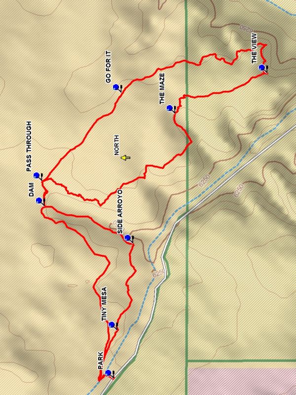
Take the cattle expressway east. After about 200 feet you will encounter an arroyo blocking your way. But trust the cattle express way which slants down into the arroyo the up the other side. Turn right and follow the edge of the arroyo to the TINY MESA (0.3 mi) which you ascend for a view of the area. Then continue along the arroyo to the SIDE ARROYO (0.8 mi) which you go down into and go left up the arroyo. Eventually you reach a broken dam which you go up onto and to the right. Continue up to the PASS THROUGH (1.4 mi) and then go along the east side ot the side canyon and then south until a deep side canyon confronts you where you head for THE MAZE (2.4 mi). Once through the maze go toward THE VIEW (3.0 mi) where you suddenly encounter an awesome view of a huge north/south drainage arroyo. Stop here to enjoy the view and perhaps lunch. Then head north along the west side of the drainage arroyo to GO FOR IT (4.0 mi) and endure the trek back to the dam where you might engage the local cattle. Follow the edge of the side arroyo, returning to the arroyo cross through, and back to parking.
Comments
The destination of this hike is to a view into the largest drainage arroyo south of San Luis Mesa and has views down the Rio Puerco Valley and of the ever present Cabezon plug. The use of a GPS is recommended for this hike.
WaypointsJCTBLM1102: N 35 38.128, W 107 07.927
JCTBLM1114: N 35 37.933, W 107 06.487
PARK: N 35 40.346, W 107 10.045
TINY MESA: N 35 40.332, W 107 09.812
SIDE ARROYO: N 35 40.271, W 107 09.392
DAM: N 35 40.615, W 107 09.211
PASS THROUGH: N 35 40.624, W 107 09.090
THE MAZE: N 35 40.108, W 107 08.763
THE VIEW: N 35 39.751, W 107 08.569
GO FOR IT: N 35 40.317, W 107 08.663
Hike GPS File Name: LaLenaEastBySoutheastLoopWayTrack_DBDB.gpx
Hike GPS File: Click link to download hike waytrack file
Text Author: Dick Brown
Map Author: Dick Brown
Waypoints Author: Dick Brown
Track Author: Dick Brown
Maintainer: Carl Gervais
Editor: Howard Carr