Lower San Antonio to Cave Hike
In Jemez Mountains Region
Map File Source: NG Topo
 Hike Key: H10510
Last Updated: 12/15/2020 12:00am
Last Updated By: Marilyn Warrant
Hike Class: C (Challenging)
Hike Distance: 6.4 mi
Minimum Elevation: 7788 ft
Elevation Change: 800 ft
Total Uphill: 852 ft
Total Downhill: 852 ft
Avg. Grade: 9 %
Route Type: Lollypop
On Trail: Yes
Paved or Gravel Roads: Yes
GPS Advised: Yes
Drive Distance Round Trip: 110 mi
Drive Time One-Way: 1:15
Hiking Seasons: Spring, Summer, and Fall
New Mexico Game Unit: 6A
Hike Status: Published
Highlights
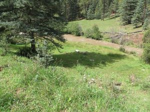
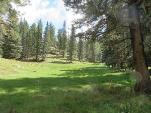
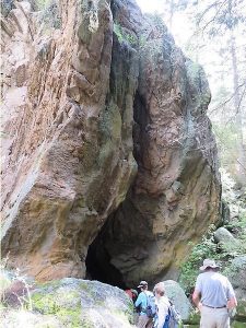
Acres of wildflowers in the meadows and some fish to be seen in the creek. Also a cave.
CautionsNone.
Trailhead Directions
From Albuquerque, take I-25 north to Bernalillo. From Bernalillo take US 550 west to San Ysidro. Take SR 4 north to La Cueva. Turn left (west) on SR 126. In approximately 2 miles just past the entrance to the San Antonio campground, turn right and cross the cattle guard through a Forest Service gate and park along the fence line. This area is across the street from the western end of the San Antonio campground.
Actual Hike
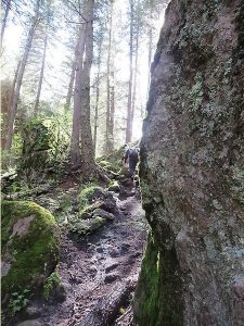
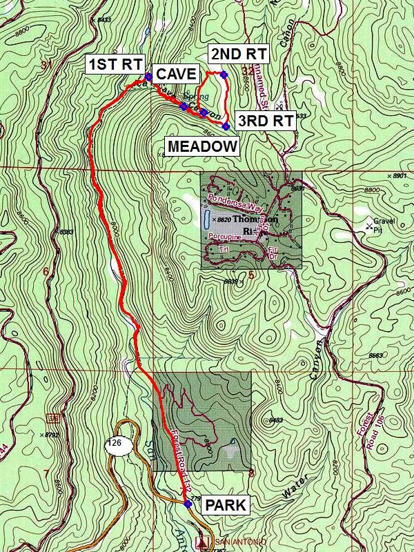
From PARK (0.0 mi.), hike north on the dirt road parallel with the eastern side of San Antonio Creek. Where the road ends, cross a small stream and head to the right up the hill to 1ST RT (2.5 mi.) and uphill (that parallels Cave Canyon with a small stream) to CAVE (2.7 mi.). After exploring the small cave, proceed uphill to a beautiful small MEADOW (2.9 mi.) for lunch. After lunch, hike north up the old logging road. Continue hiking uphill and then southeast downhill to 2ND RT (3.4 mi.). This is in a long meadow with a dirt road. Hike south on the dirt road to 3RD RT (3.7 mi.), turning right and hiking westerly through the first meadow down hill past the CAVE to the main trail. At the main trail, turn left and backtrack southerly to PARK.
Comments
This hike is best in the late spring and early summer when there are acres of wildflowers in the meadows and some fish to be seen in the creek. Ted Cooley’s research revealed the San Antonio Creek functions as the west fork of the Jemez River. He discovered the cave is deep enough to get beyond the twilight zone and thus qualifies as a cave (even though not very deep). He further states it might fall into the rare category of a fissure or joint cave where two sections of the welded tuff of the Jemez eruption joined leaving a weak area which formed the cave.
WaypointsPARK: N35 53.397, W106 38.891
1ST RT: N35 55.213, W106 39.098
CAVE: N35 55.087, W106 38.915
MEADOW: N35 55.061, W106 38.810
2ND RT: N35 55.221, W106 38.705
3RD RT: N35 55.001, W106 38.694
Hike GPS File Name: LowerSanAntonioToCaveWayTrack_FE.gpx
Hike GPS File: Click link to download hike waytrack file
Text Author: Frank Ernst
Map Author: Marilyn Warrant
Waypoints Author: Frank Ernst
Track Author: Frank Ernst
Maintainer: Frank Ernst
Editor: Howard Carr