La Cueva – La Luz Scenic Loop Hike
In Sandia Mountain West Region
Map File Source: NG Topo
 Hike Key: H10414
Last Updated: 03/20/2023 2:30pm
Last Updated By: Marilyn Fixer
Hike Class: D (Difficult)
Hike Distance: 7.8 mi
Minimum Elevation: 6553 ft
Elevation Change: 2044 ft
Total Uphill: 2076 ft
Total Downhill: 2076 ft
Avg. Grade: 12 %
Route Type: Loop
On Trail: Yes
Paved or Gravel Roads: Yes
GPS Advised: Yes
Hiker Limit (NF/BLM/NP): 15 (Sandia Wilderness)
Drive Distance Round Trip: 32 mi
Drive Time One-Way: 0:30
Hiking Seasons: Spring and Fall
New Mexico Game Unit: 8
Hike Status: Published
Highlights
A strenuous hike on parts of both the new and old La Luz trails up to the Cave.
CautionsSteep, so hiking poles recommended.
Trailhead Directions
In Albuquerque go north on Tramway Blvd to Forest Hwy 333, the road to the La Luz trailhead. Follow 333 northeast for a short distance, following the signs to the La Cueva Picnic Area, and PARK (0.0 mi). A three dollar fee or Golden Age Pass is required to park here.
Actual Hike
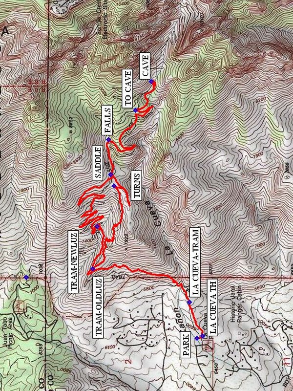
From parking, go up the La Cueva Trail from LA CUEVA TH (0.0 mi) to the intersection with the Tramway Trail (LA CUEVA-TRAM). Go left (north) on the Tramway Trail to its intersection with the Old La Luz Trail (TRAM-OLDLUZ (1.0 mi)). From here until you start the TURNS (1.8 mi) is the steepest part of the hike (18% grade). Join the new La Luz trail at the SADDLE (2.2 mi), and continue up that trail past the FALLS (2.4 mi) until you reach TO CAVE (3.2 mi). Leave the new La Luz Trail and rejoin the old La Luz Trail here, and go up to the CAVE (3.4 mi). On the return trip, at the SADDLE stay on the new La Luz Trail until you come to the intersection of the Tramway Trail with the new La Luz Trail at TRAM-NEWLUZ (6.2 mi). Continue south on the Tramway Trail to the short La Cueva Trail back to the van.
Waypoints
LA CUEVA TH: N 35 12.267, W 106 29.232
PARK: N 35 12.297, W 106 29.247
LA CUEVA-TRAM: N 35 12.333, W 106 29.016
TRAM-OLDLUZ: N 35 12.837, W 106 28.804
TURNS: N 35 12.725, W 106 28.278
SADDLE: N 35 12.745, W 106 28.209
FALLS: N 35 12.757, W 106 27.986
TO CAVE: N 35 12.614, W 106 27.799
CAVE: N 35 12.533, W 106 27.617
TRAM-NEWLUZ: N 35 12.815, W 106 28.536
Hike GPS File Name: LaCueva-LaLuzScenicLoopWayTrack_DVDV.gpx
Hike GPS File: Click link to download hike waytrack file
Text Author: Bill Davidson
Map Author: Marilyn Warrant
Waypoints Author:
Track Author:
Maintainer: Not Assigned
Editor: Marilyn Warrant