Dinosaur Dig Hike
In Ojito Region
Map File Source: NG Topo
 Hike Key: H10158
Last Updated: 12/15/2020 12:00am
Last Updated By: Marilyn Warrant
Hike Class: B (Moderate)
Hike Distance: 2.6 mi
Minimum Elevation: 5706 ft
Elevation Change: 206 ft
Total Uphill: 325 ft
Total Downhill: 325 ft
Avg. Grade: 7 %
Route Type: Loop
On Trail: No
Paved or Gravel Roads: No
GPS Advised: Yes
Drive Distance Round Trip: 72 mi
Drive Time One-Way: 1:15
Hiking Seasons: Spring, Fall, and Winter
New Mexico Game Unit: 9
Hike Status: Published
Access Description: Ojito Wilderness Area Access
Highlights
Seismosaurus discovered here in 1979. Beautiful petroglyphs in the area.
CautionsNone.
Trailhead Directions
I-25 north to exit 242. West on US 550 to milepost 21. Turn left at sign for Cabezon Rd. Go through the gate (ignore Zia Pueblo, No Trespassing sign). Check odometer, the destination is 10.5 miles from here. The road forks immediately. Take the left fork (Cabezon Rd.) and not the right one (White Mesa). Cabezon Rd. goes thru Zia land, then at the cattle crossing enters Public Land. The road is slick and dangerous when wet. Drive about 10.5 miles to a “Parking Area” sign. PARK (0.0 mi) on left there, cross road and enter at the iron gate.
Actual Hike
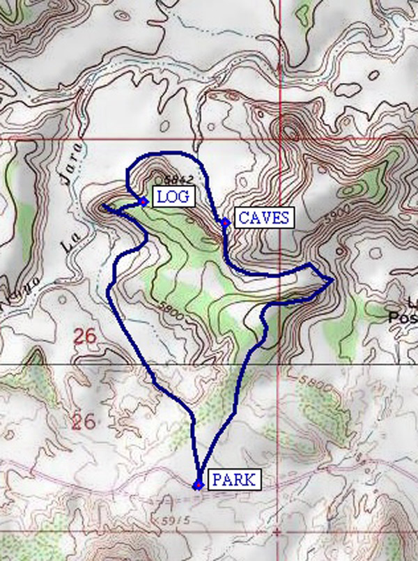
Hike follows road right to the dig and is only a little over a mile making a big curve to the left. The road ends there at the dig. We prefer a longer hike and instead of going directly to the dig, turn right off the road and go northeast up along a rocky ridge and descend the other side. Follow arroyo west and down a narrow and rocky area to some interconnected CAVES (1.1 mi). Very unusual rocks here with smooth round holes through them. Continue around to the west side of the mesa past a petrified LOG (1.6 mi) and climb up the long, gradual draw to the DIG (1.7 mi) site. You can see your vehicle from there. You can go back by the road or extend hike by descending into valley (interesting erosion effects). Hike back to parking area.
Comments
A 90 ton, 130′ long, 154 million-year old seismosaurus was discovered and taken from here in 1979 and is being restored in Albuquerque’s Nat. Hist. Museum. You’ll find nice petroglyphs west of the sandy dig area. There is a small cave directly below the petroglyphs for the adventurous. You’ll find dagger cactus, black lichen on ground, hard mud that looks like coral, huge rocks perched atop columns of hard mud.
WaypointsPARK: N 35 29.738, W 106 54.391
CAVES: N 35 30.320, W 106 54.319
LOG: N 35 30.367, W 106 54.541
DIG: N 35 30.353, W 106 54.653
Hike GPS File Name: DinosaurDigWayTrack_JBJB.gpx
Hike GPS File: Click link to download hike waytrack file
Text Author: Roger Holloway
Map Author: John Boyd
Waypoints Author: John Boyd
Track Author: John Boyd
Maintainer: Bill Gloyd
Editor: Howard Carr