Corrales Lateral South Hike
In Corrales Region
Map File Source: DeLorme
 Hike Key: H10456
Last Updated: 03/04/2021 12:00am
Last Updated By: Marilyn Fixer
Hike Class: A (Easy)
Hike Distance: 4.2 mi
Minimum Elevation: 5003 ft
Elevation Change: 10 ft
Total Uphill: 10 ft
Total Downhill: 10 ft
Avg. Grade: %
Route Type: InOut
On Trail: Yes
Paved or Gravel Roads: Yes
GPS Advised: No
Drive Distance Round Trip: 20 mi
Drive Time One-Way: 0:30
Hiking Seasons: Spring, Summer, Fall, and Winter
New Mexico Game Unit: 9
Hike Status: Published
Highlights
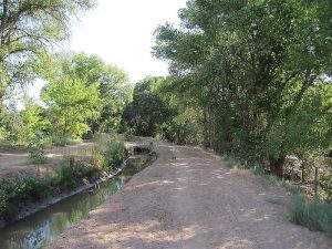
Short easy hike along the shady Corrales Lateral drainage ditch.
CautionsNone.
Trailhead Directions
From Alameda and I-25, proceed west on Alameda to Corrales Road. Go northeast on Corrales Rd. approximately 2.5 mi. and turn left on West Ella. PARK (0.0 mi) in the parking lot for the Corrales Professional Offices building at 4481 Corrales Rd. in the shade facing the street or in the back of the building (check with Community Sciences Corp. at 897-0000, Extn 119 beforehand to make sure that’s still OK). Alternatively, if you’re going to the Hannah & Nate’s restaurant afterwards, you could park in the restaurant parking lot.
Actual Hike
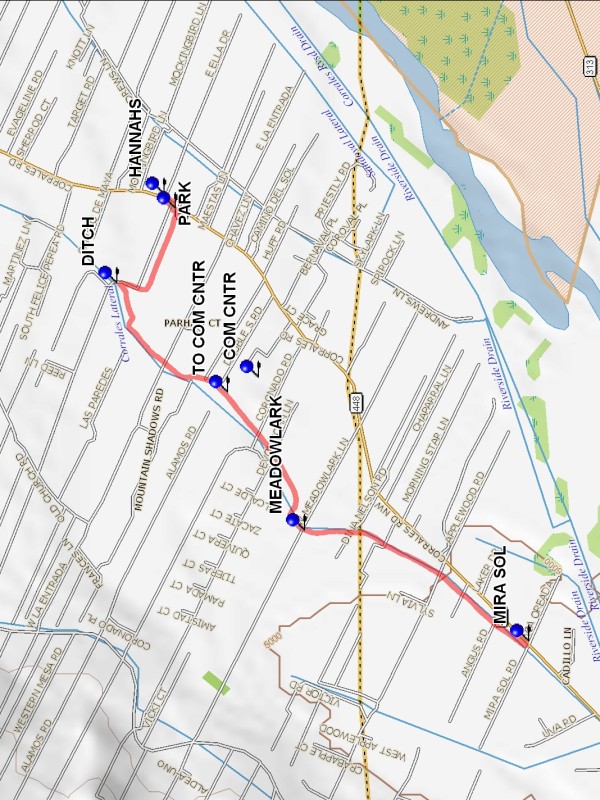
From parking, go west on West Ella to the Corrales Lateral DITCH (0.5 mi), and turn left (south). If you want shade, you’ll find more of it on the east side of the ditch. The Corrales Community Center has porta-potties near the athletic field, so leave the ditch at TO COM CNTR (0.9 mi) and go through the gap in the fence (or the gate) if you need a pit stop. (The center itself opens around noon in the summer for swimming.) Continue going south along the ditch past MEADOWLARK (1.4 mi) (a major cross street) until you reach MIRA SOL (2.1 mi). Turn around, and retrace your steps back to parking. Stop at HANNAHS (4.2 mi) if you want brunch, lunch, or something to drink. In July 2011 they let us order from the children’s menu for an extra $1 charge, still a bargain.
Comments
This is one of the shadiest areas near Albuquerque, wonderful if you hike this in the summer. Enjoy the giant cottonwoods that grace both sides of the ditch. It’s a rural area, so listen for the sounds of roosters, cows, horses, and other barnyard animals. Hannah & Nate’s restaurant is open early for breakfast and lunch, and the Indigo Crow bakery opens at 11:30 on weekdays. If you can’t park at or across from the restaurant, you can park on the side of Corrales Rd at MIRA SOL and reverse the direction of the hike.
WaypointsPARK: N35 13.481, W106 36.892
DITCH: N35 13.617, W106 37.106
TO COM CNTR: N35 13.359, W106 37.419
COM CNTR: N35 13.287, W106 37.375
MEADOWLARK: N35 13.178, W106 37.814
MIRA SOL: N35 12.654, W106 38.131
HANNAHS: N35 13.507, W106 36.850
Hike GPS File Name: CorralesLateralSouthWayTrack_MW.gpx
Hike GPS File: Click link to download hike waytrack file
Text Author: Marilyn Warrant
Map Author: Marilyn Warrant
Waypoints Author: Marilyn Warrant
Track Author: Marilyn Warrant
Maintainer: Not Assigned
Editor: Howard Carr
