Corrales Lateral Loop Short Hike
In Corrales Region
Map File Source: DeLorme
 Hike Key: H10390
Last Updated: 03/04/2021 12:00am
Last Updated By: Marilyn Fixer
Hike Class: B (Moderate)
Hike Distance: 6.8 mi
Minimum Elevation: 5010 ft
Elevation Change: 22 ft
Total Uphill: 22 ft
Total Downhill: 22 ft
Avg. Grade: %
Route Type: CW Loop
On Trail: Yes
Paved or Gravel Roads: Yes
GPS Advised: No
Drive Distance Round Trip: 20 mi
Drive Time One-Way: 0:30
Hiking Seasons: Spring, Fall, and Winter
New Mexico Game Unit: 9
Hike Status: Published
Highlights
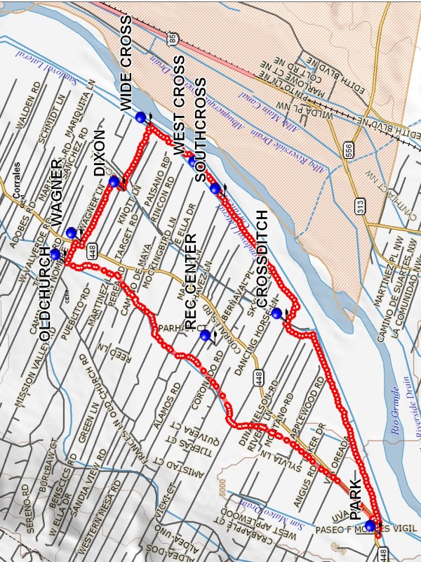
Easy hike along the shady Corrales Lateral drainage ditch then back along the Rio Grande.
CautionsNone.
Trailhead Directions
Go across the Alameda Bridge to the West Side and turn right on SR448, Corrales Road. Go north about 1/2 mile, beyond Cabezon Rd, and park on the east side of the road.
Actual Hike
Go across the road and walk the ditch bank to OLDCHURCH (2.7 mi), then turn right. Cross Corrales Rd to WAGNER (2.9 mi), then take a jog at DIXON (3.4 mi). At WIDE CROSS (3.8 mi), cross over the canal and have lunch near the river. You can walk on the river trail or cross back over and walk along the ditch. There are two more crossing points at WEST CROSS (4.2 mi) and SOUTHCROSS (4.4 mi), then you’re stuck walking on the side you’re on (unless an additional crossing has been built). On the ditch side there is a little detour at CROSSDITCH (5.4 mi), to cross over an acequia.
Comments
The Corrales REC CENTER at 500 Jones Rd has porta potties that we can use if necessary.
WaypointsREC CENTER: N 35 13.273, W 106 37.307
PARK: N 35 12.421, W 106 38.509
OLDCHURCH: N 35 14.048, W 106 36.797
WAGNER: N 35 13.963, W 106 36.661
DIXON: N 35 13.743, W 106 36.339
WIDE CROSS: N 35 13.606, W 106 35.933
WEST CROSS: N 35 13.331, W 106 36.210
SOUTHCROSS: N 35 13.221, W 106 36.380
CROSSDITCH: N 35 12.905, W 106 37.170
Hike GPS File Name: CorralesLateralLoopShortWayTrack_MWMW.gpx
Hike GPS File: Click link to download hike waytrack file
Text Author: Marilyn Warrant
Map Author: Marilyn Warrant
Waypoints Author: Marilyn Warrant
Track Author: Marilyn Warrant
Maintainer: Not Assigned
Editor: Howard Carr