General
Land ownership is important to know for existing hikes and for planning new hikes. BLM maps indicate the type of owner or administrator of a parcel of land. Common land ownership categories are: private, Indian Land or Reservation, National Forest (Admin by USFS), Public land administered by the BLM, National Wildlife Refuge & Management Areas, National Parks/Monuments, and New Mexico State Land. We also identify Wilderness (WA), Wilderness Study Areas (WSA), National Conservation Area (NCA), State Parks, Open Space administered by the City of Albuquerque, and lands along the acequias administered by the Middle Rio Grande Conservancy District.
Boundaries of various land parcels are often available from GIS offices, GIS web pages, or other websites as KMZ files (used by Google Earth). Land ownership files obtained were converted to GPX files that can be imported into consumer topographic mapping software like National Geographic TOPO 4.7 (2010), DeLorme Topo North America 9.0 (2010), and Garmin Topo U.S. 24K Southwest/Basecamp.
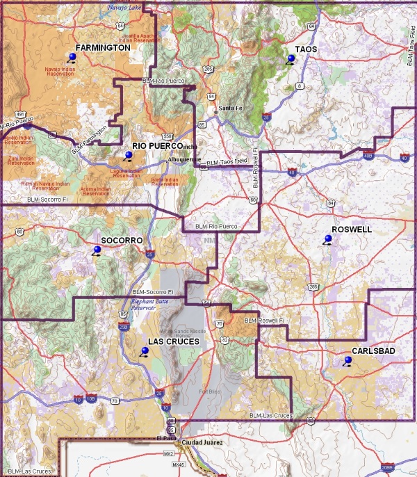
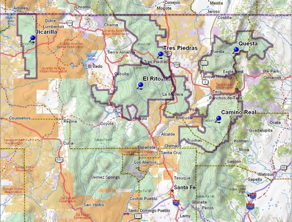
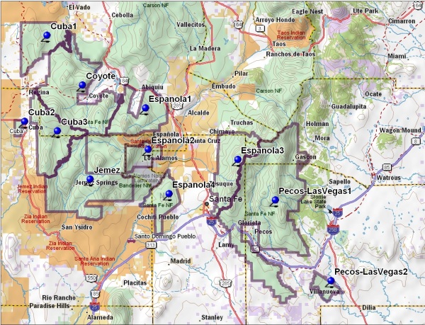
The following maps show the boundaries of the BLM Field Offices and the Ranger Districts of the National Forests:
- BLMDistricts_DeLorme.jpg (242 KB)
- CarsonNationalForestDistricts.jpg (168 KB)
- CibolaNationalForestDistricts.jpg (145 KB)
- SantaFeNationalForestDistricts.jpg (166 KB)
Some GPX files that have been used to determine land ownership for senior hikes are listed in the table below. The file date is the date the KMZ file was converted to a GPX file; the date of the original KMZ file is earlier. The DeLorme Topo North America 9.0 or 10.0 display can be selected to color-code land ownership/administration. However, DeLorme has not updated the data to conform to BLM maps since the software was issued in 2010.
| Land Administrator | Content | File Name | File Size (KB) | Converted File Date |
|---|---|---|---|---|
| All Wilderness Areas in New Mexico | Wilderness_NewMexicoAllWilderness.gpx | 727 | 8/26/2012 | |
| BLM Farmington Field Office | Boundaries | FarmingtonFieldOfficeBLM | 88 | 7/28/2011 |
| BLM Rio Puerco Field Office | Boundaries | RioPuercoFieldOfficeBLM.gpx | 1788 | 7/28/2011 |
| BLM Rio Puerco Field Office | White Mesa Bike Trails | WhiteMesaBikeTrails.gpx | 131 | 10/30/2012 |
| BLM Rio Puerco Field Office | Wilderness Areas | Wilderness_RPFO.gpx | 704 | 2/21/2012 |
| BLM Rio Puerco Field Office | Wilderness Study Areas | WSA_RPFO.gpx | 364 | 8/26/2012 |
| BLM Socorro Field Office | Boundaries | SocorroFieldOfficeBLM.gpx | 99 | 7/28/2011 |
| BLM Socorro Field Office | Wilderness Study Areas | SocorroBLM_SFO_WSA.gpx | 533 | 8/1/2012 |
| City of Albuquerque | Open Space | AlbuquerqueOpenSpace.gpx | 435 | 8/8/2012 |
| NM Continental Divide Trail | CDNST_NM2010_FullTrail.gpx | 54,147 | 6/30/2011 | |
| State of New Mexico | Game Management Units | AllGMUs_NewMexicoUnitsLabels.gpx | 1329 | 7/10/2012 |
| State of New Mexico | New Mexico State Lands | NMStateLands.gpx | 11,556 | 8/3/2012 |
| USFS Carson National Forest | Boundaries | CarsonNatForestRanger_District_ed.gpx | 1033 | 6/27/2011 |
| USFS Carson National Forest | Wilderness Areas | Wilderness_CarsonNatFor.gpx | 340 | 7/25/2011 |
| USFS Cibola National Forest, Sandia Ranger District | Boundaries | CibolaNatForRanger_District_ed.gpx | 643 | 12/11/2011 |
| USFS Cibola National Forest, Sandia Ranger District | Wilderness Areas | CibolaWilderness.gpx | 287 | 2/21/2012 |
| USFS Cibola National Forest, Sandia Ranger District | Sandia Wilderness | SandiaWildernessArea.gpx | 68 | 2/17/2012 |
| USFS Cibola National Forest, Sandia Ranger District | Sandia Wilderness 10-person boundary | SandiaWOS2.gpx | 129 | 2/29/2012 |
| USFS Santa Fe National Forest | Boundaries | SantaFeNatForestRanger_District_ed.gpx | 1696 | 12/11/2011 |
| USFS Santa Fe National Forest | Wilderness Areas | Wilderness_SantaFeNatFor.gpx | 441 | 7/25/2012 |