Sandia Eye Hike
In Sandia Mountain West Region
Map File Source: DeLorme
 Hike Key: H10185
Last Updated: 12/15/2020 12:00am
Last Updated By: Marilyn Warrant
Hike Class: C (Challenging)
Hike Distance: 3.9 mi
Minimum Elevation: 5936 ft
Elevation Change: 1292 ft
Total Uphill: 1292 ft
Total Downhill: 1292 ft
Avg. Grade: 14 %
Route Type: InOut
On Trail: Yes
Paved or Gravel Roads: Yes
GPS Advised: Yes
Drive Distance Round Trip: 20 mi
Drive Time One-Way: 0:15
Hiking Seasons: Spring, Fall, and Winter
New Mexico Game Unit: 8
Hike Status: Published
Highlights
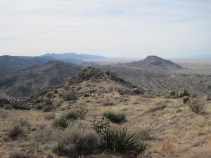
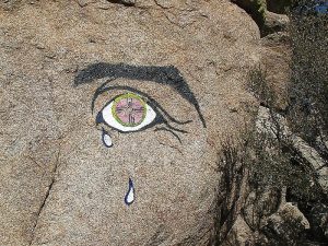
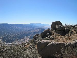
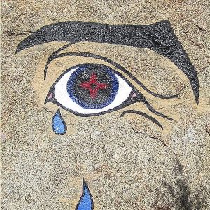
Great views of southern Albuquerque. See the “Eye” for yourself!
CautionsShort but very steep hike. Care must be taken on downhill sections with loose gravel. Trekking poles recommended.
Trailhead Directions
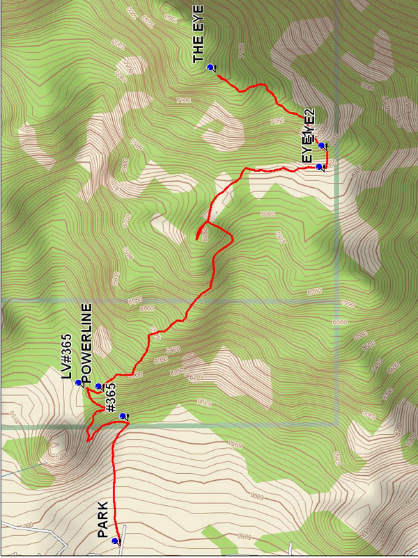
Trail starts at the east end of Copper at PARK (0.0 mi).
Actual Hike
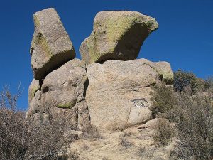
Follow Trail #400 toward mountains, turn left onto Trail #365 (0.3 mi). Trail makes three switchbacks. At the third one, you’ll LV#365 (0.6 mi). Then go south to POWERLINE (0.6 mi), the 4-pole tower under power lines. Turn left (southeast) at power poles and go up steep winding trail on north-facing brow to a saddle with a view to the southwest. Then continue steeply up and then crossing over to the south-facing brow. After the trail sweeps gently to the right and the ridge descends nearly to the trail, watch for a fork. One goes straight ahead, but take the one going up to the left. Cross over the ridge and continue north heading between two peaks. As you hike look to the right (east) and you can see the objective. It looks like a dinner roll (two rocks sitting on top of another) on the skyline across the valley. It is on the right slope of the taller of the two peaks. You will also spot the “Druid”, so named because of the tall wiggly sorcerer hats they wore, a very sharply pointed pinnacle on the right slope of the lower of the two peaks on the skyline. After going between the two peaks and coming out on the northeast side of the eastern peak, go southeast across the valley and go up and behind and far to the right of the Druid to a broken down fence where the trail meets at a tee with another trail. Go left there and continue north up to the top. From here you can see down to I-40 to the southeast as well as Guadalupe and Mosca peaks in the Manzanos to the south. At the top you will see The Eye, ahead and to the right, painted on the base of the “dinner roll.” Lunch at THE EYE (1.9 mi) and return the way you came.
Comments
The “eye” was a 5′ tall painting on the side of a rock. It is a left eye and eyebrow with two tears falling. It may have been repainted. The hike has some great views of southern Albuquerque. Plan on taking many rest breaks as this is a steep one. You will have plenty of time to do so, as it is a short drive and a short hike. It takes only one hour, 20 min. to return to parking area.
The Sandia Ranger District has set a 25-hiker limit for this area.
WaypointsPARK: N 35 04.752, W 106 29.068
#365: N 35 04.737, W 106 28.785
LV#365: N 35 04.819, W 106 28.709
POWERLINE: N 35 04.783, W 106 28.717
EYE1: N 35 04.369, W 106 28.208
EYE2: N 35 04.367, W 106 28.168
THE EYE: N 35 04.574, W 106 27.991
Hike GPS File Name: SandiaEyeWayTrack_MCMC.gpx
Hike GPS File: Click link to download hike waytrack file
Text Author: Roger Holloway
Map Author: Marilyn Warrant
Waypoints Author: Mike Coltrin
Track Author: Mike Coltrin
Maintainer: Not Assigned
Editor: Howard Carr