Nambe Badlands Hike
In Los Alamos Region
Map File Source: NG Topo
 Hike Key: H10307
Last Updated: 12/15/2020 12:00am
Last Updated By: Marilyn Warrant
Hike Class: B (Moderate)
Hike Distance: 5.7 mi
Minimum Elevation: 5990 ft
Elevation Change: 326 ft
Total Uphill: 600 ft
Total Downhill: 600 ft
Avg. Grade: 6 %
Route Type: Figure8
On Trail: No
Paved or Gravel Roads: Yes
GPS Advised: Yes
Drive Distance Round Trip: 160 mi
Drive Time One-Way: 1:45
Hiking Seasons: Spring, Fall, and Winter
New Mexico Game Unit: 44
Hike Status: Published
Highlights
Hike this large area of barren but interesting mud-rock formations and mesas.
CautionsSome edge exposure.
Trailhead Directions
Take I-25 and Bypass 599 north. Exit on US285/84 to Pojoaque. Go another 0.4 mile and turn right on NM 503 toward Nambe. Continue on NM 503 for 4.7 miles to the trailhead. One mile before trailhead, you will pass the Food Distribution Program building on your right. At PARK-GATE there is an unlocked gate below the road level on the west side of the road giving access to BLM land. You will see a brown Bureau of Land Management Property Boundary Public Lands metal marker at the fence line.
Actual Hike
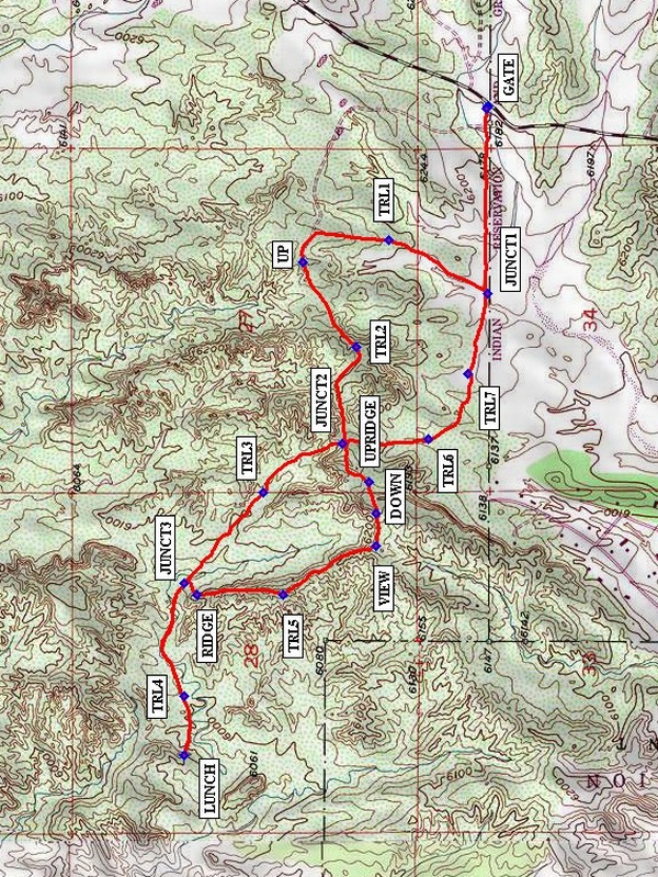
Pass through the gate and walk along the fence line to JUNCT1 (0.5 mi). Take the trail to the right; do not go down into the wash. Enjoy views of the badlands as you walk along at an elevation of about 6200′. You will go uphill to a nice scenic lookout toward the Sangre de Cristo Mountains, featuring the Truchas Peaks in the Pecos Wilderness. Then descend gradually and cross the wash. Begin an ascent at UP (1.2 mi) during which your pulse rate will probably increase, but you will be rewarded by another nice lookout point. Let your heartbeat subside as you take in this lovely setting. See if you can spot your vehicle back at PARK-GATE. Then you will make a moderate descent to JUNCT2 (1.8 mi) which is a 4-way junction marked by a dark gray flat area with a dirt hillock directly in front of you. Turn right (northwest). Look ahead to pillar-like formations resembling a castle which have a beige and tan striping. To your right, see the little hoodoo performing a balancing act. Descend to the wash and walk through it as it winds around in a northwesterly direction. Note various plants and trees that thrive in this sandy environment. Bicycle tracks help to keep you on your desired route as they crosses the wash and do shortcuts across corners. TRL3 will help you stay on track. Look up and around for other landscape shapes. At JUNCT3 (2.4 mi), keep walking straight ahead. Look ahead for two horizontal, layered caps on a mesa, separated by a saddle. When you reach the wash, go right and make your way to the saddle up on the mesa. This is a great LUNCH spot (3 mi).It offers a 360-degree view and you may want to do a little exploring around our lunch area. After lunch, make your way down again to the wash, and walk in reverse direction on same trail you came in on, heading back to JUNCT3 (3.5 mi). Make a right turn here and climb up to RIDGE (3.6 mi). You will experience an exhilarating feeling as you walk along this ridge taking in views on both sides. Note the massive, vertical landform to your left, almost looking like an island in the middle of the desert. Use TRL5 to reassure yourself you are on track. When you reach VIEW (4.1 mi), you may wish to walk to a point where you can get a closer look at this striking landmark. Then, continue on the trail to DOWN (4.2 mi) where you will go straight down the hill. Note that there is a juniper tree where you begin walking downhill. This part of the route has a short, steep descent and bends slightly to the right. Look carefully for a trail that turns sharply to your left toward UPRIDGE. This is a very important turn; do not go further downhill. After making this left turn, you will walk a short distance to UPRIDGE (4.3 mi). Then you will make a short, steep ascent on a narrow ridge before continuing on to JUNCT2 (4.5 mi). Turn right and walk south along the trail. Near TRL6, there is another interesting landform standing as a sentinel. The return route is mostly level, with an occasional dip and rise. You will reach the Nambe Pueblo fence line just before JUNCT1 (5.2 mi). Continue along the fence to PARK-GATE. This is a figure-eight hike; that’s why we cross some waypoints twice. Any extra TRL waypoints are included to help you stay on the track.
Comments
Credit for this hike goes to Joan & Gary Salzman, authors of the book Hiking Adventures in Northern New Mexico.
There is a short off-trail climb to our lunch spot at the saddle; however, it does not involve loose rock. The hiker is able to get good traction on any short ascent or descent. The steep climb at UPRIDGE is on a narrow ridge and might cause a hiker some concern due to dropoffs on either side; however, this is a very brief segment, is not at high elevation, and should not present a problem. This is not a good trail for wet weather as it will be very muddy and slippery.
WaypointsPARK-GATE: N35 55.500, W105 57.750
JUNCT1: N35 55.500, W105 58.333
TRL1: N35 55.750, W105 58.167
UP: N35 55.967, W105 58.233
TRL2: N35 55.833, W105 58.500
JUNCT2: N35 55.867, W105 58.800
TRL3: N35 56.067, W105 58.950
JUNCT3: N35 56.267, W105 59.233
TRL4: N35 56.267, W105 59.583
LUNCH: N35 56.267, W105 59.767
RIDGE: N35 56.233, W105 59.267
TRL5: N35 56.017, W105 59.267
VIEW: N35 55.783, W105 59.117
DOWN: N35 55.783, W105 59.017
UPRIDGE: N35 55.800, W105 58.917
TRL6: N35 55.650, W105 58.783
TRL7: N35 55.550, W105 58.583
Hike GPS File Name: NambeBadlandsWayTrack_DV.gpx
Hike GPS File: Click link to download hike waytrack file
Text Author: Dennis Vick
Map Author: Marilyn Warrant
Waypoints Author: Dennis Vick
Track Author: Dennis Vick
Maintainer: Not Assigned
Editor: Howard Carr