Hay Canyon Loop North From FR144 Hike
In Jemez Mountains Region
Map File Source: NG Topo
 Hike Key: H10521
Last Updated: 12/15/2020 12:00am
Last Updated By: Marilyn Warrant
Hike Class: C (Challenging)
Hike Distance: 6.2 mi
Minimum Elevation: 8455 ft
Elevation Change: 460 ft
Total Uphill: 770 ft
Total Downhill: 770 ft
Avg. Grade: 8 %
Route Type: CCW Loop
On Trail: No
Paved or Gravel Roads: No
GPS Advised: Yes
Drive Distance Round Trip: 150 mi
Drive Time One-Way: 1:45
Hiking Seasons: Spring, Summer, and Fall
New Mexico Game Unit: 6A
Hike Status: Published
Highlights
Pleasant hike down a canyon to the north through a wooded area to a outstanding overlook, then back up pine-lined Hay Canyon.
CautionsNone.
Trailhead Directions
From Albuquerque go North on I-25 to exit 242 (Bernalillo), west on US 550 to San Ysidro. North on SR 4 to La Cueva. Take SR 126 west of La Cueva about four miles to [FR 144]. Take a right, and drive north on the rocky FR 144 about six miles and park at the junction of FR 380 (SR 127) off to the left.
Actual Hike
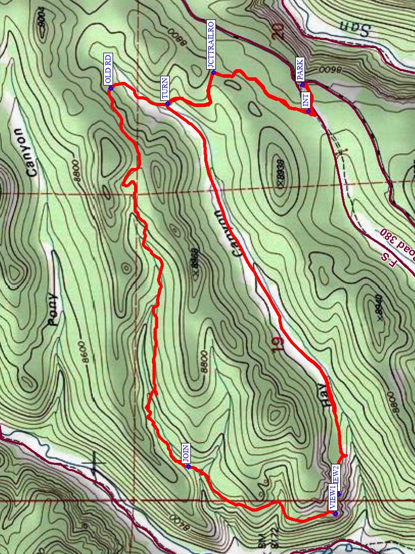
Take FR 380 a short distance, then take a right at the intersection (INT (0.1 mi)) on a trail. After a short climb, a left at a junction with an old road (JCTTRAILRO (0.5 mi)), and a TURN (0.8 mi) to the right, then a turn to the left at OLD RD (1.0 mi), then it’s all downhill (southwest) on an old road that turns into a trail through an unnamed canyon. This portion of the hike is all wooded, watch/listen for turkeys and enjoy the quiet. Take a curve to the left to JOIN (2.6 mi) another trail running generally north/south paralleling the valley to your right and does not go down into the Cebolla River valley. Go south on this trail until you reach several great viewpoints looking down into Cebolla Canyon below. Either VIEW1 (3.3 mi) or VIEW2 (3.4 mi) is a great place to have lunch, explore the caves in the rocks, and look down on the river below. Continue on this trail going straight (northeast) up Hay Canyon. On the way, you’ll go through green meadows where timber has been cut and see massive rock formations typical of the Jemez. At the top of Hay Canyon, TURN (5.4 mi) right onto a 2-track to JCTTRAILRO (5.7 mi), turn right, and retrace your steps back to PARK.
Waypoints
FR 144: N35 53.393, W106 40.022
PARK: N35 56.903, W106 38.701
INT: N35 56.887, W106 38.796
JCTTRAILRO: N35 57.158, W106 38.659
TURN: N35 57.290, W106 38.768
OLD RD: N35 57.453, W106 38.714
JOIN: N35 57.230, W106 40.052
VIEW1: N35 56.809, W106 40.218
VIEW2: N35 56.801, W106 40.150
TURN: N35 57.290, W106 38.768
JCTTRAILRO: N35 57.158, W106 38.659
Hike GPS File Name: HayCanyonLoopNorthFromFR144CCW_DB.gpx
Hike GPS File: Click link to download hike waytrack file
Text Author: Dick Brown
Map Author: Marilyn Warrant
Waypoints Author: Dick Brown
Track Author: Dick Brown
Maintainer: Marilyn Warrant
Editor: Howard Carr