De-na-zin Hike
In Northwest New Mexico Region
Map File Source: DeLorme
 Hike Key: H10342
Last Updated: 03/11/2021 12:00am
Last Updated By: Marilyn Fixer
Hike Class: C (Challenging)
Hike Distance: 4.5 mi
Minimum Elevation: 6180 ft
Elevation Change: 170 ft
Total Uphill: 520 ft
Total Downhill: 520 ft
Avg. Grade: 6 %
Route Type: Loop
On Trail: No
Paved or Gravel Roads: No
GPS Advised: Yes
Hiker Limit (NF/BLM/NP): 8 (BLM Wilderness)
Drive Distance Round Trip: 300 mi
Drive Time One-Way: 2:45
Hiking Seasons:
New Mexico Game Unit: 7
Hike Status: Published
Highlights
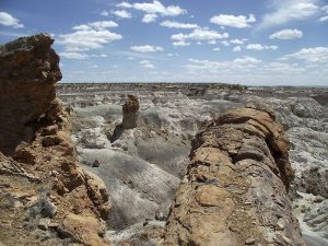
Huge badlands where we hike to a mesa with many formations and a 100-foot-long petrified log.
CautionsThis hike is off trail and some of the hike is over rough and difficult terrain. Hikers without good balance should not participate.
Trailhead Directions
From Albuquerque take I-25 north to Bernalillo. Go west on US 550 through San Ysidro, thru Cuba, Thru Counseler, thru Lybrook. As Heufano Mesa is approached, pass the Indian Medical facility and near the top of the hill there will be a sign “Bisti – De Na Zin (CR7500)”. Set your odometer to zero. Go left and travel the dirt road for 1.7 miles and go right at CR7500 RIGHT. At 7.2 miles go left at CR7500 LEFT.There will be a small De-na-zin sign and a road going right (north) at 11.2 miles. Park in the small parking area.
Actual Hike
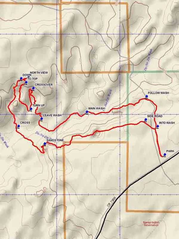
From the parking area go north on the two track which will drop down INTO WASH (0.2 mi). Continue north following the two track to a small wash going west and FOLLOW WASH (0.5 mi) until the MAIN WASH (1.0 mi) is reached. Follow the main De-Na-Zin wash and after 0.4 miles LEAVE WASH (1.4 mi), going north. It will be difficult to execute this portion of the hike to the return to the main wash without the aid of a GPS. Follow the track north as the arroyo narrows to a CROSSOVER (1.8 mi) point, the other side of which you will descend, with a number of large petrified logs along the route to the TURN UP (2.0 mi) point. Follow this side arroyo upward, climbing out to TO TOP (2.2 mi). Go up through the shute to a more level area with many formations. Ascend a small saddle for a good NORTH VIEW (2.3 mi). Then head west to the DOWN (2.4 mi) point. Descend all the way to the main arroyo and go across toward the sandstone cliffs. Continue along the south side of the cliffs untill you find a way upward toward the SANDSTONE formations. Then go east along the edge until the SIDE ROAD (4.1 mi) is reached. This will take you to the two track that you started in on.
Comments
This hike rating has been raised to a C hike. See Cautions.
This is a Federal Wilderness Area with special restrictions, and is administered by the Farmington BLM Office. Group size is limited to 8 people. Break the hikers into groups and hike in opposite directions if there are more than 8 people. See the Bisti/De-Na-Zin website.
WaypointsCR7500: N 36 24.209, W 107 51.158
CR7500 LEFT: N 36 21.143, W 107 57.460
CR7500 RIGHT: N 36 23.461, W 107 52.643
PARK: N 36 18.736, W 108 00.162
INTO WASH: N 36 18.912, W 108 00.220
FOLLOW WASH: N 36 19.098, W 108 00.306
MAIN WASH: N 36 19.002, W 108 00.780
LEAVE WASH: N 36 18.960, W 108 01.140
CROSSOVER: N 36 19.150, W 108 01.205
TURN UP: N 36 19.021, W 108 01.224
TO TOP: N 36 19.186, W 108 01.262
NORTH VIEW: N 36 19.225, W 108 01.241
DOWN: N 36 19.210, W 108 01.302
CROSS: N 36 18.913, W 108 01.322
SANDSTONE: N 36 18.803, W 108 01.114
SIDE ROAD: N 36 18.954, W 108 00.313
Hike GPS File Name: De-na-zinWayTrack_DBDB.gpx
Hike GPS File: Click link to download hike waytrack file
Text Author: Dick Brown
Map Author: Dick Brown
Waypoints Author: Dick Brown
Track Author: Dick Brown
Maintainer: John Cooper
Editor: Howard Carr