Cedro Peak Loop Hike
In Cedro Peak Region
Map File Source: NG Topo
 Hike Key: H10121
Last Updated: 06/29/2021 12:00am
Last Updated By: Marilyn Warrant
Hike Class: C (Challenging)
Hike Distance: 5.7 mi
Minimum Elevation: 7152 ft
Elevation Change: 363 ft
Total Uphill: 770 ft
Total Downhill: 770 ft
Avg. Grade: 6 %
Route Type: CCW Loop
On Trail: Yes
Paved or Gravel Roads: Yes
GPS Advised: No
Drive Distance Round Trip: 45 mi
Drive Time One-Way: 0:45
Hiking Seasons: Spring, Summer, and Fall
New Mexico Game Unit: 14
Hike Status: Published
Highlights
A woodsy walk with occasional meadows, flowers, Western bluebirds and horny toads.
CautionsThere is a significant amount of loose, rocky terrain going up and down hills. There can be fairly large mud puddles to maneuver around.
Trailhead Directions
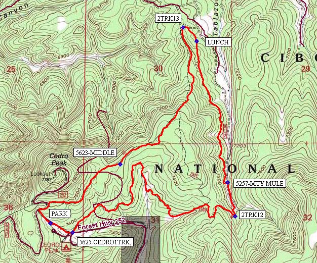
From Albuquerque, take I-40 East. Exit #175 South to Tijeres. From the traffic light in Tijeres, go south on NM 337 (Old Hwy 14) for 5.0 mi to Juan Tomas Road, where you will turn left. At 5.7 mi, turn left (northeast) on Forest Road 252. Proceed 1.1 mi to PARK (0.0 mi) just past the Cedro Group Cmpgrnd.
Actual Hike
From PARK (0.0 mi) walk back down the road to reach 5625-CEDRO1TRK (0.2 mi). Continue for two miles to the bottom of the canyon and turn left (north) onto 2TRK12 (2.1 mi).
In 0.2 mile you will reach 5257-MTY MULE (2.3 mi) on your left (by first taking the 5626 Rattlesnake trail for a few meters). Continue on the Mighty Mule trail up to LUNCH (3.5 mi) where you’ll find a couple of logs to sit on.
After lunch trek on to 2TRK13 (3.6 mi) where you’ll turn left (south). This 2-track is plenty wide, but quite rocky and steadily upward.
Keep looking to your left for 5623-MIDDLE (5.2 mi) trail and continue on it to PARK. The Middle trail may utilize parts of county roads 252 and 542 over the last half mile to reach the parking lot.
Comments
The Cedro Peak Loop hike trails are shown close to the middle of the Manzanita Mountains Trail System map.
Hike data were determined using a Garmin GPSMap 62 and Garmin BaseCamp’s DEM for TOPO US 24K Southwest.
WaypointsPARK: N35 02.894, W106 21.160
5625-CEDRO1TRK: N35 02.842, W106 21.003
2TRK12: N35 02.936, W106 19.858
5257-MTY MULE: N35 03.132, W106 19.910
LUNCH: N35 03.954, W106 20.129
2TRK13: N35 04.032, W106 20.226
5623-MIDDLE: N35 03.237, W106 20.668
Hike GPS File Name: CedroPkLp_BG.gpx
Hike GPS File: Click link to download hike waytrack file
Text Author: Bill Gloyd
Map Author: Bill Gloyd
Waypoints Author: Bill Gloyd
Track Author: Bill Gloyd
Maintainer: Bill Gloyd
Editor: Marilyn Warrant