Canoncito De Las Cabras Hike
In Socorro Region
Map File Source: DeLorme
 Hike Key: H10073
Last Updated: 12/15/2020 12:00am
Last Updated By: Marilyn Warrant
Hike Class: B (Moderate)
Hike Distance: 5.6 mi
Minimum Elevation: 5165 ft
Elevation Change: 410 ft
Total Uphill: 420 ft
Total Downhill: 420 ft
Avg. Grade: 5 %
Route Type: InOut
On Trail:
Paved or Gravel Roads:
GPS Advised:
Drive Distance Round Trip: 140 mi
Drive Time One-Way: 1:30
Hiking Seasons: Spring, Fall, and Winter
New Mexico Game Unit: 13
Hike Status: Inactive
Highlights
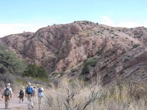
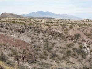
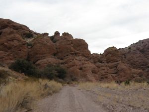
An interesting slot canyon with good views of the San Lorenzo Canyon area, Polvadera Mountain to the south, and the Sevilleta National Wildlife Refuge to the north.
CautionsIntrudes on private land, unavoidable.
Trailhead Directions
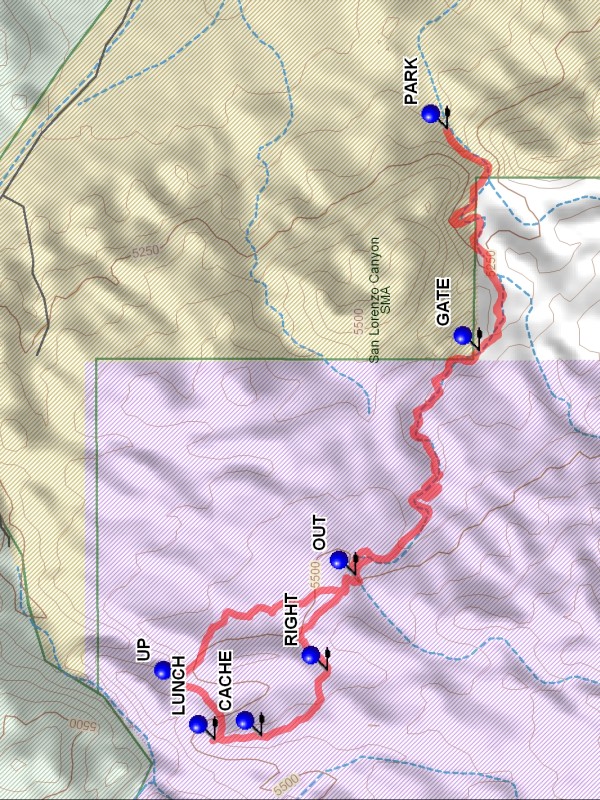
From Albuquerque take I-25 south to the San Acacia exit. Proceed to the East side of I-25 and take the access road South to the road that goes under I-25 and turn right. After going under I-25, at the bend in the road go straight onto the dirt road. Do not turn at the San Lorenzo Canyon right turn sign. Go to the PARK (0.0 mi) waypoint, about 4 miles and just before entering a notch.
Actual Hike
Walk up Canoncito de las Cabras to the GATE (0.8 mi). Go through the gate and continue to the OUT (1.9 mi) waypoint, where a two track will take you out of the canyon on the right side. Follow the road north to RIGHT (2.3 mi) where you leave the road and continue north up to the ridge. Once on the ridge continue east to LUNCH (2.7 mi). After enjoying the view drop down off of the ridge to the north east to view an interesting side canyon. At UP (2.9 mi) go south east onto a plain and continue south to rejoin the road you came up on. From this point retrace your steps to parking.
Comments
INACTIVE HIKE – Notch area is private land and is now posted
This is a hike through an interesting slot canyon to the south of San Lorenzo Canyon. At the end point there is a good view of the San Lorenzo Canyon area, Polvadera Mountain to the south, and the Sevilleta National Wildlife Refuge to the north. Do not go after wet weather as the road into the canyon is sandy.
WaypointsSAN LORENZO RIGHT: N34 13.602, W106 57.299
PARK: N34 13.491, W106 58.858
GATE: N34 13.416, W106 59.484
OUT: N34 13.706, W107 00.120
RIGHT: N34 13.771, W107 00.388
CACHE: N34 13.925, W107 00.572
LUNCH: N34 14.035, W107 00.584
UP: N34 14.116, W107 00.432
Hike GPS File Name: CanoncitoDeLasCabrasWayTrack_DBDB.gpx
Hike GPS File: Click link to download hike waytrack file
Text Author: Dick Brown
Map Author: Marilyn Warrant
Waypoints Author: Dick Brown
Track Author: Dick Brown
Maintainer: Marilyn Warrant
Editor: Howard Carr