Bisti Hike
In Northwest New Mexico Region
Map File Source: DeLorme
 Hike Key: H10341
Last Updated: 12/05/2023 8:27pm
Last Updated By: Marilyn Fixer
Hike Class: C (Challenging)
Hike Distance: 7.2 mi
Minimum Elevation: 5760 ft
Elevation Change: 120 ft
Total Uphill: 305 ft
Total Downhill: 305 ft
Avg. Grade: 2 %
Route Type: Loop
On Trail: No
Paved or Gravel Roads: No
GPS Advised: Yes
Hiker Limit (NF/BLM/NP): 8 (BLM Wilderness)
Drive Distance Round Trip: 340 mi
Drive Time One-Way: 3:15
Hiking Seasons: Spring and Fall
New Mexico Game Unit: 7
Hike Status: Published
Highlights
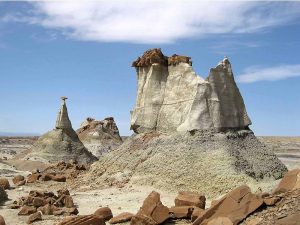
Premier mesa/badlands hike. A photographer’s dream.
CautionsLittle shade. Some difficult terrain and steep pitches. Trekking poles recommended.
Trailhead Directions
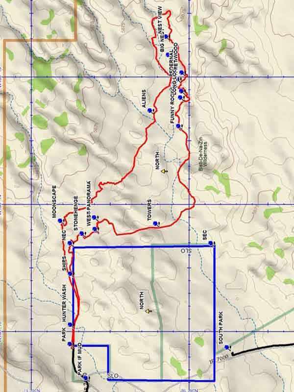
From Albuquerque take I-25 north to Bernalillo. Go west on US 550 through San Ysidro, thru Cuba, Thru Counseler, thru Lybrook. As Heufano Mesa is approached, pass the Indian Medical facility and near the top of the hill there will be a sign “Bisti – De Na Zin”. Go left and travel dirt CR 7500 for 25 miles to a SR 371 and go north. Go 8 miles on SR 371 to IR 7295 and turn right. Go 2 miles to a T and turn left. Go 1.2 miles to SOUTH PARK and park on the right in the small parking area. Or, go 12 miles on SR 371 TO NORTH PARK. At about 11.5 miles, coming out of a vast wash, you will see a gas pumping station on your right followed soon by a power substation. Very shortly after the substation, turn right onto CR7293, a narrow gravel road. Go 0.7 miles and turn RIGHT on a gravel road which goes south, descending into a wash and bending around to the left where the gravel ends where you PARK IF MUD. Otherwise continue to a fence and go south along the fence to PARK.
Actual Hike
Go under the fence and go east along the fence to HUNTER WASH (0.1 mi). Cross the wash and head toward the left side of the formation ahead. Beyond the broad flat ahead you will see a multifaceted ridge. Head toward the SHIPS (0.5 mi) at the left end of the panorama and ascend up along the right side of the formations until the top is reached. There will be good views to the north and also the east with it’s many formations. Turn southward and go along the edge of the arroyo blocking your way to the east and visit STONEHENGE (1.0 mi). Then continue south and up onto a ridge for a WEST PANORAMA (1.1 mi) view of the forbidden SLO Land. Then turn back east and find your way to MODERN ART (1.2 mi). From this point drop down into an arroyo which will go southward to TOWERS (1.8 mi). Cross a broad east/west running wash to the south side and turn east. Go along the south edge of the wash to FUNNY ROCKS (2.8 mi). Continue on to LONG LOG (3.0 mi), then SHORT LOG (3.1 mi), where you will be in an amazing profusion of formations. Then head on towards the PEDERNAL (3.3 mi) and turn into an arroyo for more petrified wood at PET WOOD (3.3 mi). Continue east in the arroyo, curling around and ascending to NEST VIEW (3.7 mi) for a great view of the BIG NEST. Then continue east, then north, dropping down into a major arroyo. Go west in this arroyo, now staying on the north side of the arroyo to ALIENS (4.9 mi). This section of the hike is difficult to describe and requires the use of a GPS. The track will go northeast to MOONSCAPE (6.3 mi) with many interesting formations along the way. At this point drop into the arroyo below. This arroyo flows into Hunter Wash. Go west along the formations on the left to SHIPS, then return the way you came to parking.
Comments
This is a Federal Wilderness Area with special restrictions, and is administered by the Farmington BLM Office. Group size is limited to 8 people. Break the hikers into groups and hike in opposite directions if there are more than 8 people. See the Bisti/De-Na-Zin website.
WaypointsBIG NEST: N36 16.111, W108 12.861
NEC: N36 16.734, W108 14.340
PARK IF MUD: N36 16.633, W108 15.399
SEC: N36 15.840, W108 14.340
SOUTH PARK: N36 15.738, W108 15.159
TO NORTH PARK: N36 17.298, W108 16.302
TO SOUTH PARK: N36 13.911, W108 16.294
TURN RIGHT: N36 17.405, W108 15.517
PARK: N36 16.733, W108 15.133
HUNTER WASH: N36 16.732, W108 14.980
SHIPS: N36 16.732, W108 14.580
STONEHENGE: N36 16.658, W108 14.264
WEST PANORAMA: N36 16.575, W108 14.228
MODERN ART: N36 16.578, W108 14.138
TOWERS: N36 16.192, W108 14.186
FUNNY ROCKS: N36 16.045, W108 13.419
LONG LOG: N36 16.033, W108 13.196
SHORT LOG: N36 16.027, W108 13.147
PEDERNAL: N36 16.054, W108 13.052
PET WOOD: N36 16.025, W108 13.000
NEST VIEW: N36 16.124, W108 12.717
ALIENS: N36 16.226, W108 13.298
MOONSCAPE: N36 16.795, W108 14.164
Hike GPS File Name: BistiWayTrack_DBDB.gpx
Hike GPS File: Click link to download hike waytrack file
Text Author: Dick Brown
Map Author: Dick Brown
Waypoints Author: Dick Brown
Track Author: Dick Brown
Maintainer: Carl Gervais
Editor: Randy Simons