Arroyo Tinajas – Gonzales Mine Hike
In Socorro Region
Map File Source: DeLorme
 Hike Key: H10246
Last Updated: 12/15/2020 12:00am
Last Updated By: Marilyn Warrant
Hike Class:
Hike Distance: 5.9 mi
Minimum Elevation: 5000 ft
Elevation Change: 280 ft
Total Uphill: 480 ft
Total Downhill: 480 ft
Avg. Grade: 5 %
Route Type: CW Loop
On Trail: No
Paved or Gravel Roads: No
GPS Advised: Yes
Drive Distance Round Trip: 180 mi
Drive Time One-Way: 1:45
Hiking Seasons: Spring, Fall, and Winter
New Mexico Game Unit: 18
Hike Status: In Process
Access Description: Quebradas Access
Attractions: Arroyos, Badlands, Rock Formations, and Views
Highlights
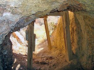
Arroyo, interesting terrain, abandoned mines where bats may be spotted.
CautionsSome difficult terrain and steep pitches. Trekking poles recommended.
Trailhead Directions
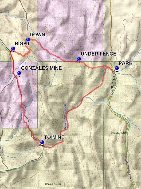
From Albuquerque take I-25 south to the Lemitar exit. Go east for 0.5 mile on SR 408 E. Turn right onto SR-408 and go 3 miles to Escondido (Hidden) Lake. Turn left and go 1.6 miles (the road curves to the right after crossing the Rio Grande) to a sign “Quebradas Back Country Scenic Byway.” Turn left and go 8 mi. to PARK (0.0 mi). Park on the right before crossing the arroyo.
Actual Hike
From Parking go west down the Arroyo Tinajas which shortly bears southwest. The arroyo is largely smooth, but has some interesting rocky and “paved” sections as it continues for about 2 miles. At this point a blockage is reached with smooth surfaces and drop-offs. Explore the arroyo at this point, but do not attempt to reach the very bottom of the blockage. It can be a long way back out. Then head north at the TO MINE (2.0 mi). In the distance there will be a mine opening on the south facing wall. This is impressive, but not the Gonzales mine. Find a road which will go uphill at a steep pitch to the west of the opening. It will be 1.4 miles from the arroyo to the GONZALES MINE (3.3 mi). There are several mine openings and artifacts in the area. This is a barite mine, with some traces of fluorite. If the mine entrance to the right of the road is entered, it is possible to see fluorite with its pale green-blue color while out of the bright sunlight. Use care, there are vertical shafts in the area and the area is unprotected.
After the mine visit continue north for 0.4 miles to a trail on the RIGHT (3.7 mi). Go east as the trail becomes clearer, winding back and forth to the ridge which is east of the mine. Once on the ridge do not continue on the trail, which ends on the road, but six miles from parking. Going along the steep east side of the ridge drop DOWN (4.3 mi), heading for the notch below. Once through the notch turn southeast. Eventually an east-west fence is encountered. Go along the north side of the fence to UNDER FENCE (5.3 mi).Go to the south side of the fence. It is possible to follow the fence to the road, but bearing to the south is easier.
Comments
This hike is in the Presilla WSA, wilderness restrictions apply. The climb out of Arroyo Tinajas going north is steep, as is the DOWN point. The hike can also be done as an in-out hike by returning by way of the Arroyo. This will add a mile to the hike distance. Rating raised to C due to terrain Difficulty and steep pitches. The purple color on the map denotes land administered by the state land office.
WaypointsPARK: N34 05.019, W106 46.797
TO MINE: N34 04.044, W106 47.991
GONZALES MINE: N34 04.956, W106 48.360
RIGHT: N34 05.280, W106 48.458
DOWN: N34 05.397, W106 48.217
UNDER FENCE: N34 05.143, W106 47.403
Hike GPS File: Click link to download hike waytrack file
Text Author: Dick Brown
Map Author: Marilyn Warrant
Waypoints Author: Dick Brown
Track Author: Dick Brown
Maintainer: John Cooper
Editor: Marilyn Warrant