Apache Ridge – Arroyo Hondo Hike
In Sangre De Cristos Region
Map File Source: NG Topo
 Hike Key: H10144
Last Updated: 12/15/2020 12:00am
Last Updated By: Marilyn Warrant
Hike Class: C (Challenging)
Hike Distance: 4.7 mi
Minimum Elevation: 8000 ft
Elevation Change: 633 ft
Total Uphill: 850 ft
Total Downhill: 850 ft
Avg. Grade: 8 %
Route Type: CCW Loop
On Trail:
Paved or Gravel Roads:
GPS Advised:
Drive Distance Round Trip: 140 mi
Drive Time One-Way: 1:30
Hiking Seasons: Spring, Summer, and Fall
New Mexico Game Unit: 44
Hike Status: Inactive
Highlights
A lovely hike through shady woods, pretty glades, and great views.
CautionsSome strenuous uphill sections; hiking poles recommended.
Trailhead Directions
At Santa Fe exit 284 go left to intersection of Rodeo Road and Old Pecos Trail. Turn right and follow Old Las Vegas Hwy going southeast. Go to just before milepost three and look for a brown sign, Camp Stoney (County Road 67C). TURN LEFT here. In about a mile TURN RIGHT onto County Rd 67 and follow it to a “Y” where you will go left (on County Road 67A) and down the hill through town of Canada de Los Alamos (blue-roofed church.) Pavement ends and gravel begins. Road curves to left and goes uphill (north); in 0.7 mi. where road splits go left again (instead of straight ahead.). Watch for sign “Treehouse Road”, then another sign “Forest Road 79.” Turn left onto FR 79 and follow it 2.7 mi. to Baldy Trailhead and PARK (0.0 mi).
Actual Hike
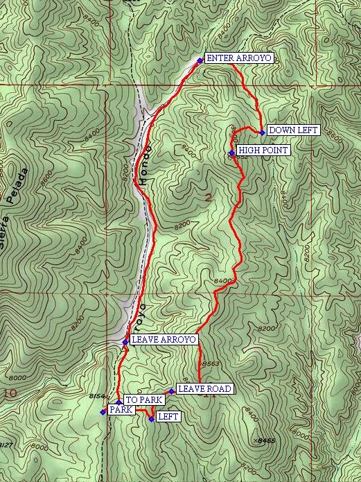
From the Baldy Trailhead parking, walk east on the road that intersects with FR 79 and soon you will come upon a map or sign that shows the trail to Glorieta Baldy (TR 175) with a shorter loop back by using Apache Tr. 176. Continue LEFT (0.3 mi) on the road for 0.2 miles to a path leading uphill on the left, marked by a cairn. LEAVE ROAD (0.5 mi) here or enjoy a very long hike to Glorieta Baldy. The sometime faint two track follows a north-south ridge with many ups and downs to the HIGH POINT (2.0 mi) on the hike. The route then drops down the east face of the ridge and turns north, curling around to the west. At the bottom go DOWN LEFT (2.2 mi) along a narrow canyon to ENTER ARROYO (2.7 mi). This is Arroyo Hondo. Go left down the arroyo for 1.6 miles and LEAVE ARROYO (4.3 mi) bear left out of the arroyo. At the top go right TO PARK (4.6 mi).
Comments
Pleasant hike on a Ponderosa pine needle-covered forest floor. On this hike, you may find some Earth Stars. If you don’t know what they are, an internet search will yield “Earthstars belong to a group of fungi called Gasteromycetes, or “stomach fungi”. Their fruiting bodies are a stomach-shaped sac filled with dry spores”.
This hike is marked “inactive” since the Arroyo Hondo part is on private land.
WaypointsTURN LEFT: N35 35.962, W105 54.450
TURN RIGHT: N35 36.595, W105 53.919
PARK: N35 37.795, W105 51.529
LEFT: N35 37.766, W105 51.277
LEAVE ROAD: N35 37.882, W105 51.174
HIGH POINT: N35 38.890, W105 50.860
DOWN LEFT: N35 38.977, W105 50.704
ENTER ARROYO: N35 39.281, W105 51.026
LEAVE ARROYO: N35 38.091, W105 51.414
TO PARK: N35 37.835, W105 51.445
Hike GPS File Name: ApacheRidge-ArroyoHondoWayTrack_DBDB.gpx
Hike GPS File: Click link to download hike waytrack file
Additional File 1 Link Click link to download an additional file.
Text Author: Roger Holloway
Map Author: Marilyn Warrant
Waypoints Author: Dick Brown
Track Author: Dick Brown
Maintainer: Marilyn Warrant
Editor: Marilyn Warrant