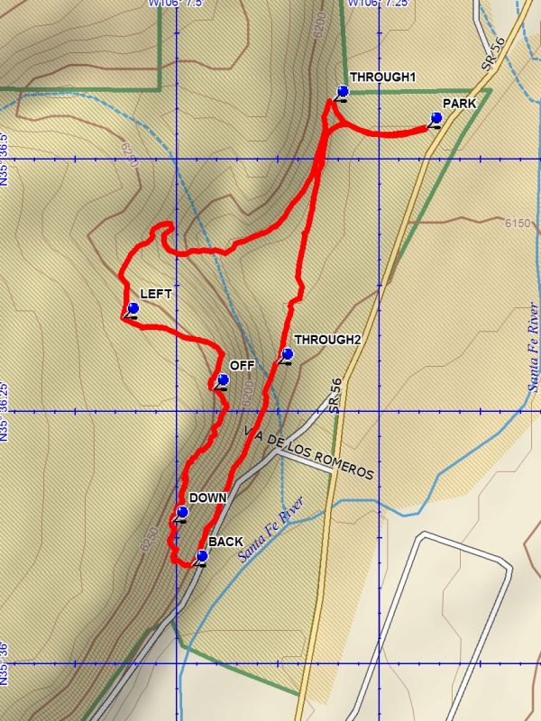
Cieneguilla Petroglyphs Loop Hike
In Santa Fe Region
Map File Source: DeLorme
 Hike Key: H10531
Last Updated: 12/15/2020 12:00am
Last Updated By: Marilyn Warrant
Hike Class: B (Moderate)
Hike Distance: 1.7 mi
Minimum Elevation: 6145 ft
Elevation Change: 120 ft
Total Uphill: 250 ft
Total Downhill: 250 ft
Avg. Grade: 5 %
Route Type: CCW Loop
On Trail: No
Paved or Gravel Roads: Yes
GPS Advised: No
Drive Distance Round Trip: 100 mi
Drive Time One-Way: 1:00
Hiking Seasons: Spring, Summer, Fall, and Winter
New Mexico Game Unit: 6C
Hike Status: Published
Highlights
Outstanding extensive collection of petroglyphs.
CautionsDo not go on this hike if you have balance problems, as the area where the petroglyphs are located is steep and rocky.
Trailhead Directions
I-25 north to the La Cienega Exit 271. Go northwest (left) about 1 mile into the village of La Cienega on Entrada La Cienega (NM587). After passing through the village, turn right onto Los Pinos Rd (CR54). Follow Los Pinos Rd (CR54) for 1.2 miles to Las Golondrinas. At this point drive straight onto Paseo Real (CR56). Follow Paseo Real (CR56) for 2.7 miles to the trailhead parking (PARK) on the left.
Actual Hike
Go west from parking toward a fence and bear right to THROUGH1. Go through the fence and turn left and follow the trail. This trail will take an interesting traverse up the north end of the low mesa and onto open terrain. The trail will intersect a two track at LEFT (0.6 mi). Go left on this two track which will turn right near the edge of the mesa to the point OFF (0.8 mi). Go down at this point and join a trail which runs along the side of the mesa, going south. Along this segment you will find a multitude of petroglyphs until you reach DOWN (1.0 mi). Work your way down in a traverse to the bottom and turn BACK (1.1 mi) north. Go north to THROUGH2 (1.3 mi) and go back through the fence. Follow the path back to parking.
Waypoints
PARK: N35 36.532, W106 07.193
THROUGH1: N35 36.557, W106 07.308
LEFT: N35 36.343, W106 07.566
OFF: N35 36.272, W106 07.456
DOWN: N35 36.140, W106 07.506
BACK: N35 36.097, W106 07.482
THROUGH2: N35 36.297, W106 07.377
Hike GPS File Name: CieneguillaPetroglyphsLoopWayTrack_DBDB.gpx
Hike GPS File: Click link to download hike waytrack file
Text Author: Dick Brown
Map Author: Dick Brown
Waypoints Author: Dick Brown
Track Author: Dick Brown
Maintainer: John Cooper
Editor: Dawn McIntyre