Carlito Springs Open Space Hike
In Sandia Mountain South Region
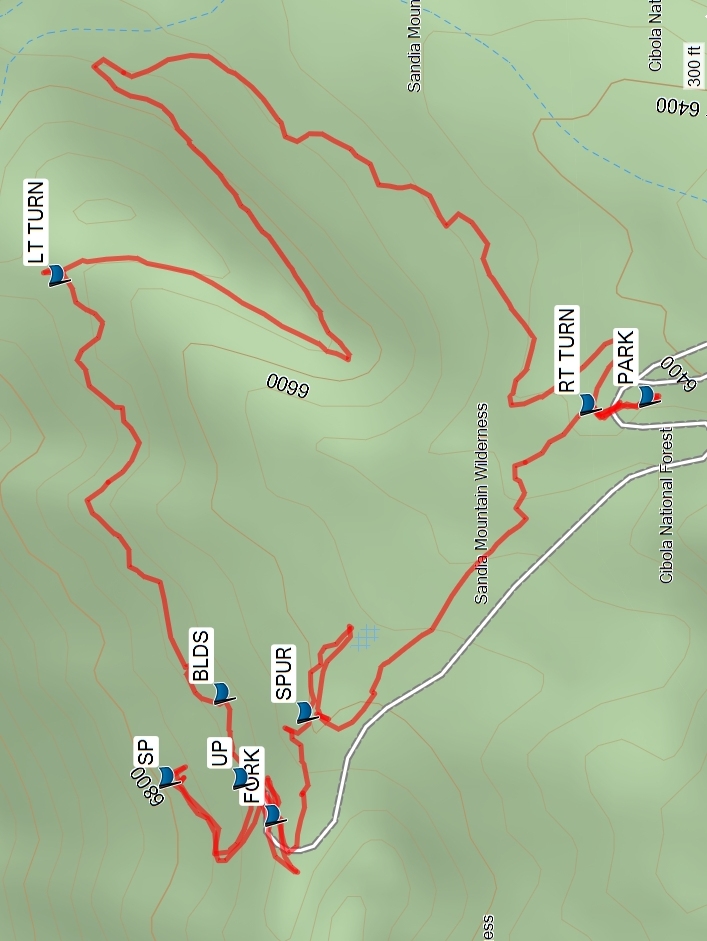
Map File Source: Garmin BaseCamp
 Hike Key: H10545
Last Updated: 02/24/2025 5:34pm
Last Updated By: Marilyn Fixer
Hike Class: B (Moderate)
Hike Distance: 2.6 mi
Minimum Elevation: 6405 ft
Elevation Change: 365 ft
Total Uphill: 420 ft
Total Downhill: 420 ft
Avg. Grade: 9 %
Route Type: Messy
On Trail: Yes
Paved or Gravel Roads: Yes
GPS Advised: No
Drive Distance Round Trip: 30 mi
Drive Time One-Way: 0:15
Hiking Seasons: Spring, Summer, and Fall
New Mexico Game Unit: 8
Hike Status: Published
Highlights
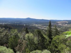
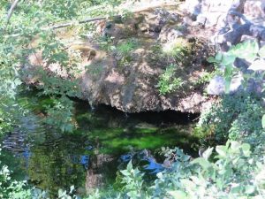
It is worth the short trip to see the lovely rock-lined pools and historic structures. The trail itself is well laid-out with interesting terrain, enough hills for exercise, and excellent views.
CautionsNone.
Trailhead Directions
I-40 East to Tijeras exit then right at light to Carlito Springs Rd.(across from Roosevelt Middle School), go under freeway and turn right. Make the second left turn (at county sign), proceed up road to parking area (be careful of this narrow road).
Actual Hike
From PARK (0.0 mi), proceed to RT TURN (0.1 mi) and follow trail to LT TURN (1.05 mi). Proceed on the main trail to BLDS (1.4 mi). Proceed up hill at UP (1.5 mi) to SP (1.8 mi) to see water source and great panoramic views. Next proceed back down hill to FORK (1.9 mi) and take the road on the left side of fork to SPUR (2.1 mi). Continue down road to see fruit trees at orchard (some of which have metal identifying tags). At the enormously large but dead tree, turn around and proceed back up dirt road to SPUR and go left (south) over metal foot bridge and follow trail back to parking area.
Comments
The orchard area with the fruit trees will be closed every fall due to bears feeding there. Watch out for poison ivy along the creek after the waypoint SPUR. We saw many deer and other wildlife tracks on the trail.
WaypointsPARK: N35 05.065, W106 23.729
RT TURN: N35 05.094, W106 23.734
LT TURN: N35 05.357, W106 23.658
BLDS: N35 05.273, W106 23.914
UP: N35 05.264, W106 23.966
SP: N35 05.300, W106 23.965
FORK: N35 05.248, W106 23.989
SPUR: N35 05.233, W106 23.925
Hike GPS File Name: CarlitoSpringsWayTrackRev_FE.gpx
Hike GPS File: Click link to download hike waytrack file
Text Author: Frank Ernst
Map Author: Marilyn Warrant
Waypoints Author: Frank Ernst
Track Author: Frank Ernst
Maintainer: Not Assigned
Editor: Howard Carr