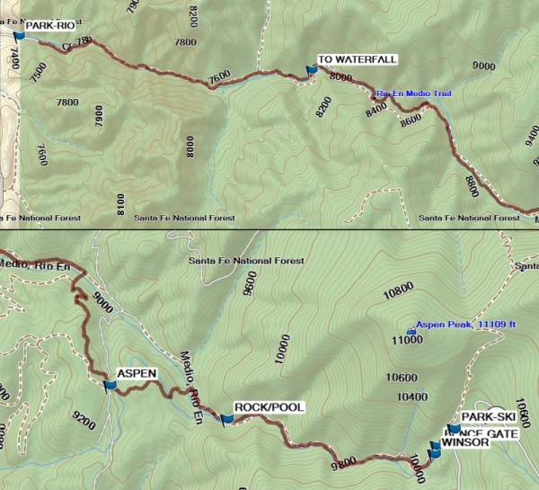
Rio en Medio One-Way from East TH Hike
In Sangre De Cristos Region
Map File Source: Garmin BaseCamp
 Hike Key: H10686
Last Updated: 02/17/2021 12:00am
Last Updated By: Marilyn Fixer
Hike Class: D (Difficult)
Hike Distance: 6.9 mi
Minimum Elevation: 7225 ft
Elevation Change: 2905 ft
Total Uphill: 240 ft
Total Downhill: 3180 ft
Avg. Grade: 12 %
Route Type: Oneway
On Trail: Yes
Paved or Gravel Roads: Yes
GPS Advised: Yes
Drive Distance Round Trip: 190 mi
Drive Time One-Way: 1:45
Hiking Seasons: Summer and Fall
New Mexico Game Unit: 44
Hike Status: Inactive
Highlights
A chance to do the full Rio en Medio trail. A waterfall that you can go behind.
CautionsFairly steep downhill all the way, so don’t go on this one if you have bad knees. Wear sturdy boots. Bring hiking poles for the stream crossings and water shoes for the waterfall.
Trailhead Directions
To PARK-SKI, from Albuquerque, take I-25 to the St. Francis exit in Santa Fe. Go just past Paseo de Peralta, and turn right onto Alameda. Continue along the Santa Fe River and turn left on Gonzales. At the intersection with the road to the Ski Area, turn right. Continue on to the Winsor Trail parking lot near the Santa Fe Ski Area and PARK. Leave the hikers here. Return to Santa Fe using Hyde Parkway.
To PARK-RIO, from Santa Fe, get onto US 84/285, go north to Exit 172 and exit to the right onto Hwy 73. Go for 0.4 mi and turn left onto Hwy 592. Stay on this road for about 6 mi, going through the village of Rio en Medio. (There is a sharp left turn after 3 miles on this road.) In the village continue past the church to PARK (0.0 mi) or find another parking location if the lot is full.
Actual Hike
From the trail starting at the pit toilets, go a short distance up the trail then turn left at the Rio en Medio sign. Continue through the FENCE GATE (0.1 mi). Keep right at the intersection with the Winsor Trail (0.2 mi). Take a short break at the ROCK/POOL (1.4 mi). At the intersection with the Aspen Ranch road (2.2 mi), keep to your right joining the Borrego Trail going north. Return to the Rio en Medio by taking a 90 deg turn to go north-east until reaching the way TO WATERFALL (5.2 mi). Find a trail to the right, change to your water shoes, and wade behind the waterfall. After that, continue down the trail to PARK-RIO (6.9 mi). (If desired, you can miss most of the stream crossings by keeping to the right-hand (north) side of the stream.)
Comments
The full hike track was obtained from Santa Fe County Trails, which agreed with tracks I recorded at the two end sections of the hike.
Affected by the 2020 Medio fire, so set Inactive.
WaypointsPARK-SKI: N35 47.728, W105 48.263
FENCE GATE: N35 47.660, W105 48.352
WINSOR: N35 47.626, W105 48.363
ROCK/POOL: N35 47.767, W105 49.419
ASPEN RANCH: N35 47.905, W105 50.014
TO WATERFALL: N35 49.107, W105 51.900
PARK-RIO: N35 49.264, W105 53.608
Hike GPS File Name: RioEnMedioAll500_MW.gpx
Hike GPS File: Click link to download hike waytrack file
Text Author: Marilyn Warrant
Map Author: Marilyn Warrant
Waypoints Author: Marilyn Warrant
Track Author: Marilyn Warrant
Maintainer: Marilyn Warrant
Editor: Marilyn Warrant