North Mystery Trail to Lagunita Seca Hike
In Sandia Mountain East Region
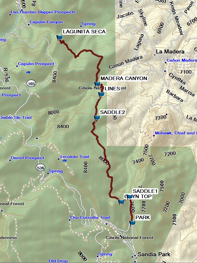
Map File Source: Garmin BaseCamp
 Hike Key: H10676
Last Updated: 03/10/2021 12:00am
Last Updated By: Marilyn Fixer
Hike Class: D (Difficult)
Hike Distance: 9.9 mi
Minimum Elevation: 7360 ft
Elevation Change: 755 ft
Total Uphill: 2190 ft
Total Downhill: 2190 ft
Avg. Grade: 10 %
Route Type: InOut
On Trail: Yes
Paved or Gravel Roads: Yes
GPS Advised: No
Drive Distance Round Trip: 0 mi
Drive Time One-Way:
Hiking Seasons: Spring, Summer, and Fall
New Mexico Game Unit: 8
Hike Status: In Process
Highlights
This is a beautiful, little-used trail running through healthy forest land and ending at a meadow just below Palomas Peak. There are three medallions between the start of the trail and a short distance into the meadow.
CautionsNone.
Trailhead Directions
Take I-40 east from Albuquerque, then go north on NM 14 for six miles, and take the turnoff to the Crest Highway (NM 536). Drive 2.4 miles along the Crest Highway and park on the left side of the road at a long pullout 0.4 miles past the turnoff to the Doc Long Picnic Ground, just before a sharp turn in the road. The trail begins on the east side of the Crest Highway, just after a guardrail.
Actual Hike
From the trailhead, the trail heads up Barro Canyon north of the Crest Highway from the hairpin trail. The first portion of the trail keeps to the eastern slope just above the canyon bottom. After 0.4 miles the trail comes to a distinct saddle point. North Mystery Trail goes west, up the hill from the saddle point. Look for diamond blazes on the trees. Some of the blazes are etched with “Faulty Trail.” The trail climbs steeply uphill from the saddle point to the top of a canyon. The trail continues north on relatively flat terrain for almost two miles through beautiful and isolated country. There are nice views of Tecolote Peak to the west through this stretch. The trail passes through a noticeable saddle point at 2.3 miles into the hike at elevation 7,960, then begins a steep dip into Madera Canyon. The trail then passes under a set of power lines at 2.7 miles. From here there are impressive views of Capulin Peak and Madera Canyon. The trail reaches the canyon bottom 0.3 miles later. A streambed and old logging road cross the trail at canyon bottom. Cross the stream and continue north out of the canyon through a steep uphill section. Palomas Peak comes into view when you have neared the top of your climb. The trail ends at the southeast edge of the meadow named Lagunita Seca (“small, dry lake”). This would be a nice place to stop for lunch before the hike back.
Comments
Hike data were obtained from National Geographic Topo New Mexico’s digital elevation model.
WaypointsPARK: N35 10.876, W106 22.620
SADDLE1: N35 11.266, W106 22.673 (0.5 mi)
CNYN TOP: N35 11.189, W106 22.828 (0.7 mi)
SADDLE2: N35 12.438, W106 23.277 (2.6 mi)
LINES: N35 12.786, W106 23.197 (3.0 mi)
MADERA CANYON: N35 12.939, W106 23.271 (3.3 mi)
LAGUNITA SECA: N35 13.631, W106 23.969 (5.0 mi)
Hike GPS File Name: NMysteryTrailToLagunitaSecaWayTrack2_MW.gpx
Text Author: Nan Burke
Map Author: Marilyn Warrant
Waypoints Author: Mike Coltrin
Track Author: Dick Brown
Maintainer: Not Assigned
Editor: