Orilla Verde – The Slide Hike
In Taos Region
Map File Source: Garmin BaseCamp
 Hike Key: H10672
Last Updated: 12/15/2020 12:00am
Last Updated By: Marilyn Warrant
Hike Class: B (Moderate)
Hike Distance: 2.5 mi
Minimum Elevation: 6180 ft
Elevation Change: 485 ft
Total Uphill: 490 ft
Total Downhill: 490 ft
Avg. Grade: 7 %
Route Type: InOut
On Trail: Yes
Paved or Gravel Roads: No
GPS Advised: No
Drive Distance Round Trip: 230 mi
Drive Time One-Way: 2:15
Hiking Seasons:
New Mexico Game Unit: 49
Hike Status: In Process
Cautions
None.
Trailhead Directions
From Albuquerque, take I-25 North to Exit 276. Follow NM-599 North for 13 miles. Use the left lane to merge onto US-285 N/US-84 W and travel 22 miles. Continue on NM-68 for 29 miles to the Rio Grande Gorge Visitor Center. From the visitor center, take NM-68 North just 410 feet, and make a left turn on NM-570. Follow scenic 570 for 6 miles to The Slide trailhead near the Taos Junction Bridge and park there.
Actual Hike
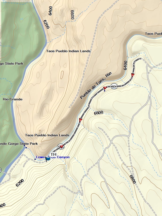
The Slide trail follows old Hwy. 570, which was closed in 1993 after tons of basalt rock slid down onto it — explaining the name. The southern end begins near the confluence of the Rio Pueblo and Rio Grande, and the now-cleared trail travels up the Rio Pueblo and ends high above it. The Rio Pueblo gorge is known as a migratory route for birds.
Comments
The track was obtained from the MTB Project website.
WaypointsTH: N36 20.263, W105 43.635
Map Filename: OrillaVerde-TheSlideMap_MW.jpgHike GPS File Name: OrillaVerde-TheSlideWayTrack_MW.gpx
Hike GPS File: Click link to download hike waytrack file
Text Author: Pam Bliss
Map Author: Marilyn Warrant
Waypoints Author: Marilyn Warrant
Track Author: Marilyn Warrant
Maintainer: Not Assigned
Editor: Marilyn Warrant