Rail Trail/Arroyo de los Chamisos Hike
In Santa Fe Region
Map File Source: Garmin BaseCamp
 Hike Key: H10665
Last Updated: 12/15/2020 12:00am
Last Updated By: Marilyn Warrant
Hike Class: C (Challenging)
Hike Distance: 6.1 mi
Minimum Elevation: 6660 ft
Elevation Change: 260 ft
Total Uphill: 260 ft
Total Downhill: 200 ft
Avg. Grade: 1 %
Route Type: Messy
On Trail: Yes
Paved or Gravel Roads: No
GPS Advised: No
Drive Distance Round Trip: 0 mi
Drive Time One-Way: 1:15
Hiking Seasons: Spring, Summer, Fall, and Winter
New Mexico Game Unit: 44
Hike Status: In Process
Highlights
This is a Railrunner Special hike. Hikers will depart from the train station closest to their home. Arrival at Zia Station is at 11:01. Lunch will be at 2nd Street Brewery. Return trip on the Railrunner. Bring money for lunch and train fare or buy train fare online. Contact Cathy to sign up 514-2857
CautionsThe train for this hike departs starting at the downtown station. Those who live further south will have to choose a station either downtown or any station further north. No bathroom at Zia Station.
Trailhead Directions
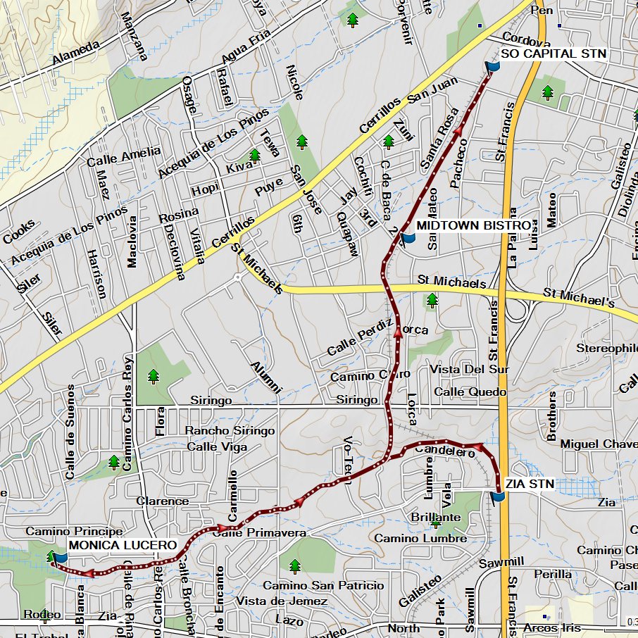
We will disembark from the train at the Zia station at 11:01. We then cross Zia Road and walk the Rail Trail to the junction of the Arroyo de los Chamisos trailhead. We will hike to Monica Lucero Park. We will return the same route and at the junction continue north on the Rail Trail to San Mateo Street where we will stop for lunch. After lunch we will take the short jaunt to the South Capitol Station where we will get on the southbound train at 4:20.
Actual Hike
This hike does not start at a senior center. The departure point is a train station starting from downtown depot or station nearest you. All hikers will disembark at Zia station at 11:01 and await the hike leader. We will head north on the Rail Trail across Zia Road to the junction of the Arroyo de los Chamisos Trail near Siringo Road. We will head west on the Arroyo de los Chamisos Trail at the junction of the two trails to Monica Lucero Park 2.5 miles. We return on the same trail. At the junction of the Rail Trail we head north and continue to San Mateo Street where we will have lunch at 2nd Street Brewery- 2.8 miles. We then will continue to the South Capitol Station .8 for a train departure time of 4:20 p.m. You will arrive at your destination sometime after 5:30.
Special Notes:
There is no bathroom facility until we reach Monica Lucero Park. We will have to cross over to the Genoveva Chavez Community Center. This is an all pavement path with heavy bicycle use so be courteous to bicyclists. There is a major street crossing at St. Michael’s with no dedicated crosswalk.
Comments
Lunch is late for this hike – after 1:30 so bring snacks to eat at the park or eat a late breakfast. Departure is not the usual time and the return will be late.
WaypointsZIA STN: N35 38.785, W105 57.421
MONICA LUCERO: N35 38.559, W105 59.436
MIDTOWN BISTRO: N35 39.739, W105 57.833
SO CAPITAL STN: N35 40.373, W105 57.443
Hike GPS File Name: ArroyoDeLosChamisosWayTrack_MW.gpx
Hike GPS File: Click link to download hike waytrack file
Text Author: Cathy Intemann
Map Author: Marilyn Warrant
Waypoints Author: Marilyn Warrant
Track Author: Marilyn Warrant
Maintainer: Cathy Intemann
Editor: Howard Carr