La Tierra Trails North Loop Hike
In Santa Fe Region
Map File Source: Garmin BaseCamp
 Hike Key: H10662
Last Updated: 10/06/2021 12:00am
Last Updated By: Marilyn Fixer
Hike Class: B (Moderate)
Hike Distance: 4.7 mi
Minimum Elevation: 6980 ft
Elevation Change: 225 ft
Total Uphill: 500 ft
Total Downhill: 500 ft
Avg. Grade: 5 %
Route Type: CW Loop
On Trail: Yes
Paved or Gravel Roads: No
GPS Advised: No
Drive Distance Round Trip: 120 mi
Drive Time One-Way: 1:00
Hiking Seasons: Spring, Fall, and Winter
New Mexico Game Unit: 6C
Hike Status: In Process
Highlights
This hike is part of the La Tierra Trail system three miles from the Santa Fe Plaza. Since there is no good place to lunch we will drive down to the Santa Fe River on Alameda for grass and shade. Maps are available online or from the City of Santa Fe.
CautionsSome short steep hills with loose dirt and gravel. Some hikers may wish to use poles.
Trailhead Directions
Go north on I-25 and exit at mile marker 276 onto NM Highway 599 or Veteran’s Highway. Go west and drive 11.3 miles to the La Tierra Trails, Camino de los Montoyas on the west or left side of the road. Drive another 2.8 miles and you will arrive at the Calabasas Trailhead. The hike begins across the parking lot. Look for the trail marker #1.
Actual Hike
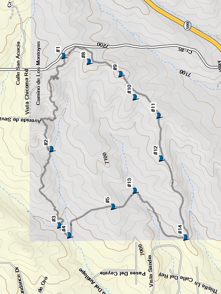
The hike is a 5 mile loop following the following trail route #1, #2 , #3, #4 , #5, #13, #14, #12,#11, #10, #9, #8, #1 and return to the parking lot.
Comments
This is a multi-use trail for bikes and equestrians so it is important to be aware of others using the trail. There are multiple options for hikes of varying lengths and the routes are well-marked with maps placed throughout the trail system; Santa Fe County provides a map of the La Tierra Trails system.
The hike map was derived from trail intersections on the brochure and Santa Fe County Trails tracks.
WaypointsPARK: N35 43.386, W105 57.806
Map Filename: LaTierraTrailsNorthLpMap2_MW.jpgHike GPS File Name: LaTierraTrailsNorthLp_MW-1.gpx
Hike GPS File: Click link to download hike waytrack file
Text Author: Cathy Intemann
Map Author: Marilyn Warrant
Waypoints Author: Marilyn Warrant
Track Author: Marilyn Warrant
Maintainer: Cathy Intemann
Editor: Howard Carr