Bisti South Hike
In Northwest New Mexico Region
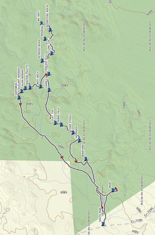
Map File Source: Garmin BaseCamp
 Hike Key: H10658
Last Updated: 03/26/2021 12:00am
Last Updated By: Dawn McIntyre
Hike Class: B (Moderate)
Hike Distance: 6.7 mi
Minimum Elevation: 5750 ft
Elevation Change: 63 ft
Total Uphill: 444 ft
Total Downhill: 444 ft
Avg. Grade: 1 %
Route Type: CCW Loop
On Trail: No
Paved or Gravel Roads: No
GPS Advised: Yes
Hiker Limit (NF/BLM/NP): 8 (BLM Wilderness)
Drive Distance Round Trip: 340 mi
Drive Time One-Way: 3:15
Hiking Seasons: Spring, Fall, and Winter
New Mexico Game Unit: 7
Hike Status: Waiting Editor
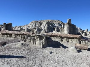
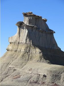
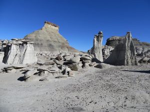
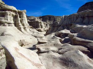
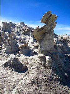
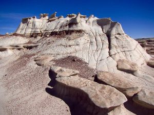
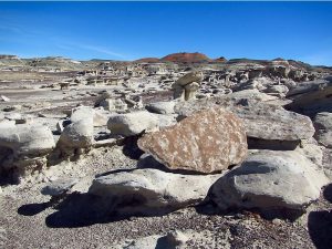
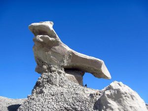
Attractions: Badlands and Rock Formations
Highlights
Premier mesa/badlands hike. A photographer’s dream.
CautionsLittle shade. Trekking poles recommended.
Trailhead Directions
From Albuquerque take I-25 north to Bernalillo. Go west on US 550 through San Ysidro, thru Cuba, thru Counseler, thru Lybrook. As Heufano Mesa is approached, pass the Indian Medical facility and near the top of the hill there will be a sign “Bisti – De Na Zin”. Go left and travel dirt CR 7500 for 25 miles to a SR 371 and go north. Go 8 miles on SR 371 to IR 7295 and turn right. Go 2 miles to a T and turn left. Go 1.2 miles to SOUTH PARK and park on the right in the small parking area.
Actual Hike
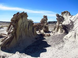
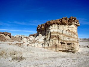
From the parking lot (SOUTH PARK), as you walk east up the wash, there are a few dips to navigate on the way to the first group of interesting rocks at BONEYARD (0.7 mi). See if you can you pick out the formation referred to as The Seal. For the most part, the GPX track follows close to the ridge on the south side. Continue to HOODOOS (1.3 mi), then to TOAD STOOLS (1.4 mi), then to DEBRIS FIELD (1.6 mi) which has a strange assortment of sometimes small but interesting shapes. Take time to wander around each of these areas.
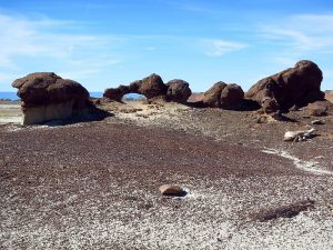
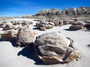
Continue to FLAT TOP (1.7 mi), on to GNARLY (2.1 mi), then to CRACKED EGGS (2.3 mi). Take time to wander through these unique rocks that are also superb photo opportunities. Continue on to LONG LOG (2.6 mi) and explore this area with multiple large and small logs of petrified wood. PEDERNAL (2.8 mi) is a large rock formation that looms ahead. Look for more petrified wood in this area. As you proceed, look north for a large butte with a BIG NEST (3.1 mi) on the west side (a large abandoned hawk nest). This is also the turn around point.
Lunch can be at any picturesque spot on this hike, but if it’s hot and you need shade, take advantage of anything you can find. Shade is scarce.
Wander back to CRACKED EGGS (3.9 mi) then turn NW for a short distance to BISTI ARCH (4.1 mi). The arch is not as large as you would expect so it’s possible to walk by and not notice. PAINTERS PALETTE (4.2 mi) is an interesting area to browse for its unique color contrast and multi-colored variations. Just beyond is an area that looks like someone planted a “rock garden”.
Not far are a couple interesting formations that are grouped fairly close– ALIEN WOMAN, ELEGANT HOODOO (4.4 mi), and a bit further is a large formation that looks like VERTEBRAE (4.5 mi). The next 1.5 miles is not particularly interesting until you enter the MAZE (6.1 mi). Take time to wander through and over the toad stool formations. There are interesting views if you climb to the top of some. Most pathways in this maze are dead ends and some can be quite dangerous to navigate so proceed with caution. From here it’s a short walk back to SOUTH PARK (6.7mi).
Comments
The MAZE area can be explored at the beginning of the hike or near the end. In the hike description and on the GPX track, it is near the end.
This is a Federal Wilderness Area with special restrictions, and is administered by the Farmington BLM Office. Group size is limited to 8 people. Break the hikers into groups and hike in opposite directions if there are more than 8 people. See the Bisti/De-Na-Zin website.
WaypointsTO SOUTH PARK: N36 13.911, W108 16.294
SOUTH PARK: N36 15.560, W108 15.105
BONEYARD: N36 15.714, W108.14.377
HOODOOS: N36 15.772, W108 14.170
TOAD STOOLS: N36 15.828, W108 14.082
DEBRIS FIELD: N36 15.933, W108 13.992
FLAT TOP: N36 15.986, W108 13.973
GNARLY: N36 16.042, W108 13.605
CRACKED EGGS: N36 16.044, W108 13.425
PETRIFIED WOOD: N36 16.105, W108 13.277
LONG LOG: N36 16.019, W108 13.195
PEDERNAL: N36 16.079, W108 13.033
INTERESTING ROCKS: N36 16.033, W108 12.931
BIG NEST: N36 16.111, W108 12.861
BISTI ARCH: N36 16.118, W108 13.567
PAINTERS PALETTE: N36 16.213, W108 13.579
ALIEN WOMAN: N36 16.255, W108 13.586
ELEGANT HOODOO:
VERTABRAE: N36 16.312, W108 13.690
MAZE: N36 15.472, W108 14.727
Hike GPS File Name: BistiSouth_DMDM.gpx
Hike GPS File: Click link to download hike waytrack file
Text Author: Dawn McIntyre
Map Author: Dawn McIntyre
Waypoints Author: Dawn McIntyre
Track Author: Dawn McIntyre
Maintainer: Dawn McIntyre
Editor: Marilyn Warrant