Sabinoso Wilderness Hike
In Conchas Region
Map File Source: DeLorme
 Hike Key: H10627
Last Updated: 06/29/2021 12:00am
Last Updated By: Marilyn Fixer
Hike Class: C (Challenging)
Hike Distance: 7.9 mi
Minimum Elevation: 5412 ft
Elevation Change: 550 ft
Total Uphill: 617 ft
Total Downhill: 617 ft
Avg. Grade: 4 %
Route Type: InOut
On Trail: Yes
Paved or Gravel Roads: No
GPS Advised: No
Drive Distance Round Trip: 342 mi
Drive Time One-Way: 2:45
Hiking Seasons: Spring, Summer, and Fall
New Mexico Game Unit: 42
Hike Status: Published
Highlights
This hike contains beautiful canyons, river crossings, and the opportunity to see wildlife.
CautionsThere is a 3/4 mile steep (up to 24% grade) rocky road down to and back up from the canyon trail. Hiking poles and boots with good tread are advised. Bring water shoes if higher water is expected.
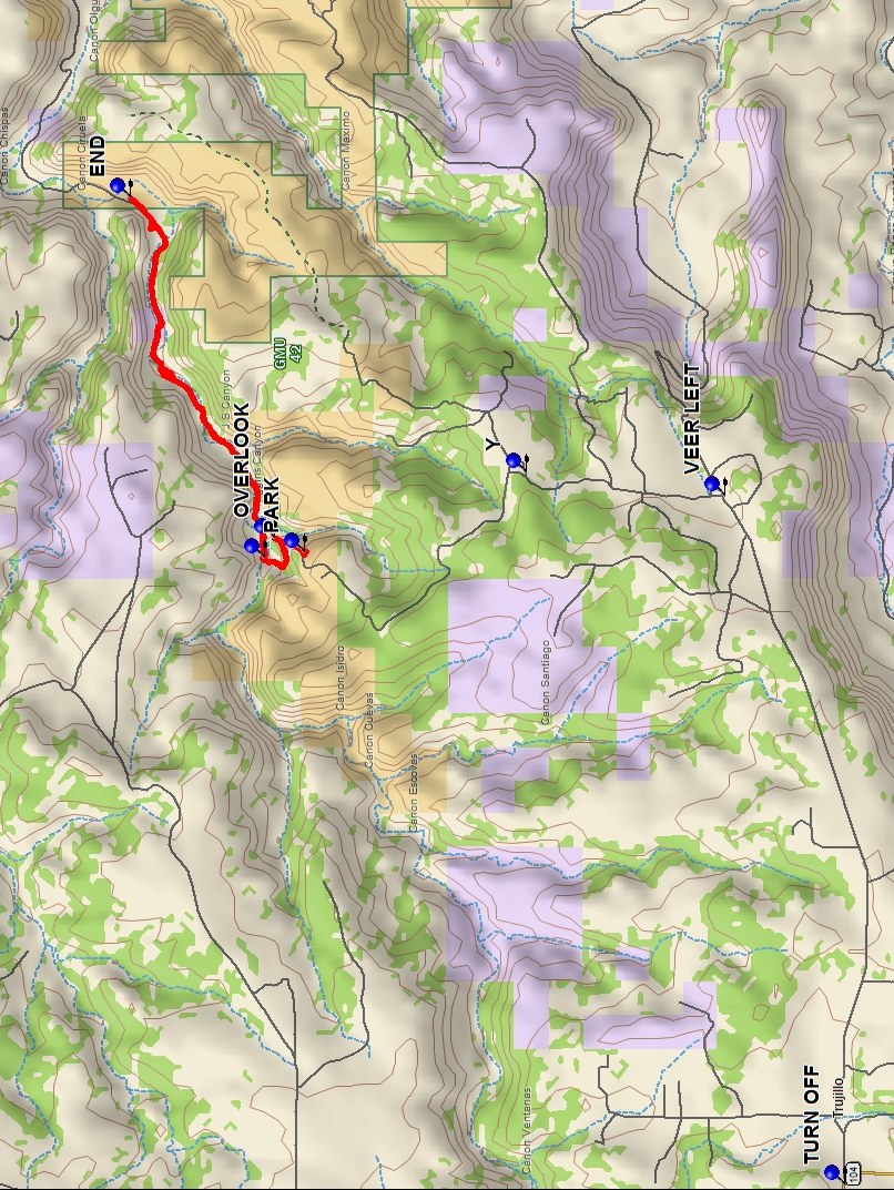
Trailhead Directions
I-25 north to Exit 345 in Las Vegas. Turn right and go east on NM 104 for 32.7 miles to waypoint TURN OFF and go straight on gravel road through Trujillo, NM (high clearance vehicles recommended from here and we advise not to travel the road when wet). From here continue on C51A east for approximately 7 miles. At Y intersection, follow BLM directional signs to the left and head north for 3 miles to the Sabinoso Wilderness parking area. Make sure to reclose all the gates you have to go through.
Actual Hike
From PARK start down the somewhat steep, rutted, rocky dirt road to the OVERLOOK (0.4 mi) for great views of the Largo Canyon you will be hiking through. Next continue down the bad road to the gate. Go through the gate and relatch it. CROSS (0.8 mi) the stream then continue to the right and follow the dirt road over the many stream crossings to the turnaround waypoint END (4.0 mi). Continue back the way you came to PARK. The dirt road through the canyon continues for several more miles if you want a longer hike.
Comments
Public access to this 2009 wilderness area was finally granted in November 2017. When the river is low you can make the several crossings from rock to rock; however, debris on shoreline rocks and trees indicate that the river may be 5-6 feet higher at times. Don’t schedule this hike during big game hunting season!
The access road is not advisable when wet. For current status on water levels and road status, call the BLM at 575-758-8851.
The canyon has been home to ancestral Pueblo peoples, a wagon route for the 19th century U.S. Army, a homestead for sheep and cattle operations and since the late 20th century a gentleman’s cattle ranch.
WaypointsAccess
TURN OFF: N35 32.096, W104 41.976
VEER LEFT: N35 32.868, W104 36.534
Y: N35 34.142, W104 36.343
Hike
PARK: N35 35.570, W104 36.980
OVERLOOK: N35 35.759, W104 36.862
CROSS STREAM: N35 35.828, W104 37.025
TURN AROUND: N35 36.688, W104 34.169
Hike GPS File Name: SabinosoWildernessWayTrack_FE.gpx
Hike GPS File: Click link to download hike waytrack file
Text Author: Frank Ernst
Map Author: Marilyn Warrant
Waypoints Author: Frank Ernst
Track Author: Frank Ernst
Maintainer: Not Assigned
Editor: Howard Carr