Gutierrez-Hubbell House + acequias Hike
In Albuquerque Region
Map File Source: Garmin BaseCamp
 Hike Key: H10613
Last Updated: 06/29/2021 12:00am
Last Updated By: Marilyn Fixer
Hike Class: A (Easy)
Hike Distance: 4 mi
Minimum Elevation: 4920 ft
Elevation Change: 4 ft
Total Uphill: 4 ft
Total Downhill: 4 ft
Avg. Grade: %
Route Type: Messy
On Trail: Yes
Paved or Gravel Roads: Yes
GPS Advised: No
Drive Distance Round Trip: 26 mi
Drive Time One-Way: 0:30
Hiking Seasons: Spring, Fall, and Winter
New Mexico Game Unit: 9
Hike Status: In Process
Highlights
Visit to Historic Gutierrez-Hubbell History and Cultural Center located in the Pajarito agricultural area of the South Valley. The house/center dates back to the 1860s and symbolizes the mixing of Spanish, Anglo, and Native American traditions and cultures during the Territorial Periods, 1846- 1912.
CautionsNone.
Trailhead Directions
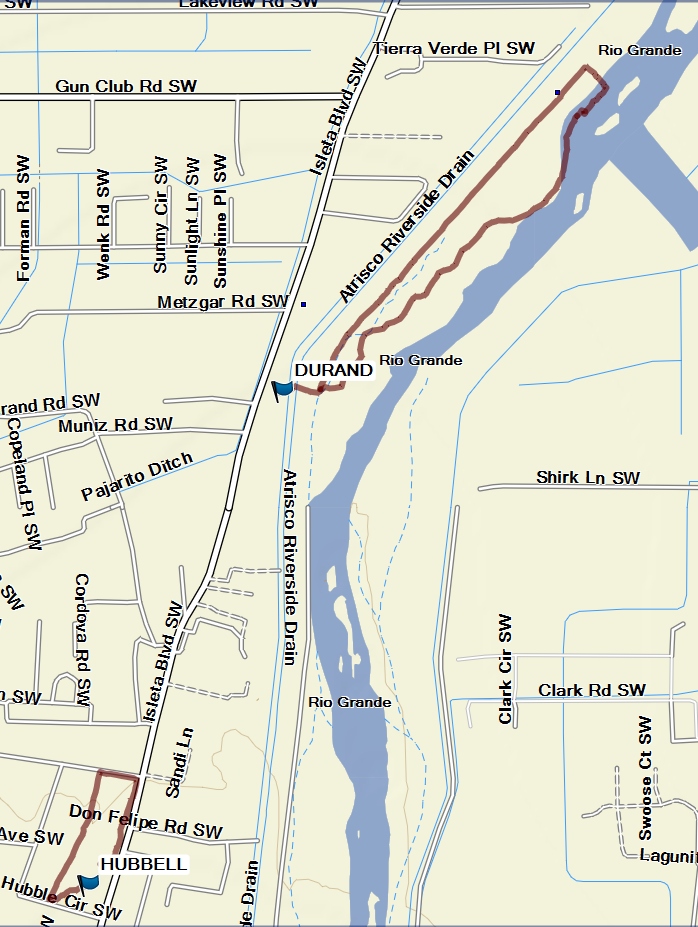
I-25 South to Exit 220, Rio Bravo Blvd, go west (turn right at end of ramp). Continue 2.5 miles to the Isleta Blvd traffic light and go south (turn left). Travel 2 miles to Durand Open Space, and hike to Rio Grande Bosque. Travel 1 mile to the Museum on the right, just past Don Felipe Rd.
Actual Hike
The hike consists of three parts. First, hike along the Rio Grande Bosque West Side in the Durand Open Space. Hopefully we will be able to see some Canadian Geese and other migrating birds along the river. The hiking trail is flat and sandy. Second, visit the Gutierrez-Hubbell House Center (see website) for a presentation and museum visit. Have lunch on the picnic tables around the center. Third, walk around the Center grounds and Pajarito Open Space. There is a shop with delicious ice cream across the street from the Center in case you are in the mood for dessert. Museum changes $2.00 entrance fee.
Comments
The Gutierrez-Hubbell House Center is a 5,748 sf adobe structure that dates back to the mid 1850s. Constructed in stages, it has facades, thresholds, walls, vigas, nichos, canals, windows, rim and transoms that characterize New Mexico Territorial architecture.
WaypointsDURAND: N35 00.198, W106 41.379
PARK-HUBBELL: N34 59.341, W106 41.799
Hike GPS File Name: Gutierrez-Hubbell Acequia Madre(3).gpx
Hike GPS File: Click link to download hike waytrack file
Text Author: Carmen Graham
Map Author: Marilyn Warrant
Waypoints Author: Vivian Heyward
Track Author: Vivian Heyward
Maintainer: Cathy Intemann
Editor: