Las Conchas Short Hike
In Jemez Mountains Region
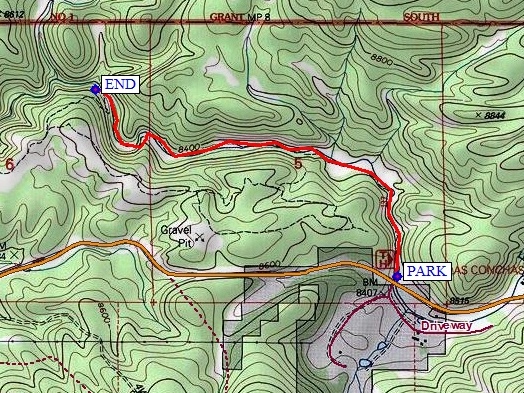
Map File Source: NG Topo
 Hike Key: H10610
Last Updated: 12/15/2020 12:00am
Last Updated By: Marilyn Warrant
Hike Class: A (Easy)
Hike Distance: 3.1 mi
Minimum Elevation: 8320 ft
Elevation Change: 110 ft
Total Uphill: 240 ft
Total Downhill: 240 ft
Avg. Grade: 5 %
Route Type: InOut
On Trail: Yes
Paved or Gravel Roads: Yes
GPS Advised: No
Drive Distance Round Trip: 160 mi
Drive Time One-Way: 2:00
Hiking Seasons: Spring, Summer, and Fall
New Mexico Game Unit: 6A
Hike Status: Published
Highlights
Mountain stream in narrow canyon; many river crossings (with bridges). Dramatic rock formations, wildflowers in summer, good aspen fall color.
CautionsNone.
Trailhead Directions
I-25 N to exit 242, W on US 550 to San Ysidro, right (north) on SR 4 to La Cueva. Take SR 4 12.4 mi. east of La Cueva to Las Conchas C.G.
Actual Hike
Walk down Las Conchas Canyon. This small canyon is very scenic. There are many crossings of the river, all of them rebuilt as wood foot bridges. Enjoy the wildflowers, the rocks, and the occasional climber, fisherman, or wader.
Comments
This hike may be combined with the Walatowa Red Rocks tour, the hike to Jemez Falls, or a short hike in the Valles Caldera.
WaypointsPARK: N35 48.921, W106 31.970
END: N35 49.469, W106 33.056
Hike GPS File Name: LasConchasShortWayTrack_MW.gpx
Hike GPS File: Click link to download hike waytrack file
Text Author: Joan Weissman
Map Author: Marilyn Warrant
Waypoints Author: Marilyn Warrant
Track Author: Marilyn Warrant
Maintainer: Joan Weissman
Editor: Howard Carr