Chaco Canyon NHP — Pueblo Alto Trail Hike
In Northwest New Mexico Region
Map File Source: NG Topo
 Hike Key: H10562
Last Updated: 12/15/2020 12:00am
Last Updated By: Marilyn Warrant
Hike Class: C (Challenging)
Hike Distance: 5.5 mi
Minimum Elevation: 6104 ft
Elevation Change: 384 ft
Total Uphill: 1111 ft
Total Downhill: 1111 ft
Avg. Grade: 8 %
Route Type: Lollypop
On Trail: Yes
Paved or Gravel Roads: No
GPS Advised: No
Drive Distance Round Trip: 306 mi
Drive Time One-Way: 3:15
Hiking Seasons: Spring, Fall, and Winter
New Mexico Game Unit: 7
Hike Status: Published
Highlights
Chaco Canyon NHP, a World Heritage Site since 1987, should definitely be on your bucket list, especially doing it at low cost, being with a group of friends and not having to drive..
CautionsThe two slot canyons are narrow and steep. Those with knee problems beware. Be prepared with plenty of water, skin cover and sunscreen.
Trailhead Directions
From Albuquerque take I-25 north to Bernalillo. Go west on US 550 through San Ysidro, thru Cuba (reset the odometer here). Go about 48.5 miles from Cuba (or 12 mi past Counselors, NM) to the “Chaco Culture” sign and turn left (at “Chaco Left” on your gpx waytrack). Drive 5 mi south and then take a right turn onto a dirt road, but well-marked for Chaco Canyon. Travel another 15 mi over gravel or dirt roads until you reach the Visitor Center. There you will need to get out of the van and sign-in at the Chaco Canyon National Historic Park (NHP). Then take a one-way paved road for nearly four miles to PARK (0.0 mi).
Actual Hike
First, a suggestion: If you are able to find a second hike leader and enough time to plan, consider offering the hikers one of two options: 1) a strenuous 5.5 mi hike with beautiful views of several pueblos from the top of the mesa; or 2) a more leisurely tour of a few pueblos up close, a shorter hike and an opportunity to spend more time in the Visitors Center and possibly participate in a Ranger lecture. And if you have the luxury of two vans, some hikers may leave earlier and the others later.
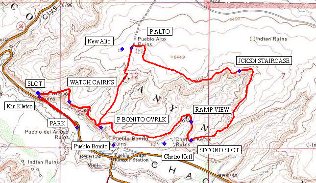
From PARK (0.0 mi) walk to view the Kin Kletso ruin. Take your time and then go beyond to immerse yourself up into the SLOT (0.4 mi). From the summit of the mesa work toward WATCH CAIRNS (0.7 mi) which reminds us how easily we can get lost by distraction. P BONITO OVRLK (1.0 mi) is a good place to eat lunch and enjoy the spectacular view of Pueblo Bonito, the “Beautiful Town” built in about CE 850 to 1150.
Following lunch, hike north along the Chacoan Road (the same old one) to P Alto (1.7 mi). You may have time to visit New Alto as well as Pueblo Alto in order to compare the two different architectural periods. Then walk east to JCKSN STAIRCASE (2.6 mi) to view the actual Chacoan steps across the canyon. Keep traveling along the top of the mesa until reaching the SECOND SLOT (3.5 mi) where your agility and balance will again come into play. Not long after coming out you will come to RAMP VIEW (3.6 mi), not too exciting. After hiking around the mesa on top of the Ramp and beyond, you will come to a pleasing view of the Chero Ketl, an astronomical aligned great house ruin, down below.
You’ll finish the loop just above your previous lunch spot, P BONITO OVRLK (4.5 mi) and then you will retrace your steps back to the vehicle at PARK (5.5 mi).
Comments
The following locations are included on the WayTrack in order to assist in locating useful sites and places.
Counselors: N36 13.636, W107 30.646
Chaco Left: N36 14.475, W107 42.392
Visitor Ctr: N36 01.809, W107 54.623
Fajada Butte: N36 01.143, W107 54.593
Hungo Pavi: N36 02.969, W107 55.818
Casa Rinconada: N36 03.288, W107 57.603
Tsin Kletzin: N36 02.189, W107 57.477
Wijiji TH: N36 01.940, W107 53.523
Wijiji: N36 01.562, W107 52.170
Call the visitor center at (505) 786-7014 ext. 221 to find out the times of the ranger-led tours of the ruins west of the visitor center for the date(s) you plan to visit. There are also night sky programs for some days of the week if you plan to camp overnight. Fees for vehicle access and camping are here. Seniors get a significant discount. Bring your Gold Passes (one works for every four seniors).
WaypointsPARK: N36 03.719, W107 57.905
SLOT: N36 03.926, W107 58.196
WATCH CAIRNS: N36 03.874 W107 57.962
P BONITO OVRLK: N36 03.717, W107 57.729
P ALTO: N36 04.195, W107 57.503
JCKSN STAIRCASE: N36 04.059, W107 56.711
SECOND SLOT: N36 03.642, W107 57.063
RAMP VIEW: N36 03.752 W107 57.065
Kin Kletso: N36 03.903, W107 58.185
Pueblo Bonito: N36 03.613, W107 57.640
New Alto: N36 04.190, W107 57.573
Chetro Ketl: N36 03.621, W107 57.263
Hike GPS File Name: 141016_Chaco Cyn NHP_BGBG.gpx
Hike GPS File: Click link to download hike waytrack file
Text Author: Frank Ernst
Map Author: Bill Gloyd
Waypoints Author: Bill Gloyd
Track Author: Bill Gloyd
Maintainer: Bill Gloyd
Editor: Howard Carr