Oat – Hay Canyons To Bottom Long Hike
In Jemez Mountains Region
Map File Source: DeLorme
 Hike Key: H10556
Last Updated: 03/04/2021 12:00am
Last Updated By: Marilyn Fixer
Hike Class: C (Challenging)
Hike Distance: 6.5 mi
Minimum Elevation: 8065 ft
Elevation Change: 740 ft
Total Uphill: 970 ft
Total Downhill: 970 ft
Avg. Grade: 8 %
Route Type: CCW Loop
On Trail: No
Paved or Gravel Roads: No
GPS Advised: Yes
Drive Distance Round Trip: 160 mi
Drive Time One-Way: 1:45
Hiking Seasons: Spring, Summer, and Fall
New Mexico Game Unit: 6A
Hike Status: Published
Highlights
Pleasant hike up the valley, then up Oat Canyon for a descent down Hay covered with wildflowers in the spring, to a sensational viewpoint, then down to the valley below.
CautionsUse of hiking poles is recommended for the descent to the bottom.
Trailhead Directions
From Albuquerque go north on I-25 to exit 242 (Bernalillo), west on US 550 to San Ysidro. North on SR 4 to La Cueva. Take SR 126 west about 9 mi. to Fenton Lake, keep going north 4 mi. until you come to the marked road to the Fish Hatchery on the right. Take this dirt road past the hatchery. At this point you may encounter a closed gate. Park here if the gate is closed. Otherwise continue past the gate for about one mile to a fence and corral and PARK (0.0 mi)
Actual Hike
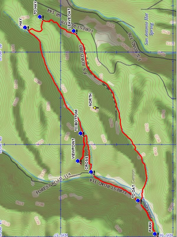
From parking go through the gate and follow the two track up the valley to TO OAT (0.4 mi). Turn right and go across the stream and go uphill toward the notch. Continue up the side canyon to the top and LEAVE OAT (2.4 mi), following the trail northward to TO HAY (2.8 mi) and turn left, following the two track to HAY (3.1 mi). Turn left again and hike down this pleasant pine lined valley which follows a broad ledge to the VIEWPOINT (4.7 mi). A great view and a good place for lunch. Then return uphill to TO BOTTOM (5.0 mi) and turn right downhill into a narrow notch and proceed down to the floor of the main canyon to CROSS (5.5 mi) the stream. Follow the two track down the valley to parking.
Waypoints
PARK: N35 56.134, W106 41.008
TO OAT: N35 56.283, W106 40.648
LEAVE OAT: N35 56.857, W106 38.810
TO HAY: N35 57.158, W106 38.659
HAY: N35 57.290, W106 38.775
TO BOTTOM: N35 56.795, W106 39.920
VIEWPOINT: N35 56.820, W106 40.219
CROSS: N35 56.701, W106 40.336
Hike GPS File Name: Oat-HayCanyonsToBottomLongWayTrack_DBDB.gpx
Hike GPS File: Click link to download hike waytrack file
Text Author: Dick Brown
Map Author: Dick Brown
Waypoints Author: Dick Brown
Track Author: Dick Brown
Maintainer: Marilyn Warrant
Editor: Marilyn Warrant