Powerline – Chamisoso Hike
In Cedro Peak Region
Map File Source: NG Topo
 Hike Key: H10540
Last Updated: 06/29/2021 12:00am
Last Updated By: Marilyn Fixer
Hike Class: C (Challenging)
Hike Distance: 7.4 mi
Minimum Elevation: 6557 ft
Elevation Change: 739 ft
Total Uphill: 1305 ft
Total Downhill: 1305 ft
Avg. Grade: 7 %
Route Type: Lollypop
On Trail: Yes
Paved or Gravel Roads: Yes
GPS Advised: No
Drive Distance Round Trip: 40 mi
Drive Time One-Way: 0:45
Hiking Seasons: Spring, Summer, and Fall
New Mexico Game Unit: 14
Hike Status: Published
Highlights
A beautiful northern exposure walk-around near the top of Cedro Peak in the woods.
CautionsIf you are not used to hiking D hikes, think twice before doing this one. There is a steep climb (18% grade) along the powerline.
Trailhead Directions
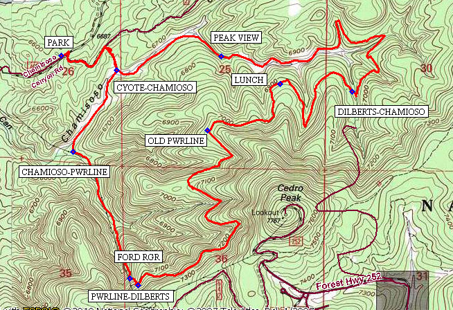
From Albuquerque take I-40 west to the Tijeras exit. Take SR 337 south through the traffic light for about 1.6 miles to Chamisoso Canyon Rd on your left. Take this dirt road east for about 0.6 mile. Park the van in the designated parking area PARK (0.0 mi), where there is a set of restrooms.
Actual Hike
From the parking area walk along the main road (462A) for 250 ft, where you will take a right turn off the main road, up a rocky side road for nearly a third of a mile. At this point you will find four large boulders (used to block vehicular traffic), where you will turn right (south) going downhill for approximately one tenth of a mile to the junction CYOTE-CHAMIOSO (620-184) (0.5 mi). The trails are well-marked with five digit numbers, starting with 05, so the above waypoint is where 05620 and 05184 meet.
At this point turn right and follow the Chamioso Canyon to the powerline, junction CHAMIOSO-PWRLINE (184-543)(9.0 mi). The trail up starts gradually, then reaches a slope of 18% for the last half-mile. Near the top of our climb is a welcome rest-stop and water-snack break, FORD RGR (1.7 mi). The trail keeps gaining altitude to the junction PWRLINE-DELBERTS (543-622)(1.8 mi). Delberts Trail (622) continues to go upward following a contour around the peak.
The half-way point of the hike is OLD PWRL (3.4 mi), where one can see the cleared area to Cedro Peak and all the way down in the other direction. There may be a number of choices for stopping to eat, but LUNCH (4.0 mi) is one option.
The next trail junction, DELBERTS-CHAMIOSO (622-184) (4.7 mi), winds around a star-like pattern in a hilly, woodsy area. PEAK VIEW (6.3 mi) is easy to miss, but will give the hikers one more opportunity to view Cedro Peak in its glory. One will find the junction CYOTE-CHAMIOSO (620-184)(6.9 mi) again and turn right to hike the last half-mile back to the van.
Comments
Hikers are encouraged to take trekking poles, plenty of water, and cover from sunshine. If there is still a chance for snow cover, boot pull-over steel cleats would be useful. Although this hike does not achieve a D rating by the numbers, some might feel that it should be so designated. The 0.5 mile strenuous climb at an 18% grade along the power line helps to make that argument.
In 2012-2013 the US Forest Service improved many of the Cedro Peak Region trails and their signage. This hike was derived from four such contiguous trails.
WaypointsPARK: N35 03.846, W106 22.280
CYOTE-CHAMIOSO: N35 03.784, W106 21.994
CHAMIOSO-PWRLINE: N35 03.438, W106 22.220
FORD RGR: N35 02.903, W106 21.927
PWRLINE-DILBERTS: N35 02.873, W106 21.886
OLD PWRL: N35 03.529, W106 21.526
LUNCH: N35 03.727, W106 21.153
DILBERTS-CHAMIOSO: N35 03.694 W106 20.782
PEAK VIEW: N35 03.844, W106 21.456
Hike GPS File Name: Pwrline-Chamioso Cyn01_BG.gpx
Hike GPS File: Click link to download hike waytrack file
Text Author: Bill Gloyd
Map Author: Bill Gloyd
Waypoints Author: Bill Gloyd
Track Author: Bill Gloyd
Maintainer: Bill Gloyd
Editor: Howard Carr