Cienega Petroglyphs Hike
In Santa Fe Region
Map File Source: DeLorme
 Hike Key: H10533
Last Updated: 12/05/2023 8:43pm
Last Updated By: Marilyn Fixer
Hike Class: A (Easy)
Hike Distance: 3 mi
Minimum Elevation: 6195 ft
Elevation Change: 180 ft
Total Uphill: 180 ft
Total Downhill: 180 ft
Avg. Grade: 3 %
Route Type: InOut
On Trail: No
Paved or Gravel Roads: Yes
GPS Advised: No
Drive Distance Round Trip: 100 mi
Drive Time One-Way: 1:00
Hiking Seasons: Spring, Summer, Fall, and Winter
New Mexico Game Unit: 6C
Hike Status: Published
Highlights
Interesting collection of petroglyphs at the end of a pleasant canyon hike.
CautionsDo not go on this hike if you have balance problems, as the area where the petroglyphs are located is steep and rocky.
Trailhead Directions
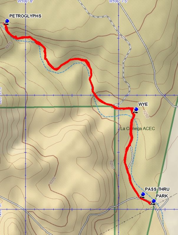
I-25 north to the La Cienega Exit 271. Go northwest about 1 mile into the village of La Cienega on Entrada La Cienega (NM587). After passing through the village, turn right onto Los Pinos Rd (CR54). Follow Los Pinos Rd (CR54) for 1.2 miles to Las Golondrinas. At this point drive straight onto Paseo Real (CR56). Follow Paseo Real (CR56) for 2.8 miles to CR56C. Bear left onto CR56C and follow CR56C for 0.6 miles. The trailhead parking area (PARK) is on the left side of the road. After the cattle guard there is a small parking area on the right with an information board. PARK here.
Actual Hike
From parking walk up the road to the PASS THRU (0.1 mi) and hike the two track north west to the WYE (0.5 mi). At this point go to the left ( the right branch goes uphill out of the canyon) and continue to the PETROGLYPHS (1.5 mi) which are at canyon floor level. After enjoying the petroglyph panels there return the way you came to parking.
Waypoints
PARK: N35 37.022, W106 07.329
PASS THRU: N35 37.053, W106 07.387
WYE: N35 37.425, W106 07.424
PETROGLYPHS: N35 37.812, W106 08.117
Hike GPS File Name: CienegaPetroglyphsWayTrack_DBDB.gpx
Hike GPS File: Click link to download hike waytrack file
Text Author: Dick Brown
Map Author: Dick Brown
Waypoints Author: Dick Brown
Track Author: Dick Brown
Maintainer: John Cooper
Editor: Randy Simons