Tecolote Peak Hike
In Sandia Mountain East Region
Map File Source: DeLorme
 Hike Key: H10518
Last Updated: 12/06/2023 6:42pm
Last Updated By: Marilyn Fixer
Hike Class: B (Moderate)
Hike Distance: 2.4 mi
Minimum Elevation: 8635 ft
Elevation Change: 190 ft
Total Uphill: 320 ft
Total Downhill: 320 ft
Avg. Grade: 6 %
Route Type: InOut
On Trail: Yes
Paved or Gravel Roads: Yes
GPS Advised: Yes
Drive Distance Round Trip: 50 mi
Drive Time One-Way: 0:30
Hiking Seasons:
New Mexico Game Unit: 8
Hike Status: Published
Highlights
Easy hike in the Sandia mountains with views to the east.
CautionsNone.
Trailhead Directions
Cedar Crest and then left onto the SR 536 (Sandia Crest Scenic Byway). After Doc Long and milepost 5 you’ll find Tree Springs on the left. Look over to the right and that is Tecolote Peak. Go about a half a mile and turn right just after milepost 6.
Actual Hike
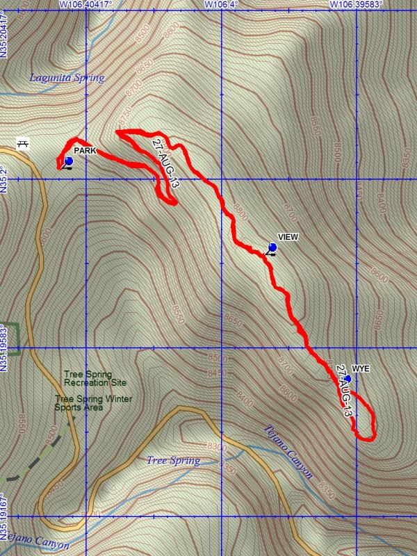
Tecolote Peak is a relatively new hike and is not on the map. Great place for wild flowers. The trail goes out from the north end of parking and is well marked. It is maintained by the Friends of the Forest. It goes up the right (west) side of Tecolote, and after a while you can get a good view of the Sandia Crest on your right, with the Ski Lift and a little later, the electronic site, then you can see the road you came up on and the parking area for Tree Springs. After switchbacks to the left, you will be on top and will proceed in a generally south direction to an overlook on your left at VIEW (0.8 mi) (not marked) where you can see left to the east and north. Now you will be going gently down and in shortly you will be at the WYE (1.1 mi) where there is a sign for the 1/4 mi. loop. You can see to the east and southeast from here. At the end of the loop you can see the winding Crest Highway climbing below. At this point it is interesting to note that we are nearly at the same elevation as we started. The peak really isn’t much of a peak, but rather a long, gradually descending strip with a 5′ mound at its highest point. Great views of all of the Sandias, though. In other places in the Sandias the view is blocked by trees.
Waypoints
PARK: N35 12.016, W106 24.297
VIEW: N35 11.888, W106 23.921
WYE: N35 11.693, W106 23.783
Hike GPS File Name: TecolotePeakWayTrack_DBDB.gpx
Hike GPS File: Click link to download hike waytrack file
Text Author: Roger Holloway
Map Author: Dick Brown
Waypoints Author: Dick Brown
Track Author: Dick Brown
Maintainer: Cindy McConnell
Editor: Randy Simons