Ellis – 10K – Survey Loop Hike
In Sandia Mountain East Region
Map File Source: DeLorme
 Hike Key: H10511
Last Updated: 03/20/2023 2:22pm
Last Updated By: Marilyn Fixer
Hike Class: B (Moderate)
Hike Distance: 4.5 mi
Minimum Elevation: 9850 ft
Elevation Change: 570 ft
Total Uphill: 580 ft
Total Downhill: 580 ft
Avg. Grade: 7 %
Route Type: CCW Loop
On Trail: Yes
Paved or Gravel Roads: Yes
GPS Advised: No
Hiker Limit (NF/BLM/NP): 15 (Sandia Wilderness)
Drive Distance Round Trip: 60 mi
Drive Time One-Way: 1:00
Hiking Seasons: Spring, Summer, and Fall
New Mexico Game Unit: 8
Hike Status: Published
Highlights
Nice views to east. Good hike for wildflowers and butterflies. Return trail nicely shaded.
CautionsNone.
Trailhead Directions
From Albuquerque go east on I-40 to the SR 14 exit and go north to Cedar Crest. At SR 536 turn left and go up the crest road 11.7 miles to The Ellis Trailhead PARK on your left. A three dollar fee or Golden Age Pass is required.
Actual Hike
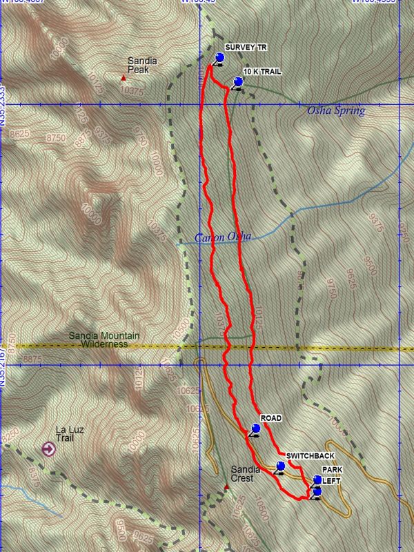
From PARK go north, crossing the highway. The hike follows the cutting for a road intended to go to the Sandia North Peak area. The road was never completed. The trail intersects the 10 K TRAIL (2.0 mi) after up and down travel. Turn left onto the 10K trail which goes up to the intersection with the SURVEY TR (2.2 mi) and go left on that trail. This trail gains elevation at a moderate rate and reaches the state ROAD (4.0 mi). The trail officially ends here. Cross the highway and go downhill on the trail. The SWITCHBACK (4.2 mi) trail joins from the right. Go straight; this is now the Switchback Trail. At LEFT (4.4 mi), leave the Switchback Trail. Arrive at the service road and go left to the parking lot.
Comments
The Ellis segment of this hike is in the open. The Survey segment of this hike is in the trees.
WaypointsPARK: N35 12.530, W106 26.454
10K TRAIL: N35 14.057, W106 26.852
SURVEY TR: N35 14.151, W106 26.945
ROAD: N35 12.727, W106 26.763
SWITCHBACK: N35 12.583, W106 26.639
LEFT: N35 12.487, W106 26.456
Hike GPS File Name: Ellis-10K-SurveyLoopWayTrack_DBDB.gpx
Hike GPS File: Click link to download hike waytrack file
Text Author: Dick Brown
Map Author: Dick Brown
Waypoints Author: Dick Brown
Track Author: Dick Brown
Maintainer: Not Assigned
Editor: Marilyn Warrant