Ghost Ranch – Matrimonial Mesa Loop Hike
In Ghost Ranch Region
Map File Source: DeLorme
 Hike Key: H10480
Last Updated: 06/29/2021 12:00am
Last Updated By: Marilyn Fixer
Hike Class: C (Challenging)
Hike Distance: 2.5 mi
Minimum Elevation: 6290 ft
Elevation Change: 245 ft
Total Uphill: 420 ft
Total Downhill: 420 ft
Avg. Grade: 6 %
Route Type: CCW Loop
On Trail: No
Paved or Gravel Roads: Yes
GPS Advised: Yes
Drive Distance Round Trip: 235 mi
Drive Time One-Way: 2:15
Hiking Seasons: Spring and Fall
New Mexico Game Unit: 51
Hike Status: Published
Highlights
Hike a colorful canyon to views of the Ghost Ranch area.
CautionsThis hike is off-trail and the ascent into the back area of the hike is difficult.
Trailhead Directions
From Albuquerque, take I-25 to Santa Fe, then US 84/285 to Espanola. Continue north on US 84/285 north, staying on US 84 when US 285 splits off about 5 mi from town. Continue about 33 miles through Abiquiu to a parking area on the left with access roads at both ends and PARK.
Actual Hike
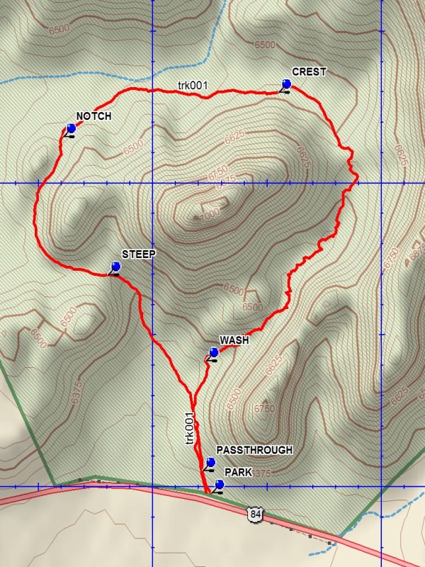
From PARK cross the highway to the north side and go through the PASSTHROUGH (150 ft). Continue north staying to the east side of the flat. On your left will be badlands formations with the best color in the area. Stay in the WASH which will take you into a interesting but difficult section. Pick your way up, through, and under the boulders as you begin to have the eerie feeling “what am I doing here”. After about 0.2 miles things start to get better. There is Matrimonial Mesa towering on the left and high cliffs to the right and ahead. As you work your way up the narrow wash the cliffs ahead seem to stretch out, curving to the left, forever. But eventually things open up and at the CREST there are views of the familiar formations of Ghost Ranch. Then stay at the base of Matrimonial as you curve around to a NOTCH. Going through the notch you will arrive at STEEP where you must go down the colorful badlands you saw on the way in. Stay in the small wash so as to not damage this scenic area. Follow the wash out the bottom and head for parking.
Comments
There is now a $10 user fee to hike on Ghost Ranch. Day visitors are asked to reserve in advance.
The rating has been raised to a C hike. It is off-trail and the ascent into the back area of the hike is difficult. Since the hike is short do this hike in conjunction with another hike in the area such as one of the Ghost Ranch hikes or the Plaza Blanca hike.
WaypointsPARK: N36 18.490, W106 27.373
PASSTHROUGH: N36 18.526, W106 27.393
WASH: N36 18.707, W106 27.386
CREST: N36 19.150, W106 27.227
NOTCH: N36 19.077, W106 27.698
STEEP: N36 18.849, W106 27.600
Hike GPS File Name: GhostRanch-MatrimonialMesaLoopWayTrack_DBDB.gpx
Hike GPS File: Click link to download hike waytrack file
Text Author: Dick Brown
Map Author: Dick Brown
Waypoints Author: Dick Brown
Track Author: Dick Brown
Maintainer: Not Assigned
Editor: Howard Carr