White Mesa – East Ridge Hike
In Ojito Region
Map File Source: DeLorme
 Hike Key: H10472
Last Updated: 12/06/2023 6:48pm
Last Updated By: Marilyn Fixer
Hike Class: C (Challenging)
Hike Distance: 5.5 mi
Minimum Elevation: 5800 ft
Elevation Change: 230 ft
Total Uphill: 725 ft
Total Downhill: 725 ft
Avg. Grade: 6 %
Route Type: InOut
On Trail: Yes
Paved or Gravel Roads: No
GPS Advised: Yes
Drive Distance Round Trip: 100 mi
Drive Time One-Way: 1:00
Hiking Seasons: Spring, Fall, and Winter
New Mexico Game Unit: 9
Hike Status: Published
Access Description: Ojito Wilderness Area Access
Highlights
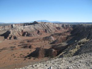
A mesa and desert hike with mountain views, a colorful canyon, sink holes, and seeps.
CautionsSome steep sections, so hiking poles are helpful.
Trailhead Directions
From Albuquerque go north on I-25, then from Bernalillo go northwest on US-550 for 20.9 miles. Turn left on Cabezon Road, about 2 miles before San Ysidro. Almost immediately there is a Y in the road, go left. At 4.5 miles, on the first downhill in the Ojito Wilderness, there will be a parking area on the right. PARK here.
Actual Hike
Go north through the pass on the two track. After a short distance, take a track bearing uphill to the left, which joins a road which passes through some old diggings for gypsum. You will find a spectacular canyon view at CANYON VIEW. Go to the east side of the canyon but do not try to stay near the edge, and find a road which bears north toward a white peak. At the peak one can ascend if desired for a good view of the area at HIGH VIEW. The Nacimiento uplift, the beginning of the Jemez Mountain area, stretches to the north. To the east is “White Mesa”, an extensive gypsum quarry. To continue, go east to EAST RIDGE END and take the trail that goes north along the east edge of the main canyon. At a two track stay left on the trail. Reach a two track and continue north down hill to TRAIL LEFT and turn uphill on the narrow trail to a hole which is a collapsed seep. There will be a seep below and good views. A good place for lunch. Then go down to the seep then turn east, dropping back down onto the road and turn south on that road and shortly reach a split. Stay left toward the east ridge and go onto the bike path which runs south near the east edge of the ridge, affording good views to the west into the canyon. On reaching the EAST RIDGE END turn west and follow the road which turns south and then west near parking.
For a visit to Candle Cave (flashlight or head lamp required), from the SEEP (2.9 mi), go south to SLOT ENTRY (3.0 mi). Continue to the CAIRN (3.1 mi) and take a left (southeast). Walk a short distance to the cave entrance (ENT (3.2 mi)). Pick your way through the narrow opening into a cave. Light a candle or two.
Comments
The BLM calls this area Ojito Bike Trails as White Mesa is actually to the east.
WaypointsPARK: N 35 29.907, W 106 50.486
CANYON VIEW: N 35 30.154, W 106 50.482
HIGH VIEW: N 35 30.427, W 106 50.371
EAST RIDGE END: N 35 30.326, W 106 50.116
TRAIL LEFT: N 35 31.548, W 106 50.752
SEEP: N 35 31.568, W 106 50.798
SLOT ENTRY: N 35 31.451, W 106 50.806
CAIRN: N 35 31.365, W 106 50.799
ENT: N 35 31.326, W 106 50.771
Hike GPS File Name: WhiteMesa-EastRidgeWayTrack_DBDB.gpx
Hike GPS File: Click link to download hike waytrack file
Text Author: Dick Brown
Map Author: Dick Brown
Waypoints Author: Dick Brown
Track Author: Dick Brown
Maintainer: Randy Simons
Editor: Randy Simons